
After sluggish starts to winter in recent years, Mother Nature surprised Wisconsinites with an early dumping of snow this season!
Two separate storms brought huge amounts of snow to the state during the final week of November, creating a headache for Thanksgiving travelers across the Midwest.
Northern Wisconsin Takes a Hit:
On Tuesday, November 25, a strong low-pressure system developed in southern Minnesota and progressed northeastward toward the Upper Peninsula of Michigan. With temperatures in the mid-30s in northwestern Wisconsin, precipitation began as rain in the morning, then transitioned to heavy, wet snow by Tuesday night as temperatures cooled.
Unseasonably warm surface waters of Lake Superior aided in producing potent bands of lake effect snow in Bayfield, Ashland, Iron, and Vilas counties. Lake effect continued in these areas on Wednesday and into Thanksgiving morning.
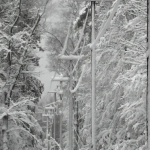
Winds gusting over 40 miles per hour created blizzard-like conditions and snapped tree branches that were weighed down by the heavy snow. Electric company Xcel Energy reported about 14,000 customers without power on Tuesday, many of whom remained without power until Thursday.
Snowfall totals from November 25 through 27 were more than a foot in most of northwestern Wisconsin, with numerous locations reporting higher than 20 inches. The highest reported total was 32.2 inches in Mercer (Iron County).
This storm brought the largest totals and most widespread snowfall to northern Wisconsin by December 1 since 2019.
| Location | Snow totals for November 25-27, 2025 |
|---|---|
| Bayfield Fish Hatchery (Bayfield Co.) | 16.8″ |
| Mason (Bayfield Co.) | 20.2″ |
| Brule (Douglas Co.) | 17.5″ |
| Hurley (Iron Co.) | 29.7″ |
| Pence (Iron Co.) | 25.0″ |
| Hayward (Sawyer Co.) | 10.5″ |
| Presque Isle (Vilas Co.) | 22.0″ |
Southern Wisconsin Gets Buried:
Two days after Thanksgiving, another storm took aim on the Badger State — this time targeting the southern counties. A low-pressure system developed near the Rockies on November 28 and quickly strengthened as it raced toward Lake Michigan.
The position of the system was south of Wisconsin, putting the state in the prime location for both cool air from the north and moisture from the south.
| Location | Snow totals for November 28-30, 2025 |
|---|---|
| Lancaster (Grant Co.) | 13.0″ |
| La Crosse (La Crosse Co.) | 8.2″ |
| Monticello (Green Co.) | 11.5″ |
| Baraboo (Sauk Co.) | 9.0″ |
| Sun Prairie (Dane Co.) | 12.0″ |
| New Berlin (Waukesha Co.) | 12.7″ |
| Sullivan (Jefferson Co.) | 13.0″ |
| Milwaukee (Milwaukee Co.) | 8.0″ |
Snow began on the evening of Friday, November 28, in western Wisconsin, and spread eastward through Saturday morning, quickly covering roadways. Snow fell steadily from sunup to sundown on November 29, finally coming to an end early on Sunday, the 30th.
Madison’s Dane County Regional Airport measured 9.3 inches of snow on November 29, setting a new daily snowfall record for the date (previous record was 6.0 inches set in 1991). It also became the snowiest November day on record in Madison, breaking the old monthly record of 7.6 inches set on November 27, 1995.
The Milwaukee Mitchell Airport reported 6.1 inches on November 29, also a new daily record for the city (previous record was 3.3 inches in 1971).
Over the two days, snow totals in southern Wisconsin ranged from five to 14 inches.
Historical Context:
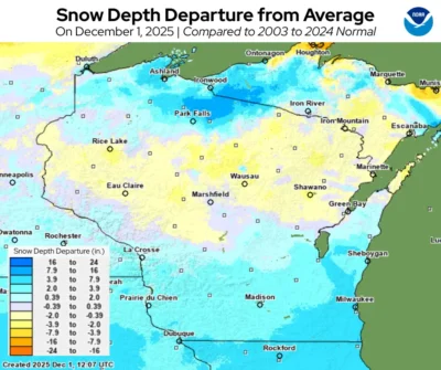
For the first time in over two decades, the entire state of Wisconsin is covered in snow on December 1. In fact, nearly the entire Northern Great Lakes region had snow on the ground to start the new month!
Storms of this size aren’t too unusual in November in northern Wisconsin, but it’s been decades since a November snowstorm of this size hit southern Wisconsin.
La Crosse saw its largest two-day November snow since 1991; Milwaukee its largest since 1995. With a storm total of 11.7 inches, this was the largest November snowstorm on record in Madison.
This is a product of the Wisconsin State Climatology Office. For questions and comments, please contact us by email (stclim@aos.wisc.edu) or phone (608-263-2374).