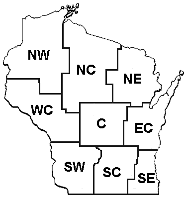
 Wisconsin has nine climate divisions. A climate division has been defined by the National Climatic Data Center to be an area of the state that has relatively uniform climate characteristics.
These regions, which were created in 1950, correspond to the Crop Reporting Districts of the U.S. Department of Agriculture and typically have boundaries corresponding to county and state boundaries, except in mountainous states where topographic features are used to determine the boundaries.
Each Wisconsin climate division comprises several counties.
Here you will find divisional climate normals, temperature, and precipitation data.
View Divisional Climate Data
Divisional Climate Normals
View regional climate averages for temperature, precipitation, and snowfall averaged over the 30-year period from 1991 to 2020.
Divisional 12-Month Temperatures
View regional average temperatures and departures from normal for the last 12 months.
Divisional 12-Month Precipitation
View regional monthly precipitation totals and departures from normal for the last 12 months.
Divisional 12-Month Snowfall
View regional monthly snowfall totals and departures from normal for the last 12 months.
Divisional Long-Term Annual Temperatures
View regional annual average temperatures for each year starting in 1895, and download spreadsheets with monthly, seasonal, and multi-year statistics.
Divisional Long-Term Annual Precipitation
View regional annual average precipitation for each year starting in 1895, and download spreadsheets with monthly, seasonal, and multi-year statistics.
Divisional Modified Growing Degree Day Units
View annual and monthly regional modified growing degree day units, and download spreadsheets with monthly, seasonal, and multi-year statistics.
Divisional Long-Term Annual Heating Degree Days
View regional heating degree days dating back to 1895, and download spreadsheets with monthly, seasonal, and multi-year statistics.
Divisional Long-Term Annual Cooling Degree Days
View regional cooling degree days dating back to 1895, and download spreadsheets with monthly, seasonal, and multi-year statistics.
Divisional Long-Term Annual Palmer Drought Severity Index
View an annual standardized index of regional drought conditions dating back to 1895, and download spreadsheets with monthly statistics.