October was a month of extremes — from record heat to the season’s first flurries. Warm, windy days and underwhelming rainfall shaped everything from drought and leaf-peeping to harvest and the closing of a record-long growing season.
From Heatwave to Hard Freeze
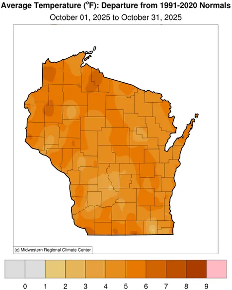
October began with temperatures more fitting for July than fall, averaging nearly 20 degrees warmer than normal across the state (Figure 1).
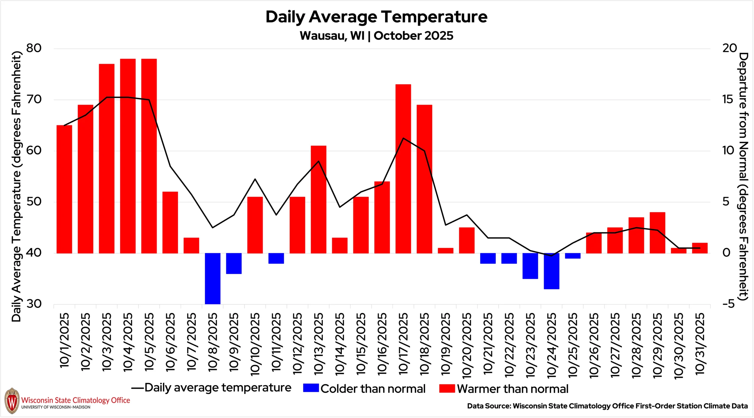
Between October 3 and 6, 65 stations set new daily high temperature records as the mercury climbed. High temperatures reached 90 degrees in La Crosse (La Crosse County) on October 3 and in Lodi (Columbia County), Brodhead (Green County), and Darlington (Lafayette County) on October 4.
The month’s hottest temperature was 91 degrees in Mondovi (Buffalo County) on October 3. Mondovi has only seen the 90s three other times in October since records began in 1908.
Warm nights followed the daytime heat. Over a dozen stations reported record-warm minimum temperatures. The month’s warmest overnight temperature of 69 degrees was observed at five stations, surprisingly located across northwestern Wisconsin: Ashland (Ashland County), Barnes (Bayfield County), Alma Dam (Buffalo County), Brule Ranger Station (Douglas County), and Hayward Ranger Station (Sawyer County).
For comparison, normal low temperatures for early October in the northwoods are in the 30s and 40s, whereas the 60s are closer to where the afternoon highs should be for that time of year.
The pattern shifted dramatically the following week when a cold front swept through on October 5 to 6, bringing widespread frost and freezes by the morning of October 8.
After another warm stretch from October 12 to 20, cooler conditions returned late in the month. The Wisconet station in Grantsburg (Burnett County) recorded the state’s coldest temperature of 18 degrees on October 24.
By month’s end, all six of Wisconsin’s first-order stations recorded frost, capping off record-long frost-free seasons in Green Bay and Wausau. This aligns with a broader trend toward longer frost-free seasons among these locations, defined as the stretch between the last 32 degree freeze of the spring and the first 32 degree freeze of the fall.
Madison, Milwaukee, and Green Bay have seen some of the largest increases in the number of days without frost — gaining roughly 20 to 30 days since 1971 — while Eau Claire, La Crosse, and Wausau have experienced smaller yet notable increases of about five to 15 days.
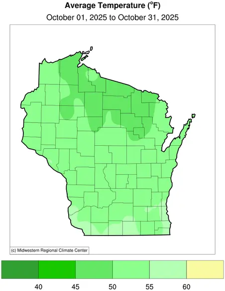
Statewide, October averaged 51.7 degrees, 4.9 degrees above average, Wisconsin’s fourteenth warmest October on record (Figure 2).

Underwhelming Rainfall
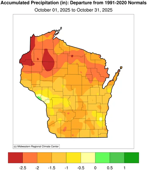
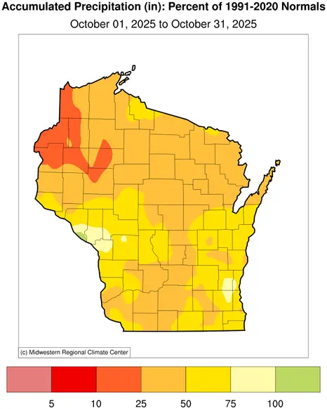
The month was marked by dryness; the entire state fell short of October precipitation averages. The statewide average for the month was 1.27 inches, 1.74 inches drier than average. However, it wasn’t for a lack of rain events!
Wisconsin’s first-order stations reported between nine and 12 days with measurable precipitation during the month (which is near average for October), but the precipitation that fell didn’t add up to much. Wausau saw 12 days with precipitation, yet still had its driest October since 2003 with a monthly total barely over an inch.
Drier still was the northwest region of the state, where many locations saw monthly precipitation totals near or under an inch (Figure 3). Superior (Douglas County) received only 0.42 inches of precipitation, marking the city’s seventh driest October since records began in 1909.
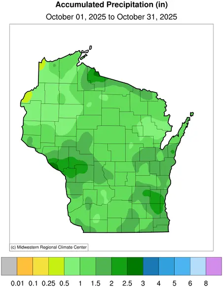

There were, however, a few days mid-month with more substantial precipitation. Showers in western Wisconsin on October 14 to 15 poured nearly an inch of rain from La Crosse to Adams County, with lighter totals elsewhere.
October 18 to 19 saw the only October thunderstorms to move through the state, dropping 1.27 inches of rain in Milwaukee. Local reports of 1.5 to 1.75 inches were seen through eastern Waukesha County.
As cooler temperatures settled in later in the month, some parts of the state got their first taste of winter precipitation!
A type of precipitation called graupel was reported in the Milwaukee area on the morning of October 22. Graupel forms when water droplets collect around snowflakes as they fall through the atmosphere, creating small, soft hail-like pellets that melt quickly once reaching the ground.
With even colder temperatures on the morning of October 23, residents in the Rhinelander area spotted Wisconsin’s first snow flurries of the season!
Drought Intensifies
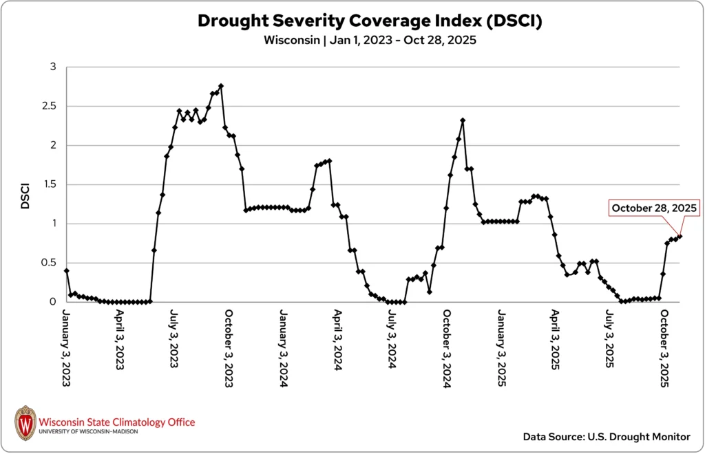
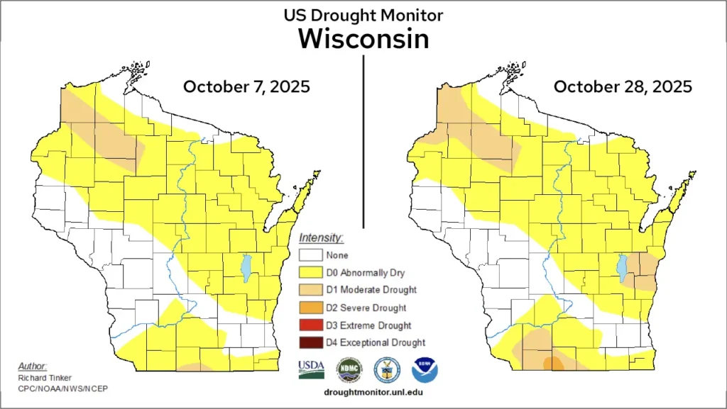
September ended with abnormally dry conditions across northern and southern Wisconsin, and continued dryness in the first week of October allowed moderate drought (D1) to return to the state. This is reflected in the significant jump in the Drought Severity Coverage Index from September 30 to October 7 (Figure 4).
The first pockets of moderate drought emerged in the northwestern and far south-central regions. By mid-month, much of Manitowoc and Sheboygan counties in east-central Wisconsin were in moderate drought as well.
At month’s end, a sliver of severe drought (D2) had emerged in parts of Lafayette and Green Counties in the south (Figure 5). This is the first time in nearly a year that any part of Wisconsin has been in severe drought.
Harvest Continues, Seasons Change
The warm, dry weather that opened October accelerated harvest across Wisconsin. Farmers made rapid progress in fields, though the lack of moisture raised concerns — soybeans may have suffered from shattering, and corn from insufficient moisture content.
The dry and dusty conditions contributed to combine harvester fires, and limited rainfall made establishing cover crops difficult following harvest.
As conditions turned slightly wetter by mid-to-late October, fieldwork slowed somewhat, but the rain slightly improved soil moisture and aided cover crop germination while reducing dust and fire risks. However, muddy fields in some locations created compaction concerns where heavy machinery was used.
Over the past five decades, the growing season (defined as the stretch between the last 32 degree freeze of the spring and the first 32 degree freeze of the fall) has become longer by one to five weeks since 1971 at Wisconsin’s first-order stations. Five of the six stations have seen their last 32 degree spring freeze occur two to 15 days earlier, while all stations have experienced their first 32 degree fall freeze 13 to 20 days later.
For Wisconsin agriculture, extended growing seasons bring both benefits and challenges. They allow earlier planting, later harvesting, and more crop options, but also lengthen the window for pests, weeds, and diseases, increase water demand, and may lead to earlier harvests with reduced yields.
Breezy October Days
Some Wisconsinites may have noticed the gusty feel this month. Fall is naturally windier as low pressure systems sweep across the state and the jet stream makes its usual seasonal migration over Wisconsin, generating stronger winds.
Overall, the mean hourly wind speed at Wisconsin’s six first-order stations was 7.7 miles per hour this month — just 1.3 miles per hour below the October norm.
However, a few periods brought notably stronger breezes. Early in the month, as a cold front moved through between October 5 and 6, the state’s six first-order stations reported daily average wind speeds reaching the lower teens, with peak gusts in the upper 20s to lower 30s.
Another windy stretch occurred October 19 through 22, with a couple of gusts reaching 40 miles per hour in Milwaukee and La Crosse.
While these gusts made their presence felt, the month’s wind was largely typical, serving as a reminder of Wisconsin’s breezy fall seasonal character.
Peak Color Across Wisconsin
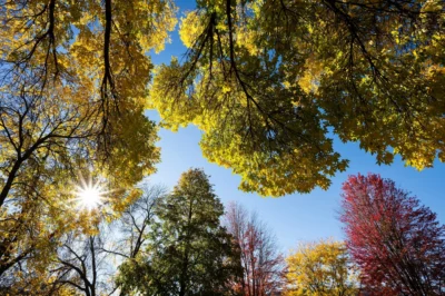
The unusually warm start to fall may have delayed or softened the vibrant leaf colors many anticipate. Even so, Wisconsin put on a show throughout the month.
By mid-October, brilliant hues peaked across the north, according to Wisconsin’s Department of Tourism Fall Color Report.
Though the hard freeze at month’s end brought the leaf-peeping season to a close across much of northern Wisconsin, parts of central and southern areas were still showcasing their peak shades (Image 1).
Climate Corner
The most remembered November storm is the one that sank the Edmund Fitzgerald on Lake Superior in 1975, but over the last century, Wisconsin has experienced several early November storms that often turned deadly. Learn what makes the first weeks of November so storm-prone in this month’s Climate Ed-ucation blog, the Gales of November.
Climate Stats by Division
October 2025 Temperature (degrees Fahrenheit)
Color Key
-
Dark blue: Record coolest
-
Royal blue: Bottom ⅒
-
Light blue: Bottom ⅓
-
White: Normal
-
Light orange: Top ⅓
-
Orange: Top ⅒
-
Red: Record warmest
| Division | Avg | Dept |
|---|---|---|
| Northwest | 50.0Top ⅒ | 5.1Top ⅒ |
| North Central | 49.6:Top ⅓ | 5.3:Top ⅓ |
| Northeast | 49.8:Top ⅓ | 4.6:Top ⅓ |
| West Central | 52.7:Top ⅓ | 5.2:Top ⅓ |
| Central | 52.4:Top ⅓ | 4.8:Top ⅓ |
| East Central | 53.5:Top ⅒ | 5.2:Top ⅒ |
| Southwest | 53.6:Top ⅓ | 4.4:Top ⅓ |
| South Central | 54.3:Top ⅒ | 4.6:Top ⅒ |
| Southeast | 54.7:Top ⅒ | 4.5:Top ⅒ |
| State | 51.7:Top ⅓ | 4.9:Top ⅓ |
Heating Degree Days
Color Key
-
Dark blue: Record most
-
Royal blue: Top ⅒
-
Light blue: Top ⅓
-
White: Normal
-
Light orange: Bottom ⅓
-
Orange: Bottom ⅒
-
Red: Record fewest
| October 2025 | Since July 1, 2025 | |||
|---|---|---|---|---|
| Division | Avg | Dept | Avg | Dept |
| Northwest | 465: Bottom ⅒ | -159: Bottom ⅒ | 710: Bottom ⅒ | -253: Bottom ⅒ |
| North Central | 477: Bottom ⅒ | -164: Bottom ⅒ | 775: Bottom ⅒ | -251: Bottom ⅒ |
| Northeast | 471: Bottom ⅒ | -143: Bottom ⅒ | 750: Bottom ⅒ | -217: Bottom ⅒ |
| West Central | 390: Bottom ⅓ | -153: Bottom ⅓ | 538: Bottom ⅒ | -235: Bottom ⅒ |
| Central | 398: Bottom ⅓ | -144: Bottom ⅓ | 561: Bottom ⅒ | -223: Bottom ⅒ |
| East Central | 364: Bottom ⅒ | -154: Bottom ⅒ | 524: Bottom ⅒ | -219: Bottom ⅒ |
| Southwest | 363: Bottom ⅓ | -128: Bottom ⅓ | 490: Bottom ⅒ | -195: Bottom ⅒ |
| South Central | 343: Bottom ⅒ | -134: Bottom ⅒ | 456:Bottom ⅒ | -198: Bottom ⅒ |
| Southeast | 330:Bottom ⅒ | -133: Bottom ⅒ | 456: Bottom ⅒ | -176: Bottom ⅒ |
| State | 367: Bottom ⅒ | -142: Bottom ⅒ | 520: Bottom ⅒ | -204: Bottom ⅒ |
Snowfall (inches)
Color Key
-
Purple: Below Normal
-
White: Normal
-
Beige: Above Normal
| Division | Avg | Dept |
|---|---|---|
| Northwest | 0Below Normal | -0.9Below Normal |
| North Central | 0:Below Normal | -1.5:Below Normal |
| Northeast | 0:Below Normal | -0.9:Below Normal |
| West Central | 0:Below Normal | -0.4:Below Normal |
| Central | 0:Below Normal | -0.4:Below Normal |
| East Central | 0:Below Normal | -0.3:Below Normal |
| Southwest | 0:Below Normal | -0.3:Below Normal |
| South Central | 0:Below Normal | -0.3:Below Normal |
| Southeast | 0:Below Normal | -0.2:Below Normal |
| State | 0:Below Normal | -0.7:Below Normal |
Liquid-Equivalent Precipitation (Inches)
Color Key
-
Dark brown: Record driest
-
Light brown: Bottom ⅒
-
Beige: Bottom ⅓
-
White: Normal
-
Light green: Top ⅓
-
Green: Top ⅒
-
Dark green: Record wettest
| October 2025 | Since Nov. 1, 2024 | |||
|---|---|---|---|---|
| Division | Avg | Dept | Avg | Dept |
| Northwest | 0.83: Bottom ⅒ | -2.34: Bottom ⅒ | 28.74: Normal | -3.80: Normal |
| North Central | 1.42: Bottom ⅓ | -1.85: Bottom ⅓ | 32.75: Normal | -0.62: Normal |
| Northeast | 1.00: Bottom ⅒ | -2.14: Bottom ⅒ | 32.30: Normal | 0.25: Normal |
| West Central | 1.46: Bottom ⅓ | -1.31: Bottom ⅓ | 34.63: Top ⅓ | -0.23: Top ⅓ |
| Central | 1.37: Bottom ⅓ | -1.41: Bottom ⅓ | 34.01: Top ⅓ | 0.05: Top ⅓ |
| East Central | 1.53: Bottom ⅓ | -1.42: Bottom ⅓ | 30.65: Normal | -2.03: Normal |
| Southwest | 1.28: Bottom ⅓ | -1.56: Bottom ⅓ | 35.85: Top ⅓ | -1.78: Top ⅓ |
| South Central | 1.36:Bottom ⅓ | -1.52:Bottom ⅓ | 32.81: Normal | -3.88: Normal |
| Southeast | 1.67: Bottom ⅓ | -1.24:Bottom ⅓ | 34.46 Normal | -0.87 Normal |
| State | 1.27:Bottom ⅓ | -1.74Bottom ⅓ | 32.57 Normal | -1.48 Normal |
Monthly, seasonal, and annual temperature and precipitation values and rankings published in this report are from NOAA’s National Centers for Environmental Information at the time of posting this climate summary. Values and rankings can change after publishing our climate summaries. To check the most recent values and rankings, visit NOAA’s National Centers for Environmental Information Climate at a Glance Tool.
This report is a product of the Wisconsin State Climatology Office. For questions and comments, please contact us by email (stclim@aos.wisc.edu) or phone (608-263-2374).