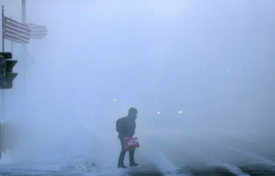
Any true Midwesterner knows that when it comes to winter weather, wind makes all the difference.
“It wouldn’t be so bad without the wind!” has become a common affirmation to reassure residents of their decision to live in a place where wind chills of 20 below zero are a common occurrence.
What is Wind Chill?
Wind chill represents an apparent or “feels like” temperature that humans or animals experience when they are outside and exposed to frigid air and winds.
The National Weather Service (NWS) uses an equation to measure wind chill that calculates the rate of heat loss from exposed skin due to wind and cold. Stronger wind speeds draw heat from the body at a faster rate, lowering skin temperature and the internal body temperature.
Wind chills are calculated using sustained winds, not wind gusts. The NWS provides a wind chill calculator to determine the amount of time for frostbite to occur on exposed skin in varying conditions.
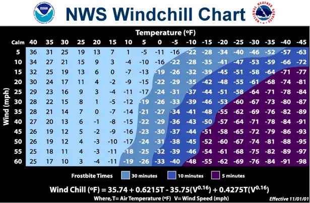
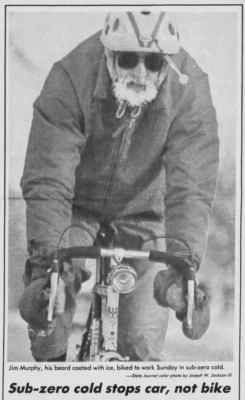
Individuals who are outside and not properly prepared for frigid wind chills may experience frostbite or hypothermia within 30 minutes.
Cold wind chills are not just an uncomfortable nuisance; they can be harmful and even deadly. According to the Wisconsin Department of Health Services (DHS), an average of 60 cold-related deaths have occurred in Wisconsin each year from 2015 to 2024. Since 2018, an average of 350 people in the state have been hospitalized due to cold-weather-related illnesses or injuries each year.
Many of these deaths and injuries could be attributed to those who suffered hypothermia while unprepared for the added cold from the wind. DHS Climate and Health Program Manager Kate Beardmore says that since Wisconsin is a cold-weather state, people tend to let their guard down during the winter months. She encourages residents to dress for the cold and to have emergency kits prepared just in case.
Evolution of the Wind Chill Factor
The concept of a wind chill index was initially devised by an Eagle Scout in Antarctica in 1939. The NWS began to regularly use the “wind chill equivalent temperature” in forecasts in 1973, though a wind chill index wasn’t officially implemented until the 2001-02 winter season.
Advances in heat transfer theory, human physiology, technology, and computer modeling have allowed the NWS to create a new and more accurate equation for calculating wind chill temperature.
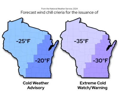
To simplify the communication of dangerous cold weather, the NWS changed the names for wind chill alerts in 2024 to better inform the public of dangerously cold conditions. The name change de-emphasizes the wind aspect of the threat for simpler messaging.
For example, a cold weather advisory is issued if wind chills are expected to drop to between minus 20 to 29 degrees Fahrenheit in southern and eastern Wisconsin. An extreme cold warning would be posted for anticipated wind chills reaching minus 30 degrees in the southern and eastern areas, or minus 35 degrees for the northern and western regions.
Wisconsin’s Wind Chill Climatology
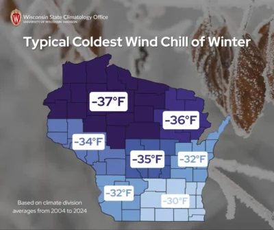
The Wisconsin State Climatology Office calculated the frequency of dangerous wind chill conditions during the winter months (December through February) using data from 1991 through 2020.
The western and central regions of northern Wisconsin experience extreme wind chills more frequently than areas south and east. On average, Wausau (Marathon County) spends 100.7 hours per winter with a feels-like temperature of minus 20 or colder — that’s equivalent to more than four days!
| Average Number of Hours with Wind Chill of X°F Each Winter | |||
|---|---|---|---|
| Location | -20°F or colder | -30°F or colder | -40°F or colder |
| Milwaukee | 32.5 | 7.5 | 1.6 |
| Madison | 35.1 | 7.3 | 2.0 |
| La Crosse | 65.7 | 12.5 | 3.3 |
| Green Bay | 68.2 | 16.5 | 3.6 |
| Eau Claire | 94.5 | 22.6 | 4.8 |
| Wausau | 100.7 | 24.5 | 5.3 |
| Duluth, MN | 255.3 | 101.3 | 26.6 |
Over the last 29 years, the lowest wind chills for each station in Wisconsin have occurred during January. Locations across northern and western Wisconsin have had the coldest readings. In a typical winter, Northwest Wisconsin sees wind chills drop colder than 35 below, at which frostbite can develop on exposed skin in just 15 minutes.
Some of the difference is due to colder air temperatures across the north and away from the moderating influence of Lake Michigan. Another impact is the prevailing winds across western Wisconsin and adjoining sections of Minnesota and Iowa, due to flatter terrain and lower vegetation cover, in contrast to the more forested areas to the east and north.
How Low Can We Go?
You may wonder what the lowest wind chill in Wisconsin history is. Unfortunately, the National Centers for Environmental Information does not track wind chill as part of their state records database, so there’s no official state record.
For years, wind chills were calculated from wind speeds obtained by instruments that were often positioned at various heights above the ground.
Although some colder wind chills have been reported, our office found that the lowest documented wind chill in Wisconsin was in Dunn County in 2019.
An arctic air mass spread across the Upper Mississippi Valley from January 29 to 30, 2019, and resulted in record low wind chills at ten ASOS weather stations across Wisconsin.
The Menomonie Municipal Airport (Dunn County) measured a wind chill of 60 degrees below zero on the morning of January 30, 2019! At the time, the air temperature was 33 degrees below zero with a sustained westerly wind of 13 miles per hour.
The Menomonie record edges out the previous state record of minus 59 degrees, reached nearby at the Eau Claire airport (now the Chippewa Valley Regional Airport) on January 10, 1982, when the air temperature dropped to minus 28 degrees with winds of 21 miles per hour.
On that same date, La Crosse and Milwaukee reported record wind chills of 57 and 56 below zero.
This day is noted for the arctic air mass that centered over the Upper Midwest and was responsible for the wind chill of minus 38 degrees during the “Freezer Bowl” in Cincinnati, Ohio. This was the second coldest game in National Football League (NFL) history.
For curious readers, the coldest football game in NFL history by air temperature was the 1967 Ice Bowl at Lambeau Field, with a temperature of minus 13 degrees, and a wind chill of minus 36.
The Chilling Future
Wisconsin winters have been becoming warmer over the last 50 years, with fewer extreme cold spells, according to the 2021 WICCI Assessment Report.
However, this doesn’t mean that Wisconsin’s winters will always be balmy. As global temperatures warm, the polar vortex over the Arctic could become more unstable. In these situations, frigid air could escape the Arctic Circle and blast the Midwest with dangerous wind chills.
This is a product of the Wisconsin State Climatology Office. For questions and comments, please contact us by email (stclim@aos.wisc.edu) or phone (608-263-2374).