December was a record warm month in Wisconsin that generally felt like a continuation of November. The exceptional temperatures greatly delayed ice formation on inland lakes and the Great Lakes, and they also suppressed snowfall and snow cover.
Record Heat
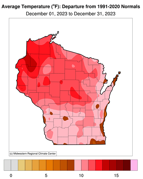
Last month was Wisconsin’s warmest December since official statewide record-keeping began in 1895. The statewide temperature anomaly (departure from average) was a whopping 10.9 degrees Fahrenheit above the 1991-2020 normal.
On top of being a record-breaker, last month was the first time that a statewide average December temperature in Wisconsin (32.3 degrees Fahrenheit) was above the freezing point. In fact, December was so warm that it finished only 2.3 degrees Fahrenheit colder than November, which explains why our December felt a lot like an extension of the prior month. Not only that, but December’s departure from the long-term average landed among Wisconsin’s top 10 largest for any month.
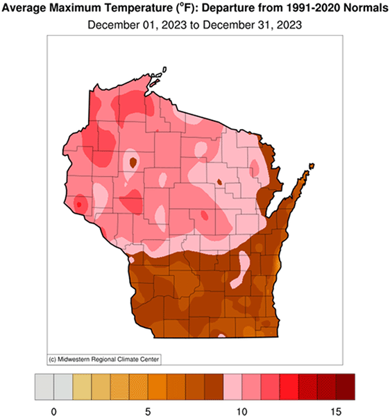
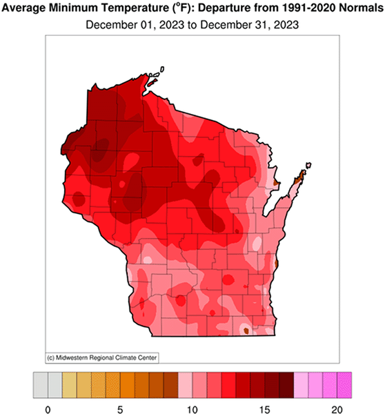
The northern half of the state was especially warm compared to normal, registering widespread daily-average temperature anomalies of more than 11 degrees Fahrenheit. Nighttime low temperatures were even more remarkable: as much as 13-15 degrees Fahrenheit above average across the north and northwest (12.1 degrees Fahrenheit statewide average). A scarcity of snow cover helped to amplify the December warmth, particularly the absence of a deep snowpack that helps depress temperatures at night.
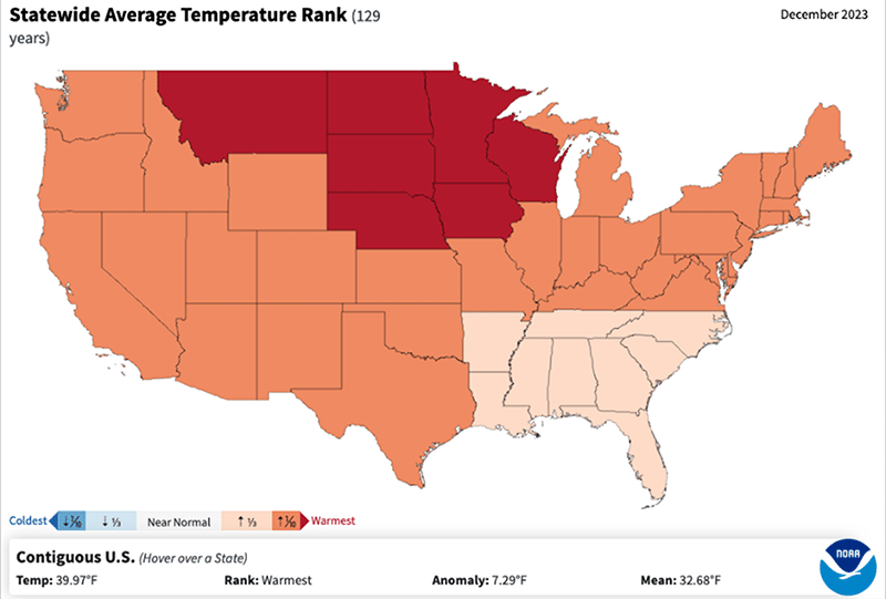
Wisconsin was not alone in its exceptionally mild end to 2023. Most states over the Upper Midwest and Northern Plains also had their warmest December on record, as indicated by the red shading on the map below. Most other states ranged among their 10 warmest Decembers (orange shading), leading to last month becoming the nation’s warmest December on record.
Unusual winter warmth centered over the northern U.S. is a typical fingerprint of a strong El Niño event, which emerged and matured over the tropical Pacific Ocean last year. Wisconsin tends to experience mild winters during powerful El Niños, but that relationship has become entangled with the overall tendency for mild winters during the past 25 years.
Minimal Snow and Ice
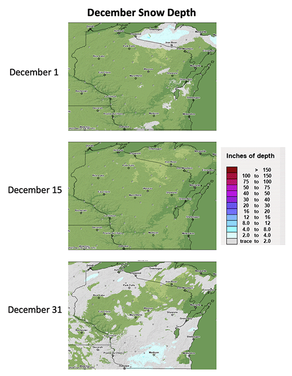
Not surprisingly, the extraordinary December warmth meant that our usual early-winter snowpack and ice cover was scarce or outright absent. Even in northern Wisconsin and the lake-effect snowbelt downstream of Lake Superior, snow cover was a rarity all month. This oddity is illustrated by the maps below, which show the state’s snow depth at the beginning, middle, and end of December. Unfortunately, the lack of a snowpack put a damper on winter recreation and hurt the state’s winter tourism industry.
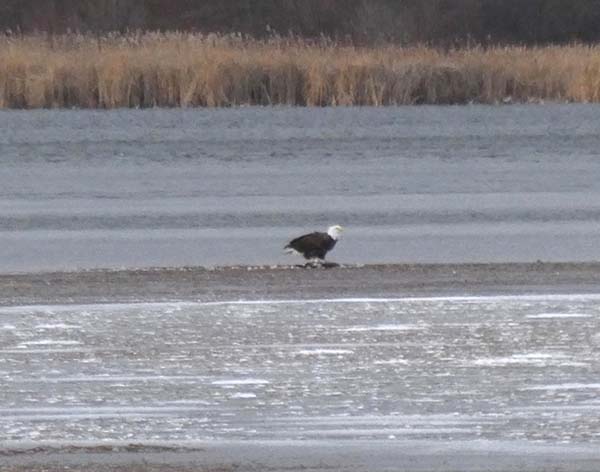
It wasn’t just snow cover that was absent; our state’s lakes were also very slow to ice over during December, if the ice formed at all. For example, Madison’s Lake Wingra, which often freezes during November, froze and thawed a couple times before finally icing over for good on January 5 for only the second January freeze-up on record. The confused-looking eagle below that was perched on a patchy Lake Wingra ice floe during mid-December illustrates the odd conditions last month.
Precipitation Mostly Uneventful
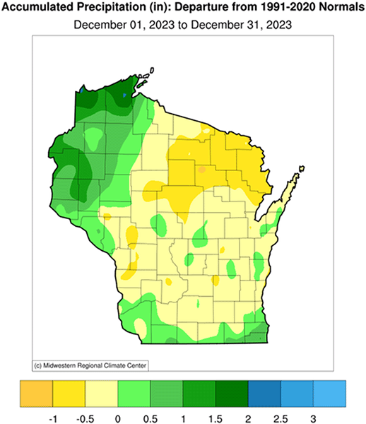
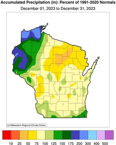
Compared with the headline-grabbing warmth last month, Wisconsin’s precipitation during December was barely newsworthy. The final month of the year registered 1.5 inches of precipitation statewide, a scant 0.02 inches less than the 1991-2020 normal. But one notable region was far northwestern Wisconsin, where some locations were more than 1 inch wetter than normal during December (50 percent or higher anomaly), and secondarily a dry region in northern Wisconsin (more than 50 percent below normal).
Strangely, the relatively heavy precipitation in the extreme northwest was mostly liquid, and most of it fell during a late-month storm that dumped an unseasonably heavy 1 to 2 inches of rain.
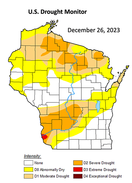
Although drought is far from most of our minds in the midst of winter, Wisconsin remains in substantial drought as a carryover from last summer. In fact, parts of Crawford and Grant Counties remained in extreme drought through December, while much of the rest of Wisconsin continued in severe or moderate drought. These dry conditions are illustrated by the U.S. Drought Monitor’s final assessment of December, which looked almost identical to the first map of the month.
Snowfall … or Lack Thereof
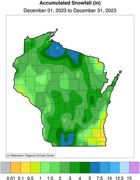
Although Wisconsin’s overall precipitation in December was very close to average, not a lot of it fell in flaky form. As depicted in the map below, snowfall almost everywhere was less than 7 inches, and the vast majority of the state picked up less than 4 inches. The most snow-deprived region was far southeastern Wisconsin, where Milwaukee reported only a trace of snow during all of December for the first time since 1943. Not surprisingly, a White Christmas was not in the cards across the entire state, as springlike conditions took hold instead.
