November was a very dry month in Wisconsin, yet the state’s drought status remained nearly unchanged, with more than one-third of Wisconsin remaining in at least moderate drought and one-sixth of the state continuing in severe or extreme drought. The month was also on the warm side, continuing the very warm 2023 both in our state and globally.
Arid November
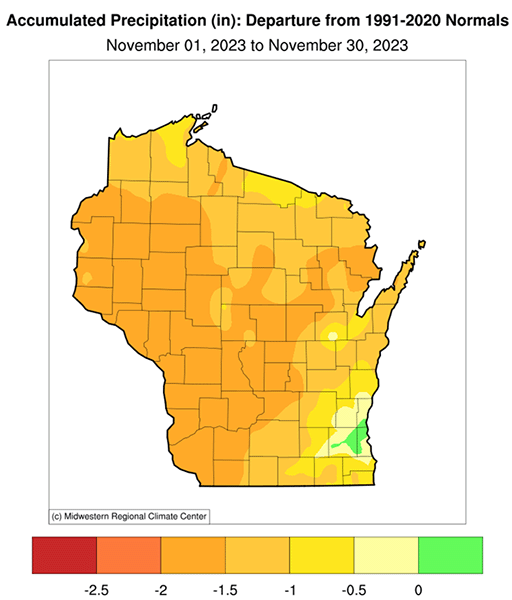
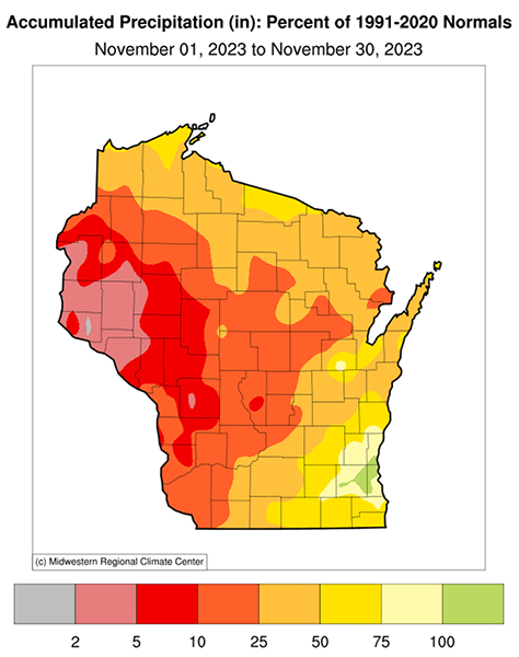
Because dryness outside of the growing season is less noticeable, last month’s aridity happened quietly but was very pronounced. A meager 0.53 inches of precipitation fell statewide, resulting in the eighth-driest November on record in Wisconsin since records began in 1895. The state received only 27 percent of its usual November precipitation, making the month the driest of the year in relative terms, despite the prevalence of severe drought conditions during 2023.
Even May and June, the months that ushered in the drought, produced about 40 percent of normal rainfall (based on the 1991-2020 average). In fact, relative to normal, November was the driest month in Wisconsin since November 2007. Only a very small portion of southeast Wisconsin around Milwaukee received (slightly) more precipitation than normal last month, whereas a lot of the state picked up less than 25 percent of normal, and much of western Wisconsin recorded less than 10 percent of the usual amount.
Drought Status Quo
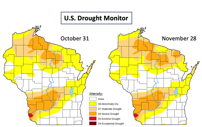
Surprisingly, the very dry November hardly affected our state’s drought status. The U.S. Drought Monitor maps at the beginning and end of the month look nearly the same. The reason why the precipitation shortfall in November had so little impact on drought is because soils at that time of year are so cold and evapotranspiration from plants is so minimal that not much soil moisture is lost. However, it’s important to note that more than one-third of Wisconsin remained in at least moderate drought during November and one-sixth of the state continued in severe or extreme drought. Although the harvest has ended, dry soils still are a concern for farmers planting cover crops, which need moisture for germination to establish themselves before winter sets in.
November Snowfall
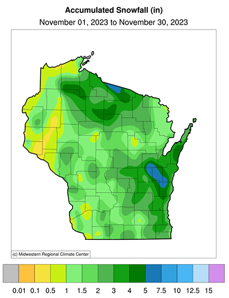
Despite the scarcity of precipitation last month, there were still some snowflakes in the air. November is usually the first month with measurable snowfall across the entire state, and this year was no exception. Most of Wisconsin reported at least 1 inch of snow, and a few locations had more than 4 inches. About half a foot fell during the month in a small pocket of east-central Wisconsin centered on Calumet County, but most of the snow that fell during November quickly melted, due to the warm ground and above-normal air temperatures.
Autumn Precipitation: a Lot, a Little, and About Right
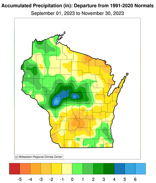
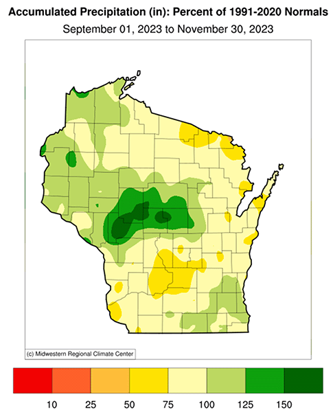
Despite our exceptionally dry November, precipitation during meteorological autumn (September-November) was close to typical. Thanks to an unusually wet October and near-normal rainfall in September, Wisconsin finished the season just 0.34 inches (4 percent) below the 1991-2020 average. Only a swath of north-central and west-central Wisconsin were unusually wet during autumn, with a few locations more than 4 inches above normal and a broader region with 25 percent or more precipitation than normal.
Precipitation Ping Pong in 2023
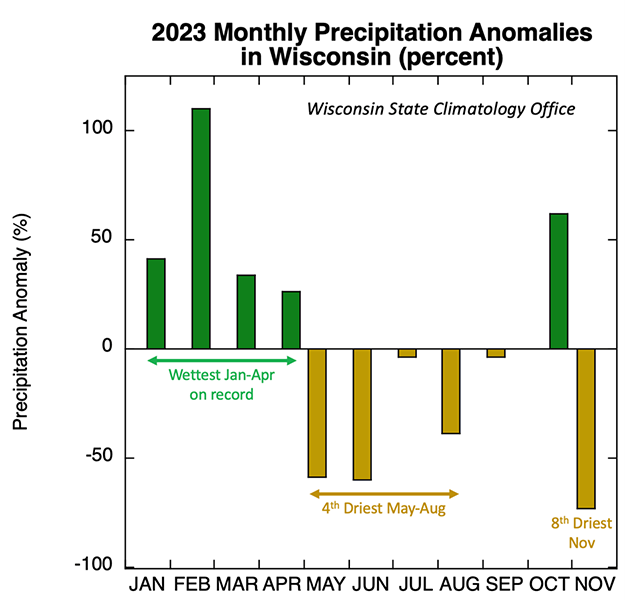
As exemplified by the recently ended autumn season, this year has been memorable for its month-to-month precipitation extremes in both directions: record wet and nearly record dry. After January to April set a record for the wettest start to a year in Wisconsin, the subsequent months were the fourth-driest May to August, followed by an exceptionally wet October and then the eighth-driest November.
The graph below illustrates these back-and-forth precipitation anomalies statewide this year, relative to the entire long-term average spanning 1895 to 2023. Interestingly, the year-to-date total precipitation through November registered just 6 percent shy of the long-term average, despite all the “precipitation ping pong” within the year.
Although the extreme monthly and seasonal variations have been challenging for growers, other parts of the hydrologic system, such as spring flows and groundwater levels, are mostly influenced by accumulated precipitation over seasons and longer, so they haven’t been very affected by the remarkable short-term variability this year.
Another Warm Month
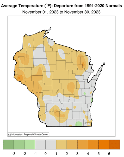
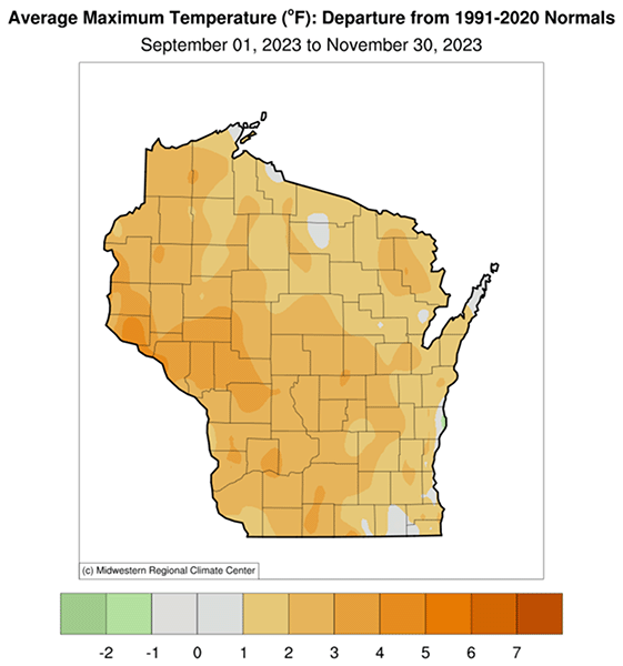
November continued the warm pattern that has prevailed throughout most of this year, checking in at 1.3 degrees Fahrenheit above the 1991-2020 normal. Although that places the month rather unremarkably as the 34th-warmest November on record, it maintained the mildness of 2023. Only March and July of this year were warmer than normal, but not by a lot. Northern, central, and western Wisconsin experienced the largest positive temperature anomalies last month, generally more than 1 degree Fahrenheit, but nowhere was the November warmth exceptional.
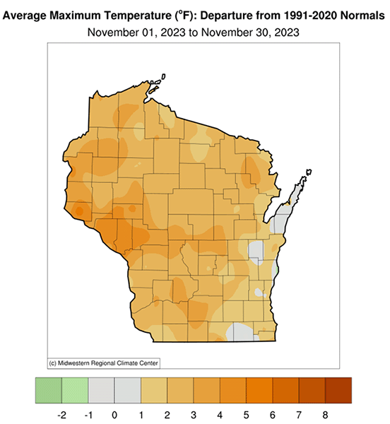
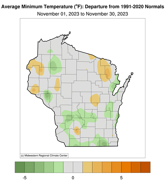
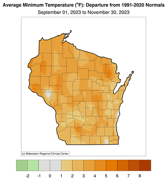
As is typical with dry masses that were the rule last month, daily high temperatures exceeded normals more than daily lows did (see climate summaries for May and June). Positive daily high temperature anomalies greater than 1 degree Fahrenheit prevailed over the vast majority of the state (the statewide average is 2.6 degrees Fahrenheit), whereas daily low temperatures tracked right at or near normal across most of Wisconsin (0.1 degree Fahrenheit cooler than normal state average).
Another Warm Season
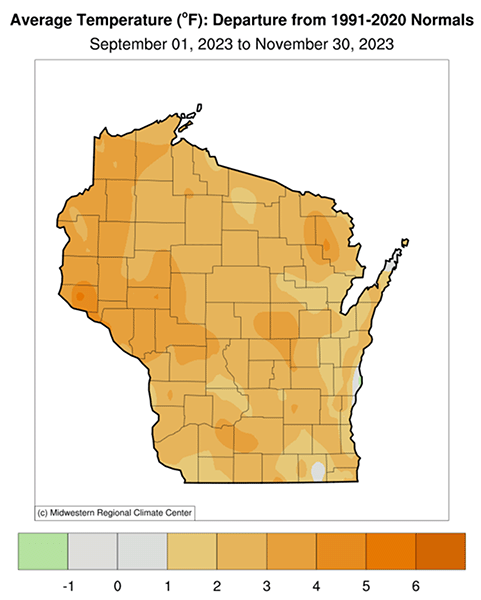
Even though November’s warmth was modest, meteorological autumn on the whole was very mild. The statewide average September-November temperature was 2.5 degree Fahrenheit above normal, which made it the eighth-warmest autumn on record. This warmth continues a recent trend: four of the ten warmest autumns have occurred during just the past decade. Nearly all of Wisconsin was warmer than normal this fall, and there was remarkable symmetry in the positive temperature anomalies between daytime highs (2.3 degrees Fahrenheit above the state average) and nighttime lows (2.8 degrees Fahrenheit above the state average).
Winter Outlook
There is a lot of interest in how the ongoing moderate-to-strong El Niño event, as designated by NOAA’s Climate Prediction Center, will affect Wisconsin’s weather this winter. An El Niño is a semi-cyclical warming of the near-equatorial Pacific Ocean that can produce “teleconnections” of weather impacts across the world. The impacts are usually most pronounced during Northern Hemisphere winter, when El Niños are in their mature phase.
In the United States, El Niños commonly favor wet conditions from southern California to the Atlantic coast and warm winters in the Upper Midwest, especially the strongest events. As such, the winter outlook for December 2023 to February 2024 from the Climate Prediction Center is calling for an increased likelihood of above-normal temperatures in Wisconsin this winter, along with a weaker indication of drier-than-normal conditions.
But it’s important to notice that the elevated chance of a mild winter is actually quite modest. Compared with purely random odds of a winter having a one-in-three (33.3 percent) chance of being warm, cold or near normal, the Climate Prediction Center’s outlook shows Wisconsin’s probability of a relatively warm winter between 40 percent to 50 percent.
This forecast implies that the upcoming winter is actually somewhat more likely to be either near-normal or colder than average. The reason is that El Niño is not “the only show in town” when it comes to affecting our weather. The climate system is extremely complicated and involves numerous factors influencing our weather simultaneously. As an example, the four strong and eight moderate El Niños since 1950 produced the following winter temperature anomaly patterns.
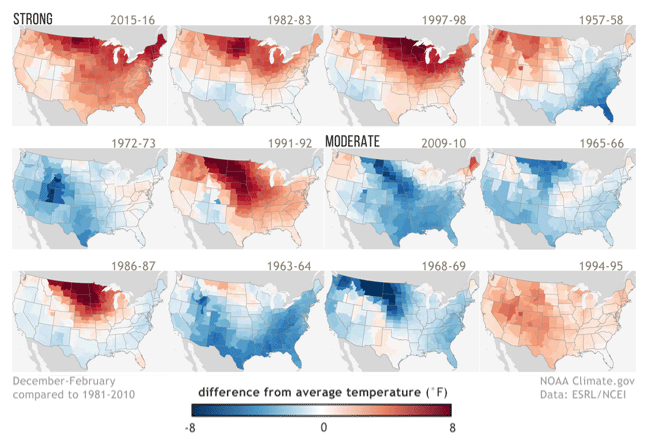
These maps show that although Wisconsin did experience a warm winter during three of the strongest El Niños (top row), the other event did not follow suit (1957-58). Contrarian winters are even more common for El Niños of only moderate strength (bottom two rows).
If history is any guide for the upcoming winter, we should be cautious in our expectations of a mild season ahead. At the time of this writing, however, December looks as if it will be an unusually warm month in Wisconsin, which boosts the likelihood of the winter average temperature being above normal as well. For more information on the effects of El Niño on weather patterns, see the series of recent NOAA blogs on various aspects of this phenomenon.
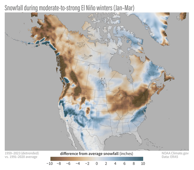
Snow Drought?
The combination of El Niños favoring mild and somewhat dry Wisconsin winters means that these events typically coincide with less snowfall than normal. This is the case not only in our state but over most of the Midwest, as shown below in the figure from one of the recent NOAA blogs. If indeed our winter ahead is snow-challenged, it would be a huge contrast with the most recent snow season of 2022–23, when Wisconsin received a record amount. Therefore, a safe prediction would be that we will not get as much accumulation as last snow season, regardless of El Niño!