As hunters across Wisconsin gear up for the gun deer season this November, many are watching the forecast — hoping for just the right conditions to keep deer moving and hands warm.

How does weather shape deer season success?
Weather is not the only factor in harvest success, but it certainly sets the tone for the hunt. Temperature has varying influences, as hunters and deer respond differently to extremes. When it feels like Antarctica, hunters may not stay out as long; when there’s a heat wave, deer might not be as active.
Barometric pressure and wind are a few other variables that some hunters pay close attention to. When pressure is high or it rapidly changes before a weather system, hunters may notice increased deer movement. Stronger winds often accompany these systems, and some hunters report better luck once those winds calm down.
Snow cover, on the other hand, tends to have a clearer connection to harvest success. Generally, when there is snow on the ground — especially during opening weekend — harvest numbers are higher. Deer are easier to spot against a white background, and hunters can more easily follow tracks. The last time Wisconsin had widespread snow cover during opening weekend was in 2022, which also saw a comparatively higher harvest.
It is also worth noting that the conditions leading up to the season can be just as important as the weather during it. In general, colder temperatures during the rut — which typically peaks before Wisconsin’s gun season — increases deer movement.
Conditions in the previous winter, spring, or summer also influence success. For example, December 2013 through April 2014 brought persistent cold and deep snow. It was the second-coldest December through April on record in Wisconsin, and snowfall was as much as 20 inches above normal across the southern half of the state and up to 80 inches above normal for northern Wisconsin.
Those severe conditions led to higher deer mortality and reduced fawn production. That, in turn, reduced deer numbers and contributed to the lower harvest in 2014.
What’s a typical season like?
Wisconsin’s gun deer season can open as early as November 17 or as late as November 23. To capture that full range, we analyzed the entire possible gun-season window — November 17 through December 1 over the last 30 years or so.
Across this window, temperatures tend to run from lows in the upper teens to low 30s and highs in the low 30s to mid-40s, with the northwest leaning cooler and the southeast warmer. As the season gets later, a more consistent chill settles in.


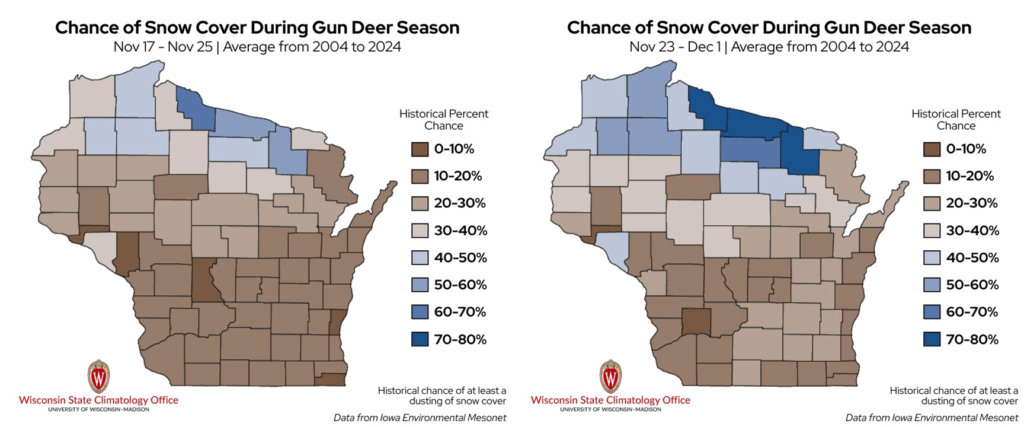
Most of Wisconsin sees very light snowfall — typically less than half an inch. Early in the season, only a couple dozen counties pick up between 0.5 and 1.5 inches of snow, mostly clustered in northwestern, west-central, and southern Wisconsin. As the season moves toward December, a few more counties join that group.
Chances for a dusting of snow cover also improve slightly closer to December — by roughly 10% — but much of the state still sees less than a 40% chance of snow on the ground during either period. The northernmost part of the state is usually the only area able to hold onto a light snowpack of 0.5 to 1.5 inches throughout the season.
Precipitation (rain plus melted snow) tends to be minimal throughout the 14-day window. On average, most of the state picks up only about 0.1 to 0.3 inches, with the slightly higher amounts stretching from southwestern to northeastern Wisconsin.

Winds average around 9 miles per hour during the full gun-season window, and skies are typically about 60% cloud-covered.
What are some of the most extreme conditions we’ve faced in the stand?
Of course, no two hunting seasons are the same. Some feel more like late fall, others more like midwinter. Looking across the full stretch of season dates (November 17 — December 1), you start to see just how extreme things can get:
- The warmest season was in 2001, with a statewide average temperature of 39°F and an average high temperature of 47°F.
- The coldest season was in 2014, with a statewide average temperature of 19°F and an average low temperature of 11°F.
- The snowiest season was in 2019, with a statewide average total snowfall of 0.49 inches per day and the Bayfield Fish Hatchery (Bayfield County) recording a whopping 25 inches of snowfall on December 1.
- The season with the deepest snowpack was in 2014, with a statewide average total snowpack of 3.36 inches of snow at each station.
- The wettest season was in 1991, with a statewide average total precipitation of 3.15 inches.
- The windiest season was in 1994, with a statewide average wind speed of 14.2 miles per hour.
What was the weather during the most and least successful seasons?
Wisconsin saw one of the highest harvests on record in 2006, and one of the lowest in 2019. You might be quick to assume that weather was a major factor — and you may be onto something.
In 2006, conditions were relatively easy going across the state: an average temperature of 35°F, just over an inch of precipitation, light winds under 10 miles per hour, and just 0.08 inches of snowpack.
In 2019, temperature and wind speed were similar to 2006, but hunters faced a very different backdrop — the third-wettest season since 1979 and 1.14 inches of snow cover.
However, the weather was not the only thing influencing harvest success those years. The 2006 season was near the peak of the Earn-A-Buck era, when hunters in much of the state were required to harvest an antlerless deer before harvesting a buck.
In contrast, 2019 was a late-opener year and also had the slowest corn harvest progress on record. Standing corn can make it harder for hunters to see deer, and it also means less accessible grain on the ground for deer to feed on. As a result, the abundance of unharvested fields that season may have contributed to the lower harvest.
While weather during the season can make or break the experience, broader seasonal patterns — and factors beyond weather — together influence the overall success of Wisconsin’s gun deer season.
How has the season’s weather changed over the years?
Since 1951, temperatures during Wisconsin’s gun deer season have warmed, but the change is more noticeable later in the season. Early-season highs have crept up slowly, rising roughly 1°F to 6°F across the state over the past 70 years. Late-season highs, on the other hand, have increased more noticeably, with temperatures now about 4°F to 9°F warmer than in the 1950s.
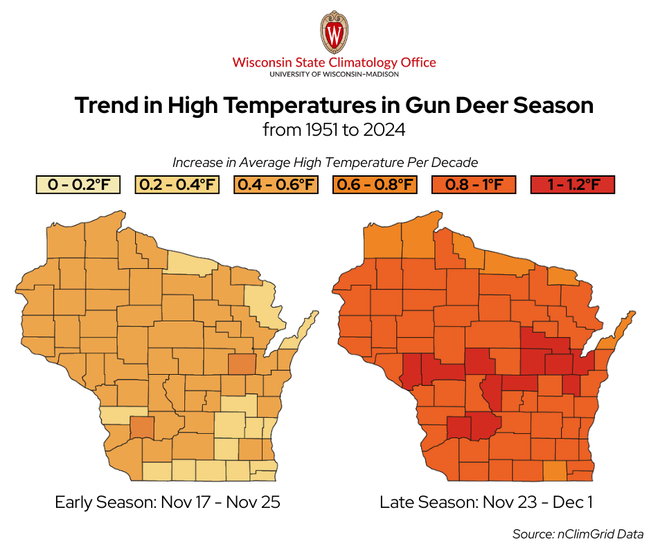
The story is similar for lows. Early-season lows have edged up by a couple of degrees, while late-season lows have seen a bigger jump over time, by roughly 4°F to 9°F since 1951.
Overall, central Wisconsin has warmed faster than much of the rest of the state.
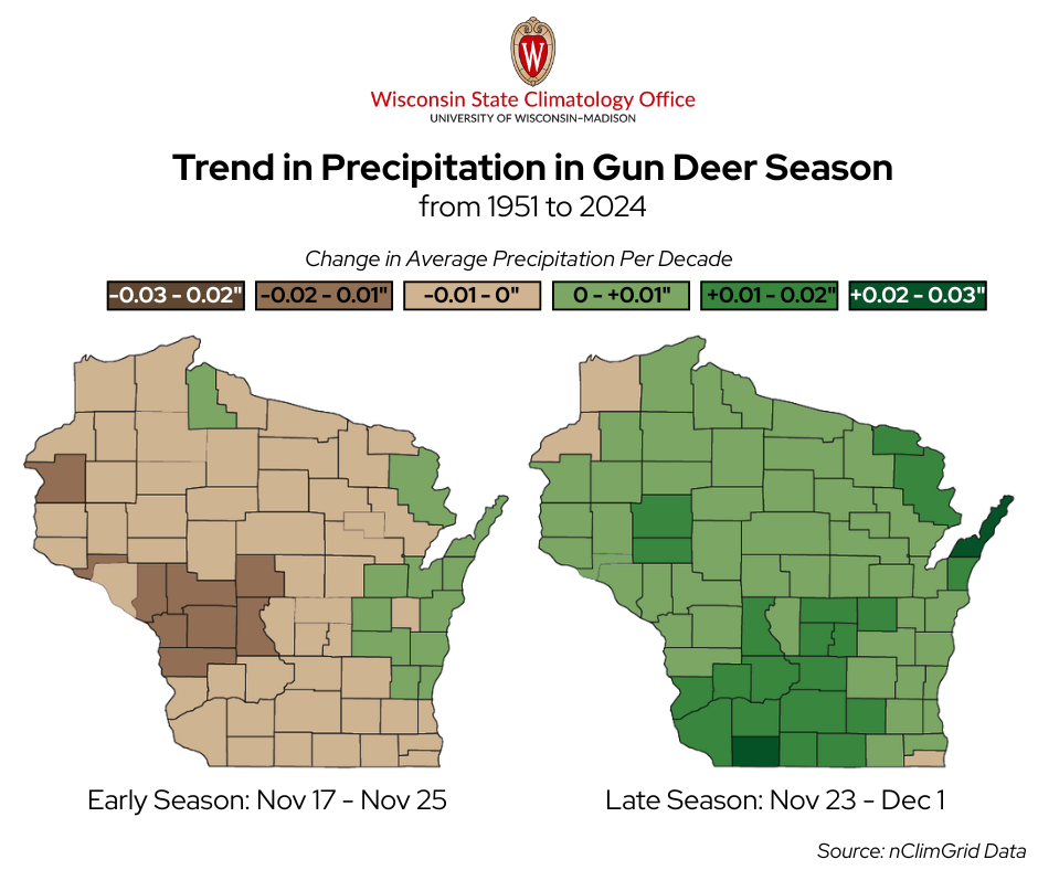
Precipitation changes are small, but a pattern does emerge. Early-season conditions have become a bit drier across much of the state — only about a tenth of an inch since the 1950s — while east-central Wisconsin has seen a slight increase. Late-season precipitation has ticked up slightly in most counties, adding only a fraction of an inch over the past 70 years.
We also looked at trends in snowpack. Because the record we are working with only goes back to 2004, it is a relatively short window to draw firm long-term trends from — some of what we see may reflect natural year-to-year swings.
Even so, a pattern does show up. Across both early and late seasons, most counties have not seen a change in snow depth. However, in the late season, central and northern Wisconsin are seeing a slight increase (generally up to 0.5 inches since 2004), while southeastern Wisconsin in particular is seeing a slight decrease (also generally up to 0.5 inches).
While the weather still influences day-to-day conditions, these long-term trends mean hunters are more likely to face warmer temperatures and damp, muddy conditions instead of deep snow — a shift that can influence how deer move and how easily tracks are spotted.
As you check the forecast for this season, remember — anything can happen. Stay safe, and good luck out there!
This is a product of the Wisconsin State Climatology Office. For questions and comments, please contact us by email (stclim@aos.wisc.edu) or phone (608-263-2374).