Severe thunderstorms traveled across Wisconsin on May 15, 2025, accompanied by tornadoes, strong straight-line thunderstorm winds, and large and potentially damaging hail. Several reports of softball-sized hail with diameters approaching four inches fell near Altoona (Eau Claire County).
Comparatively, the largest hailstone to have been officially verified in state history was a 5.7-inch diameter stone that fell near Wausau (Marathon County) on May 22, 1921.
The largest hailstone in the archive maintained by NOAA’s Storm Prediction Center (SPC) and National Centers for Environmental Information (NCEI) since 1955 is a 5.5-inch diameter stone that fell in Port Edwards (Wood County) on June 7, 2007 (Figure 1).
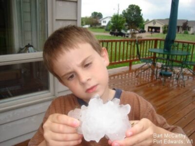
Figure 1. The second-largest hailstone on record in Wisconsin, which fell in Port Edwards (Wood County) in 2007. Picture courtesy of WAOW-TV.
Based upon the SPC archive, the four-inch diameter hail that fell last month would rank above more than 99.6 percent of all reported hail in this archive.
Hail reports are based upon observations made by the public with hail sizes either measured directly or estimated by comparison with the size of familiar objects.
Formation
Hail consists of balls of irregularly shaped lumps of ice that form within the updrafts of thunderstorm cells (Figure 2).
How large hailstones become depends upon the updraft speed within the thunderstorm cell updrafts, as higher speed updrafts are capable of supporting larger hailstones during their growth. The updraft speed also affects how fast the hail falls to the ground.
The 1921 record 5.7-inch hailstone would have encountered estimated updrafts of more than 100 miles per hour.
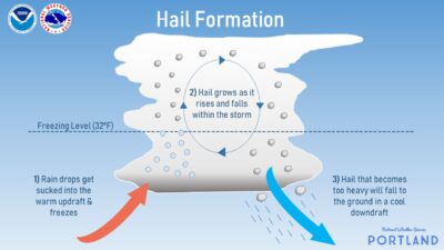
Figure 2. Diagram of hail formation within a thunderstorm made by the National Weather Service in Portland.
Hailstone size can range from peas to softballs when reaching the ground and can inflict damage to property and crops, as well as injuring or even killing animals.
In January 2010, the National Weather Service changed the threshold diameter for issuing severe thunderstorm warnings from 0.75 inches (penny size) to one inch (quarter size), based upon research that showed “significant damage” does not occur for hailstones smaller than one inch.
Additional factors involved in hail size include the vertical development of the updraft, the height of the freezing level, and the amount of supercooled water droplets entering the updraft from below the cloud, which can provide a water supply for ice layers to form around the original ice pellets.
Damage and Impact
During 2024, nearly two million dollars of damage caused by hail was reported in Wisconsin to SPC, with $1.278 million due to crop losses and $549,000 in property damage. The 2007 Port Edwards hailstorm resulted in approximately $45 million in damage to thousands of homes.
While no Wisconsinites have been killed by hail in the last 70 years, as many as 41 Wisconsinites have sustained injuries by hail between 1955 and 2023, with 30 of these injuries occurring near St. Nazianz (Manitowoc County) on May 12, 2000 when two-inch diameter hail combined with microburst winds exceeding 100 miles per hour damaged homes.
Frequency and Seasonality
Wisconsin typically experiences between 20 and 30 days per year when 0.75-inch or larger hail falls.
Luckily, most of the stones that fall are sufficiently small, so not much damage is reported; instead, most of the damage is caused by hail with diameters exceeding two inches. Over the last 30 years in the state, damage to crops due to large hail has occurred on approximately four days per year, while property damage has occurred on about six days per year.
Since large hail is produced by severe thunderstorms, the hail that falls across Wisconsin is seasonally dependent in a way similar to seasonal variations in thunderstorm activity. Slightly more than 84 percent of the large damaging hail falls during the warm half of the year (April through September), with the peak month for hail being in June (Figure 3).
This seasonal dependence in hailfall is caused by the increased presence of warm and humid air masses. Those air masses become destabilized due to intense daytime solar heating, along with cold air aloft that destabilizes the lower atmosphere to cause strong updrafts under the base of supercell thunderstorm cells.
Additionally, hailfall exhibits a diurnal variability, with nearly 35 percent of hail falling during the mid to late afternoon (2 to 6 PM CST), which corresponds to the “heat of the day”.

Figure 3. The monthly distribution of hail 0.75-inch in diameter or greater in Wisconsin from 1955 to 2024. Data from NOAA’s Storm Prediction Center.
Inspection of the annual hail reports for Wisconsin over the last 70 years indicates a general increase in the occurrence of hailfall from less than 30 per year before the 1980s to averages nearing 200 by 2020. The largest number of hail reports in a single year reached over 600 in 2007.
However, these numbers rely on citizen reports. While a significant increase in reports is seen, this could be due to several factors. For example, a rise in the public’s interest in weather, a growing understanding of the importance of local storm reporting, or city development creating more property susceptible to hail damage.
The number of “hail days” has also been increasing (Figure 4). Some of the increases in the daily occurrences of hail may be attributed to an increased number of storm spotters and increased monetary values of property and crops that could be damaged.
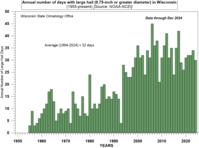
Figure 4. The number of days per year with hail 0.75-inch in diameter or greater in Wisconsin from 1995 to 2024. Data from NOAA’s National Centers for Environmental Information.
Geographic Distribution
Reports of large hail over the last seven decades tend to be more numerous across southern and central areas of the state, especially near large metropolitan areas. Northern areas, especially near Lake Superior and counties adjoining Michigan’s Upper Peninsula, have fewer hail reports (Figure 5). Some of this can likely be attributed to the fact that there are more people to observe and report hail in metropolitan areas as opposed to less populous regions.
Locations across southern and western areas of the state are more susceptible to thunderstorm activity that can become severe over a greater part of the season as warm, humid, and unstable tropical air masses spread northward across the region.
Northern sections of the state and those areas adjacent to Lake Michigan do not experience as many thunderstorms throughout a shorter summer season due to more frequent intrusions of polar air masses, and air flowing across the Lakes becomes stabilized by the cooler surface waters.
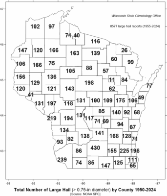
Figure 5. The number of reports of hail 0.75-inch in diameter or greater by county in Wisconsin from 1950 to 2025. Data from NOAA’s Storm Prediction Center.
This is a product of the Wisconsin State Climatology Office. For questions and comments, please contact us by email (stclim@aos.wisc.edu) or phone (608-263-2374).