Would you believe that the state of Wisconsin, located several hundred miles away from an ocean coastline, has its very own hurricane settlement?
Since 1844, a small unincorporated community in Grant County in southwest Wisconsin has been called Hurricane.
While the origin of the name remains unclear, the community’s encounter with a hurricane was highly unlikely. One possible explanation is the occurrence of a tornado in the area that early settlers described as having the strength of “hurricane-force” winds.
However improbable it may seem, Wisconsin isn’t completely immune to the impacts of hurricanes and tropical storms.
Tropical Cyclone 101
Tropical cyclones are intense low-pressure systems that form over warm ocean waters. These storms are referred to differently depending on their phase of development (Figure 1).
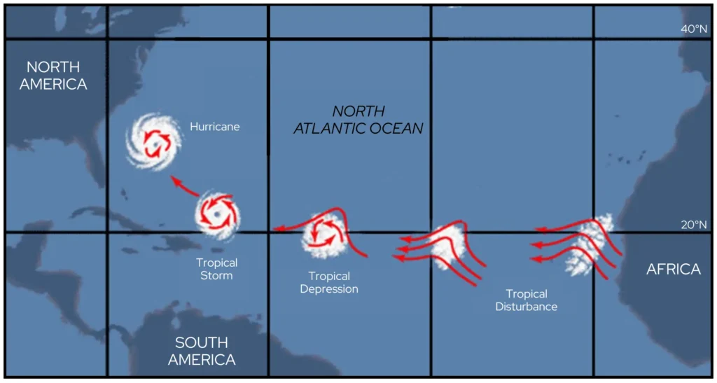
As a storm becomes organized, it’s called a tropical depression. Tropical depressions can mature into tropical storms and then into hurricanes. The Saffir-Simpson Hurricane Wind Scale is used to rank a hurricane’s strength from category 1 to 5. You may have also heard hurricanes referred to as typhoons or cyclones — it all depends on what ocean basin the storm forms in!
Tropical Cyclones in the Badger State
According to records from the NOAA Office of Coastal Management’s Historical Hurricane Tracks tool, four tropical cyclones have tracked across Wisconsin during the last 125 years (Figure 2).
Though these storms had lost much of their intensity and no longer qualified as hurricanes by the time they reached the Midwest, they still managed to bring torrential rain and gusty winds.
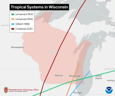
Galveston Hurricane (August 27-September 15, 1900)
The earliest documented encounter of a tropical system in Wisconsin was the infamous 1900 Galveston Hurricane, known as the deadliest natural disaster in US history.
The storm had weakened significantly by the time it reached Beloit (Rock County) on September 11 and moved across the southeastern sections of Wisconsin.
The storm brought rain and thunderstorms to the state, producing two inches of rain across the southern and central regions on September 10 and 11. The highest rain total was reported in Shawano (Shawano County), measuring 4.25 inches of rain in 24 hours. Reported wind speeds ranged from 20 to 40 miles per hour.
Texas Hurricane of 1949 (September 27 – October 7, 1949)
This unnamed hurricane in 1949 peaked as a Category 2 storm before reaching the Texas coast on October 4.
The remnants of the storm shifted over Kenosha County on October 6, then passed across Racine and Milwaukee Counties before heading out over Lake Michigan.
Though the center of the storm was located in southern Wisconsin, the bands of rainfall reached far to the north: over three inches of rain fell in Eau Claire and near Port Wing (Bayfield County). Winds across southern Wisconsin reached approximately 30 miles per hour.
Hurricane Gilbert (September 8 – September 20, 1988)
Hurricane Gilbert was an impressive and destructive storm that made landfall twice in Mexico before taking a turn toward the north. Gilbert weakened while trudging northeastward toward Illinois, and on September 19, moved over Lake Michigan, passing within 20 miles offshore of Kenosha.
Widespread torrential rain fell across the Badger State as the center of the storm system brushed by the lakeshore counties. Single-day rainfall totals ranged from one to five inches across western and northern Wisconsin.
Tropical Storm Cristobal (June 1 – June 12, 2020)
The most recent tropical system to have a direct impact on Wisconsin was former Tropical Storm Cristobal in June 2020.
Cristobal was still classified as a tropical depression when it reached the Mississippi River near Dubuque, Iowa, before crossing into Grant County. The center of the storm passed to the west of Madison, but still brought the capital city’s barometric pressure to a record monthly low of 29.2 inches of mercury (988.0 millibars).
Torrential rains, with totals ranging from one to five plus inches, fell across western Wisconsin on June 9 and 10, leading to significant rises on rivers and flash flooding. Wind gusts of 40 to 50 miles per hour were reported across the southern and eastern regions of the state, leaving thousands of residents without power.
Cristobal has the distinction of traveling the farthest northwest into the central states of any tropical system in recorded history!
Indirect Hits
Over the last 125 years, several other former tropical cyclones have passed several hundred miles to the south of the state, yet managed to provide Wisconsin with abundant rainfall.
The wettest remnant tropical cyclone was Hurricane Carla, which dumped 7.58 inches of rain at Brodhead (Green County) in September of 1961, with four to eight inches of rain in other areas of the state.
Hurricane Juan in October 1965 was responsible for 4.90 inches of rain falling at Marinette (Marinette County), and Tropical Storm Frances in September 1998 brought 3.75 inches to Darlington (Lafayette County).
Some 600 miles away from Wisconsin, Hurricane Sandy made landfall along the New Jersey coast in late October 2012. Despite the distance, the storm’s winds were strong enough to create near-record high waves on Lake Michigan!
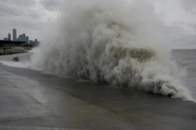
NOAA’s South Michigan buoy, located southeast of Milwaukee, reported wave heights reaching 21.7 feet on October 30, 2012. This was the second-highest wave recorded on the lake (the highest was 23 feet on September 30, 2011). The buoy measured 18-foot waves over ten consecutive hours that day, surpassing the record of seven hours set in October 1998.
Shoreline locations from Sheboygan to Kenosha experienced up to 30 mile per hour sustained winds, with gusts to 45. The high waves combined with the higher lake level caused minor beach erosion in Kenosha County.
Though more uncommon, a few eastern Pacific tropical systems have impacted Wisconsin.
One of these was the remains of Hurricane Newton in September 1986, whose remnants traveled across the Plains to provide southern Wisconsin with flooding rains and thunderstorms that caused wind damage from downbursts and tornadoes.