County Overview
Iron County is located in the northwestern part of Wisconsin, with Lake Superior bordering the county to the north. The land cover of Iron County is primarily forests, along with wetlands/open water and agricultural lands.
Some of the Ojibwe nation call Iron County home. The Bad River Ojibwe reservation is in northern Iron County and neighboring Ashland County, while the Lac du Flambeau Ojibwe reservation is in southern Iron County and neighboring Vilas County. The reservations were established by the 1854 Treaty of La Pointe, but the Ojibwe people had inhabited the area long before.
Iorn County has a humid continental climate, characterized by precipitation year-round and summers that are warm to hot. Lake Superior has a localized effect on Iron County’s climate, especially along the shores. The lake can moderate temperatures of northern Iron County, such as keeping things cooler during the day in summer and warmer during the night in winter. Lake Superior also plays a key role in other Iron County weather phenomena, such as lake-effect snow events and strong winds in fall.
Climate Averages
| Season | High Temperature | Low Temperature | Precipitation | Snowfall* |
|---|---|---|---|---|
| Winter | 23.7°F | 6.2°F | 4.8″ | 101.5″ |
| Spring | 50.2°F | 26.7°F | 8.7″ | 34.5″ |
| Summer | 75.2°F | 51.9°F | 11.9″ | — |
| Fall | 53.3°F | 34.3°F | 9.2″ | 24.7″ |
| Annual | 50.6°F | 29.8°F | 34.6″ | 160.7″ |
Averages for all variables in this table are computed for the most recent 30 years (1996-2025; Source: NCEI Climate at a Glance).
*Snowfall averages are computed by averaging station-level data, as NCEI does not provide county-level snowfall averages (Source: ACIS).
Seasons: Winter (Dec-Feb); Spring (Mar-May); Summer (Jun-Aug); Fall (Sep-Nov)
Climate Records
Hottest Recorded Temperature
100°F
(Saxon, July 16, 2006)
Coldest Recorded Temperature
-37°F
(Saxon, February 2, 1996)
Record 1-Day Rainfall
9.65″
(Saxon, July 12, 2016)
Record 1-Day Snowfall
26.0″
(Upson, March 13, 2006)
Records are computed using all available station data, some of which goes back to 1895 (Source: ACIS).
First & Last Freeze Dates
Average Last Hard Freeze
(28°F)
May 4
Average Last Freeze
(32°F)
May 16
Average First Freeze
(32°F)
September 28
Average First Hard Freeze
(28°F)
October 11
Averages for freeze dates are computed for the most recent 30 years (1996-2025; Source: ACIS).
Temperature
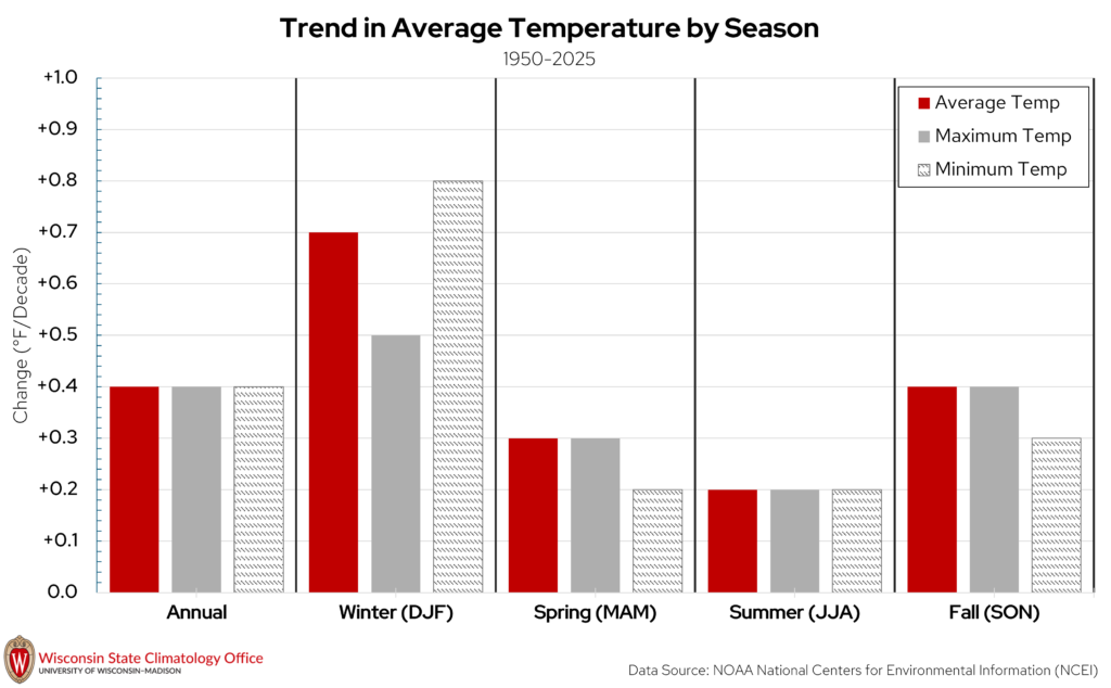
Temperatures have been increasing since 1950 in Iron County on the annual and seasonal time scales, which is the case for most of Wisconsin. Since 1950, annual average temperatures in Iron County have increased at a rate of 0.4°F/decade, which translates to an increase of 1°F every 25 years. This increase in temperature has been most pronounced in the winter months and less pronounced in the other seasons. In particular, winter minimum temperatures have been increasing by 1°F every 13 years since 1950.
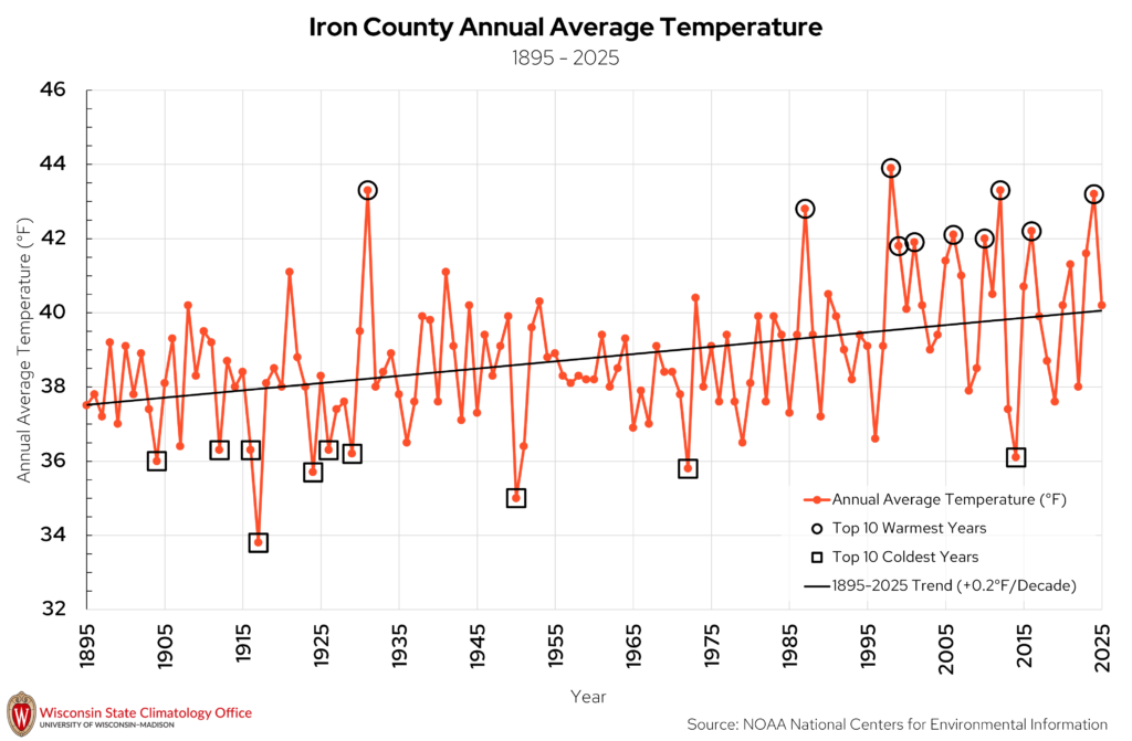
With temperatures warming, this does not mean that every year will be warmer than the last, or that more recent years will all have above-average (1895-2025) temperatures. However, Iron County is experiencing more years that are above average than it did in the past. For example, since 2000, Iron County has experienced only five years with below-average temperatures. Similarly, if we rank the top ten warmest years in Iron County since 1895 (black circles on the above chart), six have occurred since 2000, with 1998 and 1999 also in the top ten. The top ten coldest years (black squares) are a bit more clustered towards the earlier years in this time period, with nine of the top ten years occurring before 2000.
Precipitation
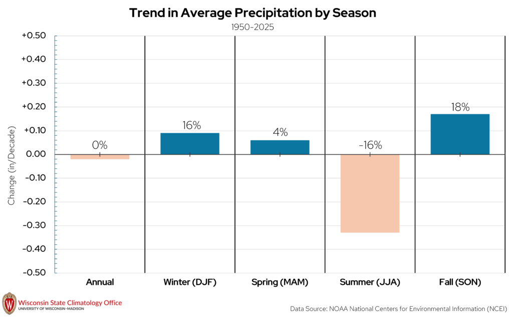
On the annual timescale, precipitation has shown minimal change in Iron County since 1950. Precipitation has decreased at a rate of 0.02″ per decade, which means a decrease of less then one inch every 100 years. This decreasing trend is different from most other Wisconsin counties, which have gotten wetter since 1950. At the seasonal level, summer is the season of largest decrease in precipitation in terms of inches per decade (-0.33″ per decade) and percentage (-16 percent) since the early 1950s. Conversely, fall is the season of largest increase in precipitation in terms of percentage (18 percent).
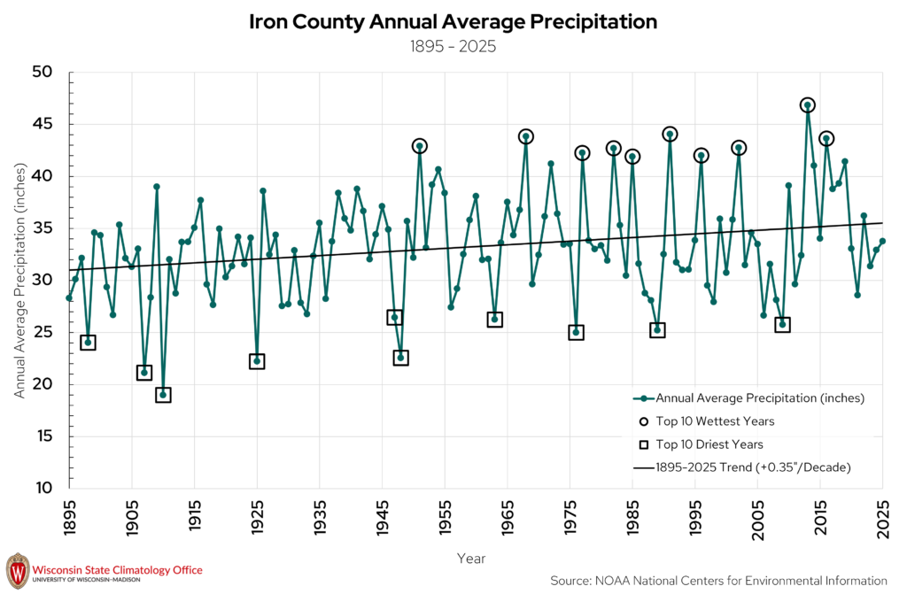
Looking at the full record from 1895 to 2025, annual precipitation has increased overall (one inch approximately every 29 years). However, as was noted in previous paragraph, there is a slight decrease if the trend starts in 1950. Taken together, the two graphs show that trends across shorter time periods can be more affected by the ups and downs in weather, pointing to the usefulness of long-term data sets when looking at climate trends. Even within the long-term trend that shows increasing precipitation, year-to-year precipitation varies. Since 2000, for example, the county has had three of its wettest years on record (2002, 2013, 2016), but it has also seen 12 years with below-average precipitation. This mix of wet and dry years is normal within a long-term trend.
Extreme Heat
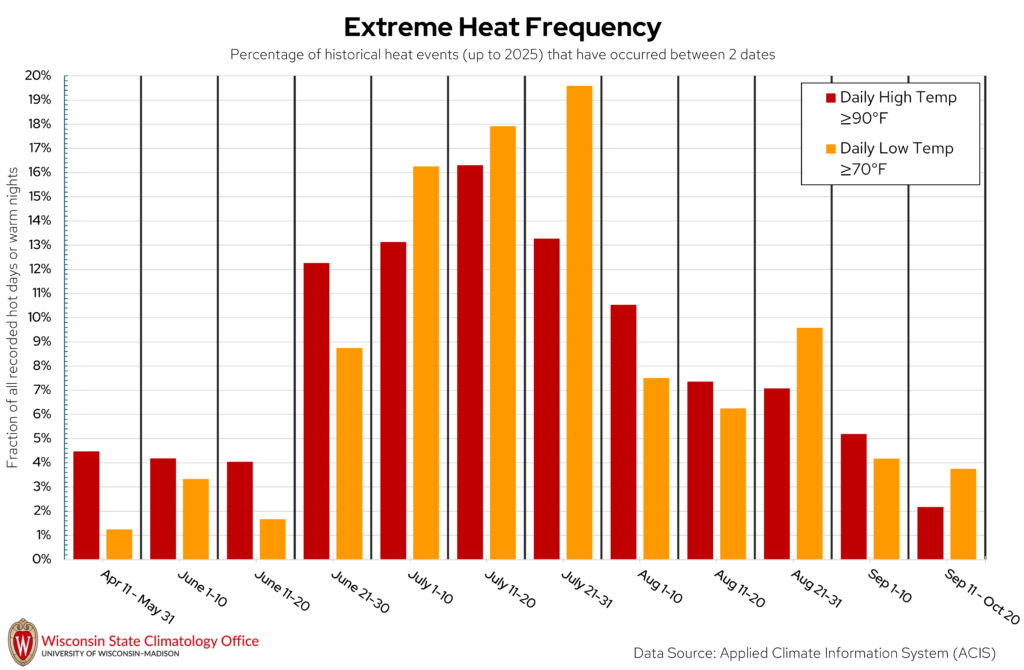
Iron County is no stranger to sweltering summer heat, where daytime temperatures can top 90°F or even 100°F. But when are these hot days most likely to occur in Iron County? The State Climatology Office analyzed the likelihood of a “hot day” (daily high temperature ≥ 90°F) or “warm night” (daily low temperature ≥ 70°F) occurring between two calendar dates using historical measured temperature data from NOAA stations in Iron County. Based on this analysis, hot days have occurred most frequently between July 11 to 20. Warm nights have been most common from July 21 to 31. Over the past 20 years (2006-2025), Iron County experienced, on average, five hot days per year and two warm nights per year.
Have Iron County summers been getting hotter? Since 1950, summertime average temperatures have warmed by 1.5°F, but have not warmed as much compared to other seasons in Iron County. Summertime high temperatures and low temperatures have been warming at similar rates (1.5°F). You can read more about trends in summertime temperatures in Wisconsin in this blog post.
Extreme Cold
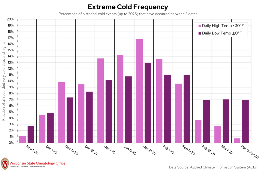
Iron County can get quite chilly once winter rolls around! Some of our coldest days of the year in Wisconsin are when the overnight low temperatures dip below 0°F. The State Climatology Office performed an analysis on the likelihood of a “very cold day” (daily high temperature ≤ 10°F) or “very cold night” (daily low temperature ≤ 0°F) occurring between two calendar dates using historical measured temperature data from NOAA stations in Iron County. Based on this analysis, very cold days and nights have occurred most frequently between January 21 to 31. Over the past 20 years (2006-2025), Iron County experienced, on average, 19 very cold days per year and 52 very cold nights per year.
Across all four seasons, winter has warmed the most in Iron County since 1950, a trend that holds true across most of Wisconsin. Since 1950, average winter temperatures in Iron County have warmed by about 5°F. Over this same time period, low temperatures in winter have warmed a bit more than the average temperatures (6°F).
Precipitation Extremes
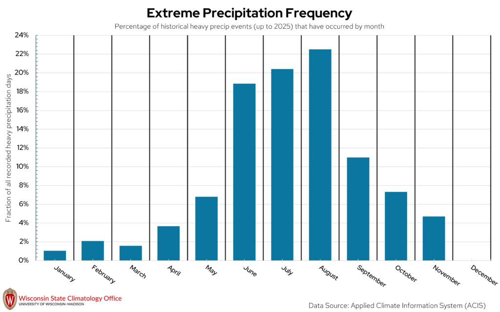
Heavy precipitation days, which for this publication refers to a one-day liquid precipitation total of two inches or more, can impact Iron County at all times of the year. Extreme precipitation in the winter is measured by the amount of liquid that would be present if you melted down all of the snow that fell that day. The vast majority of these heavy precipitation days (73 percent) have occurred from June through September. August is the month that has historically had the most heavy precipitation days in Iron County. In general, summer is the wettest season in Iron County, with winter being the driest season. Over the past 20 years (2006-2025), Iron County experienced, on average, nine heavy precipitation days per decade.
Hazards Summary
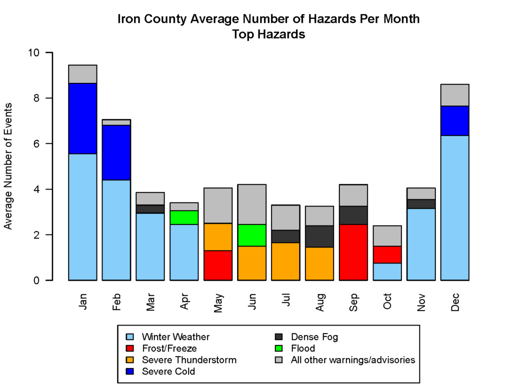
Iron County deals with an array of hazardous weather throughout the year, and the type of hazards vary from season to season. The bar chart and table above are summaries of warnings and advisories issued by the National Weather Service for Iron County over the past 21 years (2005-2025). Looking at hazards by month/season, the months of November through April are characterized by severe cold, snow events, and dense fog. Severe thunderstorms and flooding are more common in the late spring through summer. Frost advisories and freeze warnings are most common in May, September, and October as these are the times of year when we are transitioning into or out of the growing season, and plants are susceptible to frost. Dense fog advisories are most common from July through September. Overall, the most common hazards in a year in Iron County are winter weather, severe cold, and severe thunderstorms. Tornadoes are less common, with one tornado warning issued per every three years for the county, on average.
Hazard Type |
On average, how many does Iron County have each year? |
| Winter Weather | 26 |
| Severe Cold | 7 |
| Severe Thunderstorm | 6 |
| Frost/Freeze | 5 |
| Dense Fog | 5 |
| Flood | 4 |
| High Wind | 1 |
| Ice Accumulation | 0.9 |
| High Heat | 0.7 |
| Fire Weather | 0.4 |
| Tornado Warning | 0.4 |
Looking Ahead
Future climate projections from the Wisconsin Initiative on Climate Change Impacts (WICCI) indicate that by mid-century (2041-2060), under a moderate greenhouse gas emissions scenario, average annual temperatures in Iron County will continue to increase by approximately 4°F compared to recent averages. Winter is projected to continue to be the season of the largest temperature increase (about 5°F). The number of nights where temperatures drop below 0°F is expected to decrease substantially as winters warm (15-25 per year), and the number of nights in summer with temperatures staying above 70°F is expected to increase. The frequency of days that top 90°F is projected to increase with a warming climate to 15-20 days per year.
Annual precipitation is expected to increase by around five percent by mid-century, according to WICCI projections. This is a flip from the decreasing trend that has been observed up to present day. Winter and spring are projected to be the seasons of greatest precipitation increase in Iron County (about 10%), with summers projected to be 5% drier by mid-century. Despite projections for drier summers, the frequency of heavy precipitation days (two inches or more) is projected to increase by mid-century.
To explore more climate projections from WICCI and learn more about future climate modeling, please visit this website.
Want more information?
The data in this publication are a snapshot of the historical climate data for Iron County. If you have questions about this publication or would like more data on a topic, please contact the Wisconsin State Climatology Office.
For more information about how climate affects your farm, community, health, and livelihood, please check out resources from the Division of Extension and the Wisconsin Initiative on Climate Change Impacts.
Notes on Data Analysis
Daily data from meteorological stations were used in order to summarize the frequency of extreme heat, cold, and precipitation events in Iron County. Due to a lack of temperature data from NWS COOP stations in Iron County prior to 1940, data from a nearby COOP station in Ironwood, MI were included in the analyses.
The data source used for the analyses of annual and seasonal trends in temperature and precipitation was NCEI Climate at a Glance, which summarizes data at the county level using the nClimGrid dataset. The nClimGrid dataset is a gridded meteorological dataset, which estimates temperature and precipitation “on a grid” by statistically interpolating between meteorological stations in the county and adjacent to the county. Thus, nClimGrid is using measured data to estimate conditions at locations within the county not directly by a meteorological station, which helps paint a more complete picture of county-level averages and trends.