After an incredibly wet, hot, and humid end to June, it’s safe to say that most of us are hoping for a pattern change in July!
However, the official ‘dog days’ of summer begin on July 3 and continue through August, marking what’s usually the hottest period of the year for the northern hemisphere…so I wouldn’t get your hopes too high for any “refreshing” temperatures.
Temperatures
The Outlook: Another Warm One
Based on forecasts from NOAA’s Climate Prediction Center, Wisconsin has a chance of experiencing warmer-than-average temperatures in July.
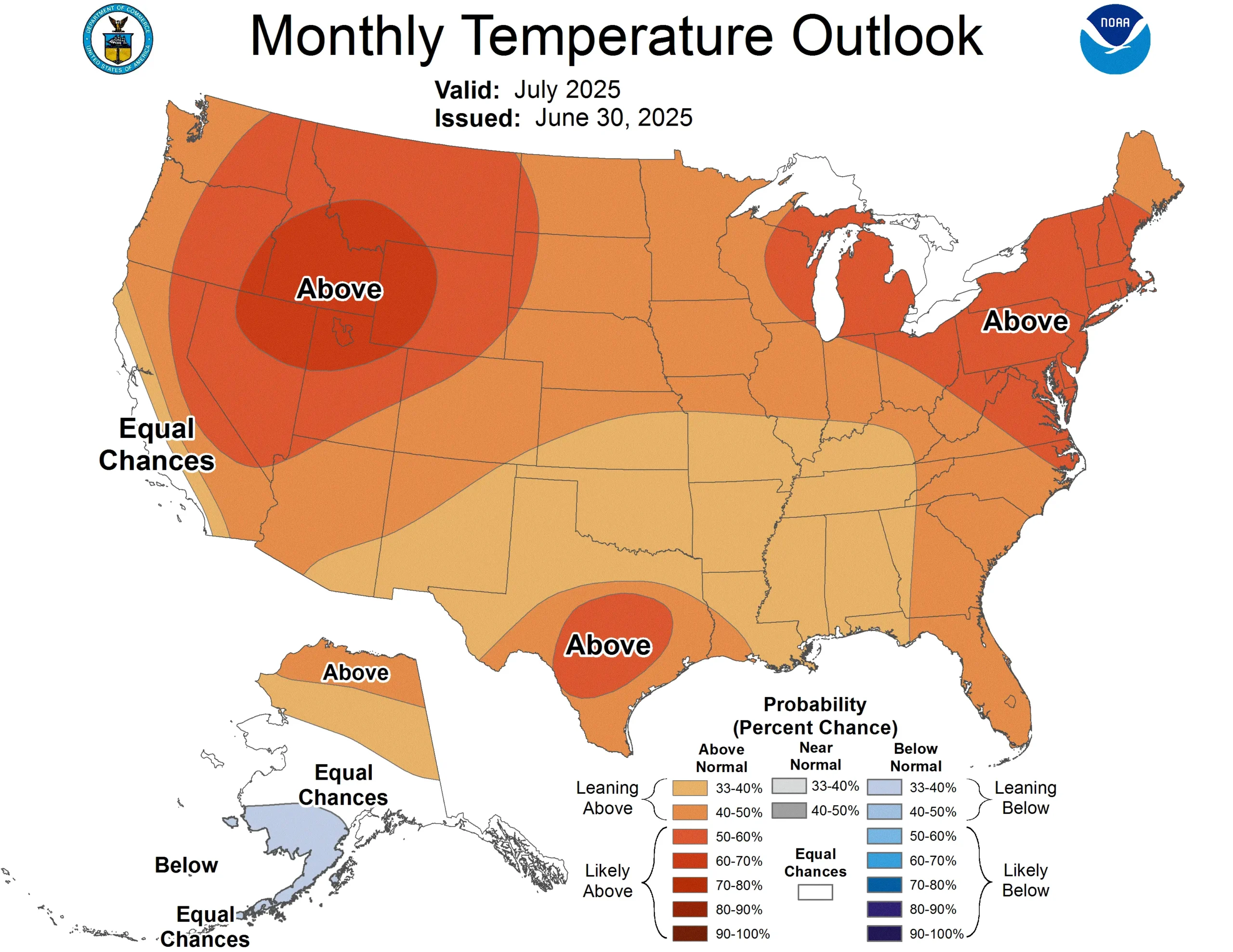
Note that the colors of the above map indicate the probability of above or below average temperatures, not the intensity of the expected warmth or cold. Western Wisconsin is highlighted as having about a 40 to 50 percent chance of warmer-than-typical temperatures. Eastern Wisconsin has slightly higher chances of warmer weather, at 50 to 60 percent. Check out this blog for more information on deciphering climate probabilities.
The Averages
Wisconsin’s average high temperature in July is 80.4°, typically making it the hottest month of the year! We can narrow it down even further: July 19 is historically the hottest day of the year, with a statewide average high temperature of 82.2°.
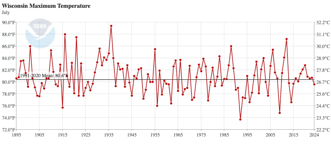
By high temperature, the hottest July on record was in 1936 with a statewide average high of 89.4°. In the depths of the Dust Bowl, many of the state’s hottest temperatures were reached in that month; most of those records have yet to be beaten. Eau Claire, Wausau, Madison, and Green Bay’s hottest temperatures were set in July 1936, during what was a five to ten day stretch of 100° weather for much of the state.
By average temperature (accounting for both high and low temperatures), the hottest July was 1921 with an average temperature of 75°. Also by average temperature, the coolest July on record was in 1992 when the average temperature was a chilly 63.3°.
Precipitation
The Outlook: To Be Determined
Similar to last month, there is no strong signal toward an especially wet or especially dry July; the Climate Prediction Center is forecasting equal chances for above, near, or below average rainfall in Wisconsin.
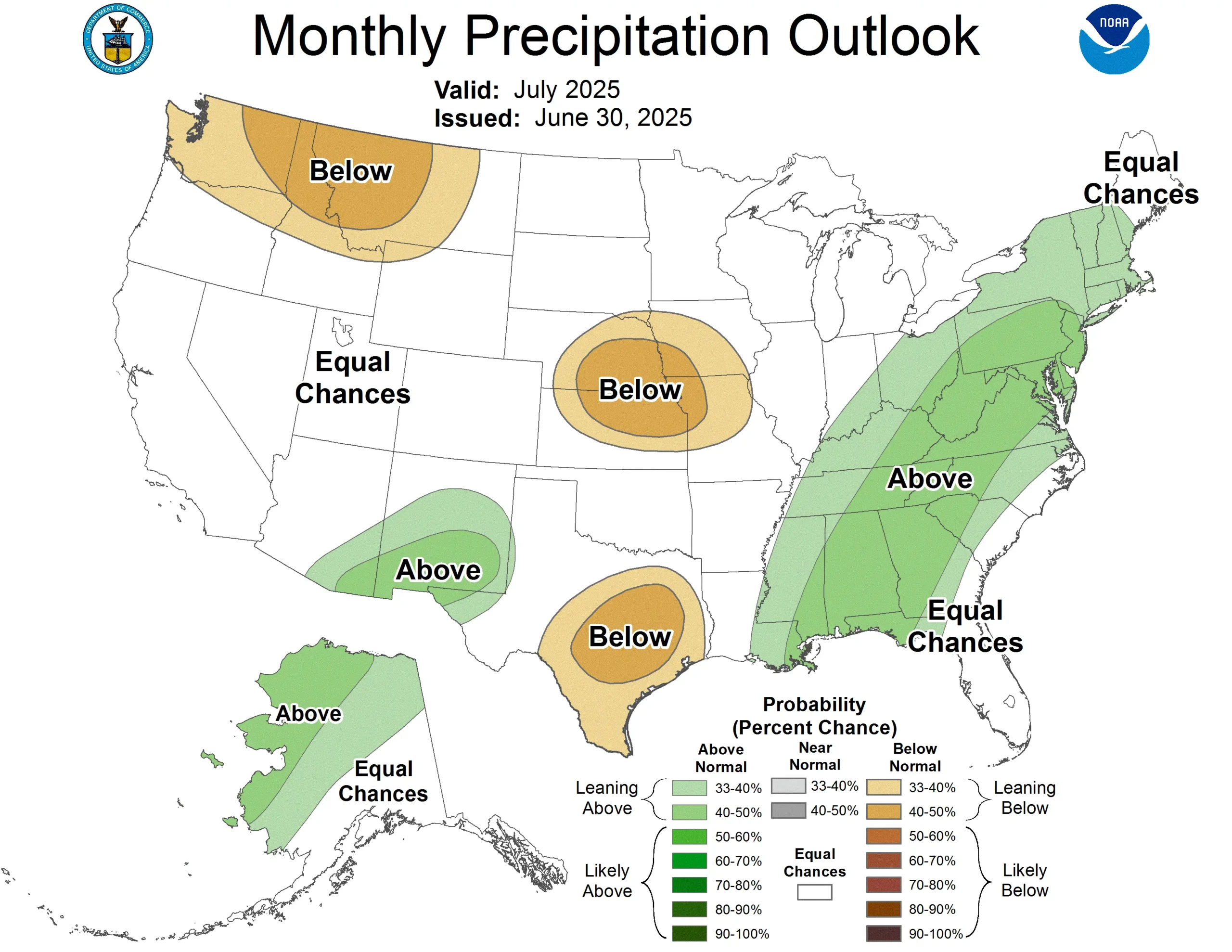
However, if you are making plans for the early part of July, the six-to-ten day outlook suggests that Wisconsin could continue with June’s rainy trend and lean slightly wetter than average.
The Averages
The state usually begins to grow drier during July; that trend increases as the fall season approaches. With an average of 4.04 inches of rainfall, July is typically between a half-inch to three-quarters of an inch drier than June.
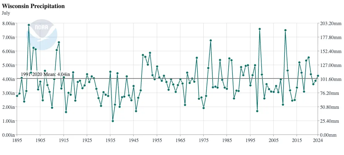
The wettest July on record in Wisconsin was shortly after records began in 1900 — the statewide average came in at 7.88 inches! In more recent years, July 2010 came close to that record with an average of 7.50 inches of rain.
July of 1936 wasn’t just the hottest July on record in Wisconsin, but also the driest, with only 0.99 inches of rain on average across the state. Eau Claire measured barely over a tenth of an inch that month!
| Location | Wettest July on Record | Driest July on Record |
|---|---|---|
| Milwaukee | 10.93″ in 2010 | 0.28″ in 1936 |
| Madison | 10.93″ in 1950 | 0.29″ in 1909 |
| La Crosse | 11.03″ in 1883 | 0.16″ in 1967 |
| Green Bay | 9.51″ in 2010 | 0.70″ in 1946 |
| Eau Claire | 8.88″ in 1900 | 0.12″ in 1936 |
| Wausau | 13.02″ in 1900 | 0.94″ in 1937 |
This is a product of the Wisconsin State Climatology Office. For questions and comments, please contact us by email (stclim@aos.wisc.edu) or phone (608-263-2374).