Wisconsin caught a severe case of mid-March weather whiplash: a historic blizzard dropped over two feet of snow on the state less than a week after many locations reached their first 70-degree temperatures of the season.
The Storm Brews
A strong storm system developed in the Rockies — dubbed a Colorado Low — and tracked across the Central Plains and Midwest. The storm continued to strengthen as it raced across the central United States.
Concerns of record-breaking snowfall and major travel impacts grew. The National Weather Service issued blizzard warnings for the entire state of Wisconsin, as winds of 50 to 60 miles per hour were expected to create whiteout conditions. For the cities of Milwaukee and Madison, this was the first blizzard warning in over a decade, and the first on record in the month of March.
Wisconsin Governor Tony Evers declared a state of emergency, urging residents to stock up on essentials and prepare for power outages.
The Storm Arrives
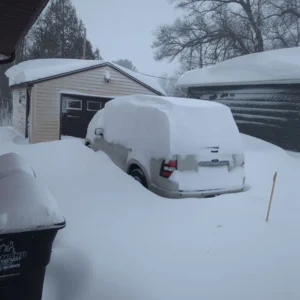
The storm reached the western parts of Wisconsin on the evening of Saturday, March 14. Overnight, it progressed through the central parts of the state, with the main snowband setting up from Black River Falls to Wausau to Green Bay. By Sunday morning, over 20 inches of snow had fallen in parts of these regions.
However, warm air in southern Wisconsin created a very different scene. Rain, sleet, freezing rain, and even small hail fell overnight through the morning of Sunday, March 15, as thunderstorms rumbled through.
A lull in activity on Sunday afternoon gave some Wisconsinites a chance to make a dent in their shoveling before the second round arrived later that evening.
In this round, it was snow for everyone, accompanied by gusty winds. This second snowband set up slightly south of the first one, stretching from Madison to Wausau and Green Bay.
Snow had ended by midday on Monday, March 16, but powerful winds kept visibility low and pushed snow back over the roadways.
By the Numbers
From March 14 to 16, over 25 inches of fresh snow fell on parts of the state. The heaviest snow fell from north of La Crosse to Wausau, Green Bay, and Door County.
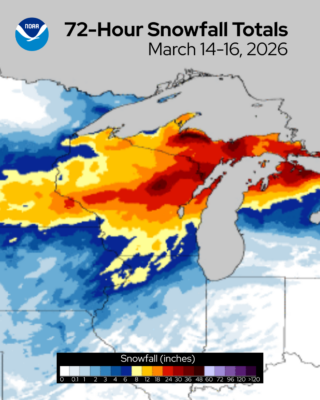
Remote Sensing Center, showing the significant snow totals that fell across Wisconsin from March 14 to 16, 2026.
The highest snow totals that were reported came from Door and Shawano counties. Both the city of Shawano and Egg Harbor measured 33 inches of snow from the event.
The community of Upson still holds the state record for the largest single-day March snowfall with 26.0 inches on March 13, 2006. Neillsville in Clark County still holds the all-time state record for the largest single-day snowfall.
Wausau measured a total of 30.9 inches from the event, making it the city’s largest snowstorm on record! Of that total, 23.4 inches fell on March 15 alone, becoming Wausau’s snowiest day on record (the previous record was 15.7 inches that fell on February 12, 2019).
Green Bay weathered its second-largest snowstorm on record, with a total of 26.6 inches. Just over 17 inches had fallen on March 15, marking the city’s third snowiest day. Green Bay’s two snowiest days had occurred in 1888 and 1889, so it had been over a century since the area had experienced a snowstorm of this size!
Eau Claire set a new daily snowfall record for March 15 with 8.7 inches, surpassing the previous record of 4.2 inches set in 1974.
With a total of 7.2 inches of snow, La Crosse also broke their daily record for March 15, which was previously 6.0 inches in 1923.
Snowfall in the capital city was split between two days, with 5.6 inches falling on March 16. This broke Madison’s previous record for the date of 3.5 inches set in 2006.
| Location | Total Snow (Inches) for March 14-16, 2026 | Largest March Snowstorm on Record (Snow Total in Inches) |
|---|---|---|
| Wausau | 30.9 | March 14-16, 2026 (30.9) |
| Green Bay | 26.6 | March 1-2, 1888 (29.0) |
| Eau Claire | 12.7 | March 29-30, 2006 (16.5) |
| La Crosse | 9.9 | March 5-6, 1959 (18.5) |
| Madison | 8.1 | March 18-19, 1971 (14.5) |
| Milwaukee | 4.8 | March 3-4, 1881 (25.5) |
You can find more local storm reports from the National Weather Service offices in Green Bay, Milwaukee, La Crosse, the Twin Cities, and Duluth.
Obtaining accurate snow measurements was a challenge, as the wind gusts over 50 miles per hour swept the fluffy snow into large drifts. Milwaukee, Racine, and Fond Du Lac all measured gusts of 60 miles per hour on March 16.
The Impacts
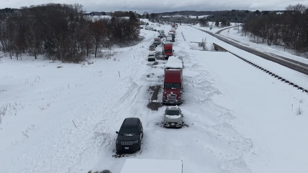
Travel conditions deteriorated rapidly as the storm progressed through the state. Roads quickly became covered, and snowplow crews struggled to keep up with snow that was falling up to three inches per hour. In the Green Bay area, some municipalities suspended plowing during the worst of the storm to keep plows from becoming stuck.
By the afternoon of March 15, travel was not advised in central and northern Wisconsin. Interstates came to a standstill, stranding drivers for four to five hours. Over 160 motorists were stuck in Outagamie County alone. Drifts of three to five feet were common on open roadways; 12-foot drifts were even seen in Door County, closing a state highway for days.
Over 15,000 users were reported to be without power due to the storm. Crews battled the wind and snow-covered roads to restore power for most of the state by the evening of March 16.
This major storm served as a reminder that though Wisconsin’s climate has been warming — so much so that March has effectively shifted from a winter month to a spring one — extreme winter weather events can still occur, even at unusual times.
This is a product of the Wisconsin State Climatology Office. For questions and comments, please contact us by email (stclim@aos.wisc.edu) or phone (608-263-2374).