November delivered the drama expected of a transitional month: near-record warmth in the first half of the month gave way to winter’s icy grip by month’s end, with drought-relieving rains in between.
Warm Start, Frosty Finish
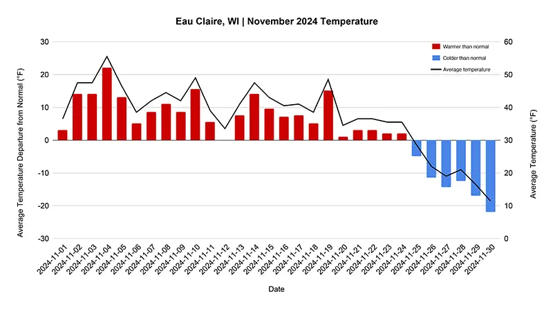
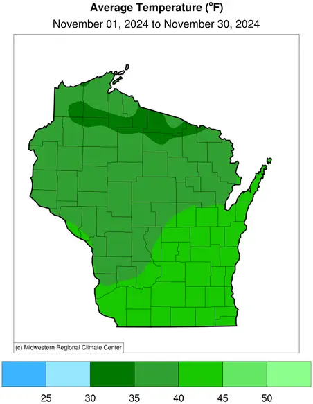
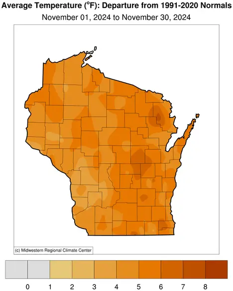
As we transition from fall to winter, Wisconsin typically experiences dramatic temperature swings, and this year was no exception. A striking shift occurred around November 25, marking a stark change from above-normal warmth to a frigid end of the month (Figure 1). The notably warm first three weeks of November contributed to the month’s statewide average temperature of 38.7 degrees Fahrenheit —an impressive 5.3 degrees above normal (Figure 2). This ranked as Wisconsin’s seventh warmest November on record.
The warmth culminated in several locations reaching the month’s warmest temperature of 70 degrees, including Green Bay on November 4 and Montello and Appleton on November 5. This early-November heat was accompanied by unusually high dew points, indicating a very humid air mass. In Madison, the dew point climbed to 62 degrees on November 5, nearing the record for the highest November dew point (64 degrees) set in 1958 and 1961.
By late November, however, a sharp cold front ushered in winter-like conditions. The coldest temperature of the month, 0 degrees, was recorded in Luck, Polk County, on November 30. This drastic shift also brought an end to the frost-free season across Wisconsin’s six First Order Stations (Milwaukee, Madison, Green Bay, Wausau, Eau Claire, and La Crosse). Milwaukee’s temperature dropped to 32 degrees on November 20, marking the season’s first frost over a month later than the median date of October 18.
A Wet Turn of Events
November brought a distinct change from the dryness of September and October, with the state seeing its 11th wettest November on record. Wisconsin recorded a statewide average precipitation of 3.42 inches, which is 1.43 inches above normal or 172 percent of normal (Figure 3).
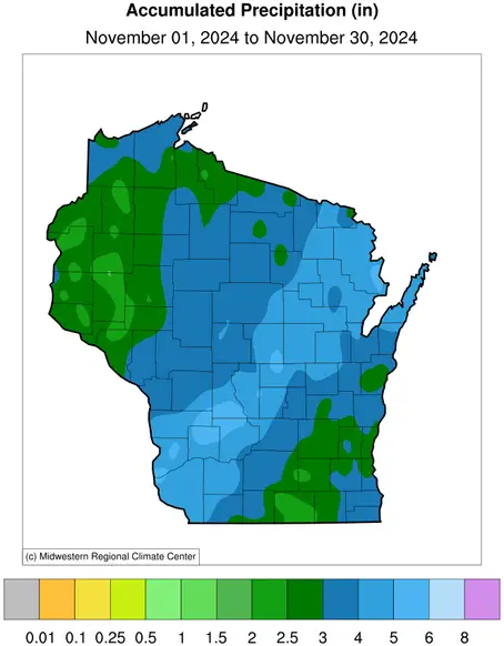

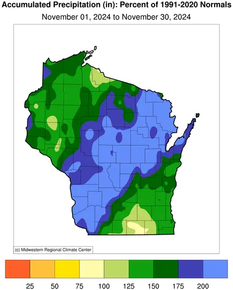
In fact, some 20 Wisconsin counties saw over 200 percent of their normal November precipitation. Wausau in Marathon County had 12 days of measurable precipitation totaling 3.39 inches, most of which fell in the first week of the month (Figure 4).

Additionally, on November 4, Benton in Lafayette County reported 2.19 inches of rain, which was the highest statewide 24-hour precipitation total for the month and is 92 percent of Lafayette County’s average November rainfall.
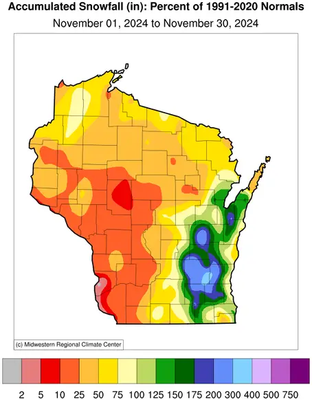
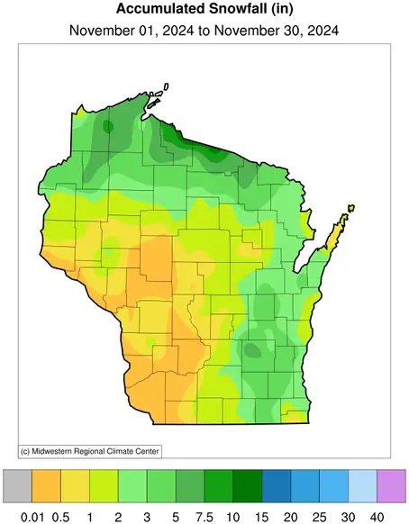
By late November, the rain transitioned to snow as colder air moved in. November 20 and 21 marked the season’s first measurable snowfall for five of Wisconsin’s six First Order Stations, occurring roughly 10 days later than their median first snowfall. The La Crosse Regional Airport was the exception, only seeing traces of snowfall throughout November. Remarkably, several other stations in Wisconsin saw 5 inches of snow between November 21 and 22, particularly in east-central to southeastern Wisconsin (Figure 5). As a result of this event, areas from Green Bay down to Walworth County ended November with an impressive 150 percent of normal snowfall and even 300 percent of normal in southeastern Dodge County (Figure 6).

Furthermore, a robust snow plume generated by steam from a factory near Menomonie in Dunn County on Thanksgiving Day created localized hazardous conditions, including slippery roads on I-94 and USH 53. Ten miles of westbound lanes were completely shut down for about three hours, and multiple crashes made for a busy holiday for tow truck companies.
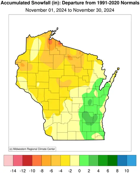
Despite the aforementioned wintry conditions, hardly enough snow fell to make a dent in the normal amount Wisconsin sees in November (Figure 7). The western half of the state saw what felt like nothing more than a flurry, and the Lake Superior snowbelt lacked big time. Normally, 21.5 inches of snow falls in Hurley (Iron County) in November. But by the end of the month, Hurley reported an underwhelming 10 inches as the state’s highest snow cover of the month.
Drought Improvement for Most
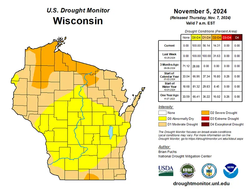
November marked a significant turning point for Wisconsin’s drought conditions. The month began with all of the state in drought, as reported in the October 29 U.S. Drought Monitor release. However, a series of widespread and heavy rainfall events during the end of October and early November rapidly improved conditions, reducing drought coverage to just over half of the state a week later (Figure 8).
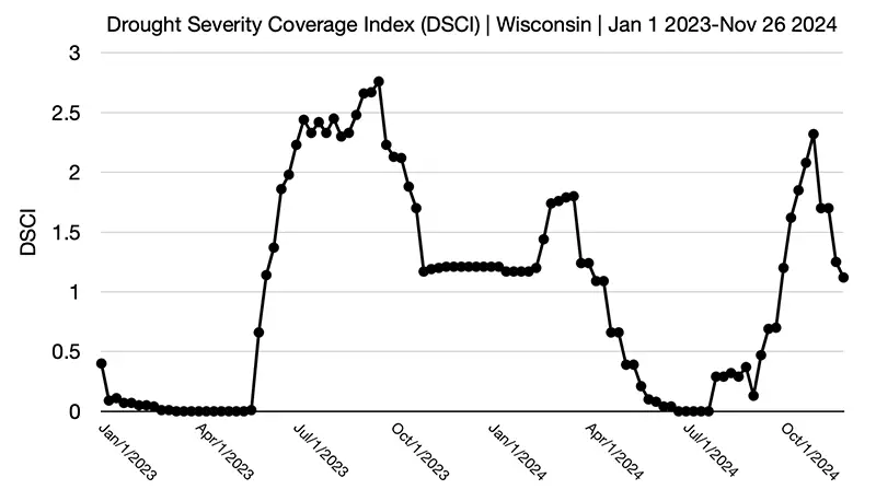
This dramatic shift is reflected in the sharp drop in the Drought Severity Coverage Index (Figure 9). Unfortunately, while Wisconsin saw notable improvements, drought remained a widespread issue across the country. As of November 5, a record-breaking 87.78 percent of the nation was classified as abnormally dry.
Persistent rainfall throughout November continued to chip away at drought across Wisconsin. By the end of the month, 41 percent of the state remained in moderate drought and less than 4 percent was classified as experiencing severe drought (Figure 10). For many areas that received replenishing precipitation, the concerns associated with drought—such as dry soils, low streamflow, depleted water levels, and stressed lawns and pastures—were significantly alleviated.
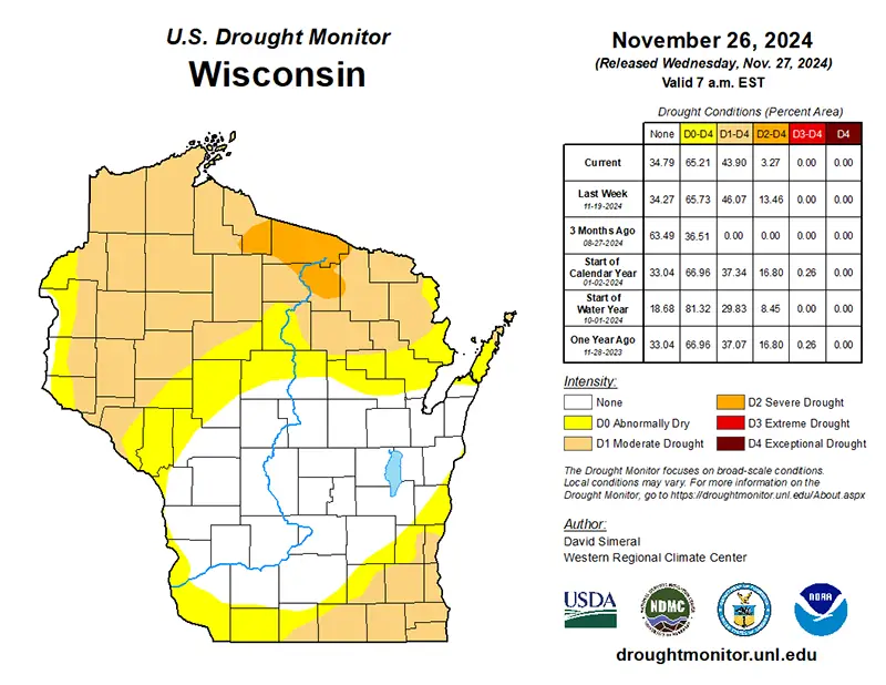
Despite the progress, some regions in Wisconsin continue to grapple with lingering drought. Northern Wisconsin, which has been in drought since mid-September, and far southern Wisconsin, affected since mid-October, saw slower recovery. These areas are still experiencing drought concerns, reflecting the long-lasting impacts of prolonged dry conditions.
Outlook
As Wisconsin prepares for the heart of winter, the seasonal outlook for December through February is a bit complex. The latest NOAA Climate Prediction Center update suggests that La Niña development remains possible this winter, although the likelihood and expected strength have weakened compared to earlier projections. This uncertainty has led to what we might call a “La Niña Mañana” scenario—a waiting game to see if the pattern will truly take hold. If La Niña does form, its impacts are typically most noticeable between January and March. Historically, weak La Niña winters in Wisconsin have brought above-normal snowfall to the northern half of the state. However, it’s important to remember that other factors, such as variability in our weather and the effects of our long-term climate trends, also influence our overall conditions.
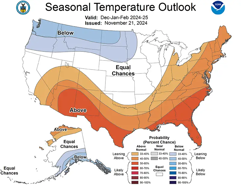
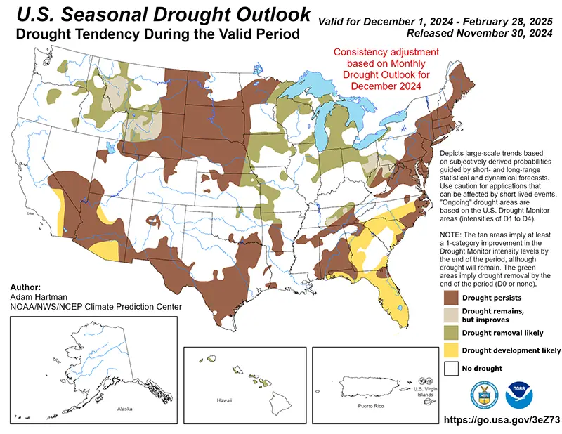
For now, we can say that over the next three months, Wisconsin has equal chances of experiencing above, near, or below normal temperatures, while chances are tilted slightly towards above-normal precipitation (Figure 11). With a slight favor toward wetter conditions, drought improvement and removal is likely on the horizon (Figure 12).

Climate Corner
Q: Will Wisconsin “Let It Snow” this winter?
A: ‘Tis the season to be thinking about snow. November is usually the first month with significant snowfall in Wisconsin after the waning warmth of autumn loses its grip. And traditional scenes of the winter holiday season are replete with snow cover. However, snowfall in our region is notoriously fickle from one year to the next. Only two winters ago, Wisconsin was buried with a record-high 81.5 inches of statewide-averaged snowfall that fell from November to May, yet the snow drought last winter left most of the state green (or brown), even in northern Wisconsin.
The State Climatology Office keeps records of Wisconsin’s snowfall back to the 1890s. The data suggest that our state has been getting considerably snowier over time, including a few exceptionally white winters this century. But there are reasons to question this trend, because official snowfall measurement methods nowadays are different from those used many years ago. Assessing Wisconsin’s snowfall record is a current research activity in our office.
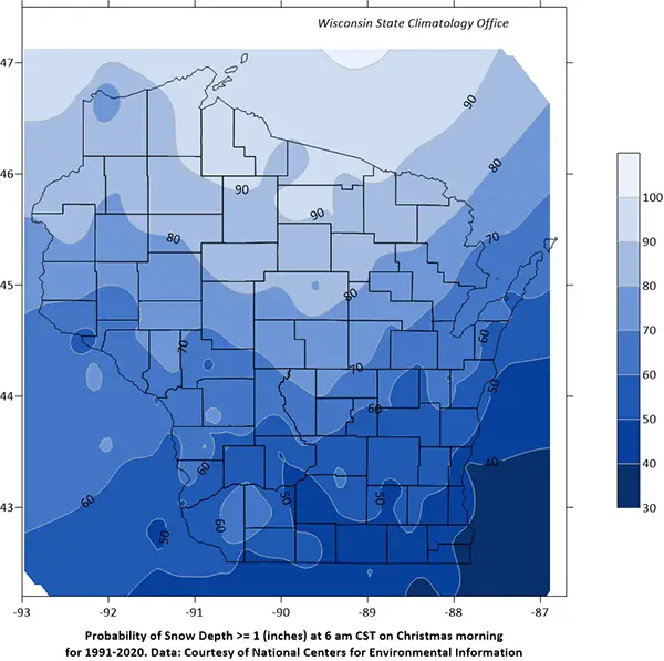
For those who celebrate Christmas, many wish for (and “dream of”) a white Christmas, which is defined as at least one inch of snow cover on the morning of December 25. Not surprisingly, locations in northern Wisconsin have the greatest likelihood of a white Christmas (exceeding 90 percent), while far southern and southeastern Wisconsin have less than a 50-50 chance, based on the most recent climate normal period from 1991-2020. The deepest holiday snowpack ever reported was a whopping 47 inches in Luck, Wisconsin (Polk County), in 1983 (Figure 13).
Steve Vavrus is the Wisconsin state climatologist. Bridgette Mason and Ed Hopkins are the assistant state climatologists.