The polar vortex is often talked about whenever a cold spell strikes, while in reality, it’s an atmospheric feature that exists throughout the entire winter season. Wisconsin is occasionally impacted by the Arctic polar vortex, which is centered over the North Pole, though there is an Antarctic polar vortex over the South Pole. In this discussion, we’ll just focus on the Arctic polar vortex.
Vortex vs. Jet Stream: What’s the Difference?
The polar vortex refers to a center of low pressure that swirls in the stratosphere (about 10 to 30 miles above the ground) around the North Pole during the winter. Inside the vortex is extremely cold Arctic air. The colder the air in the vortex, the faster the vortex tends to spin.
The polar jet stream is a river of wind that flows from west to east about five to nine miles above the ground. The polar jet stream is typically north of Wisconsin and helps keep the Arctic air contained near the North Pole.
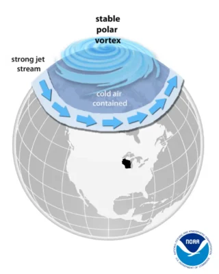
When the Vortex is Stable…
When the polar vortex is stable and strong, the polar jet stream usually stays strong as well. This traps the icy air up north, restricting its impact on Wisconsin. Think of it like swirling a lasso: when you spin it quickly, it creates a nearly perfect circle. In this case, the jet stream is lassoing the cold air.
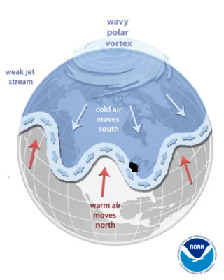
When the Vortex is Unstable…
Sometimes temperatures high up in the atmosphere warm up suddenly, causing the polar vortex to weaken. This is called sudden stratospheric warming. During these events, the vortex slows down, often shifts away from the North Pole, and can even split in two. As a result, the polar jet stream may also become unstable, and allow Arctic air to slip south — sometimes into Wisconsin. Bringing back the lasso analogy, when it’s spun slowly, the rope becomes wavy.
The Coldest of the Cold
Arctic pools of air are typically responsible for Wisconsin’s most extreme cold conditions. An outbreak of Arctic air in February 1996 resulted in Wisconsin’s all-time coldest temperature on record: minus 55 degrees Fahrenheit in Couderay (Sawyer County).
In more recent years, the Arctic blasts of January 2014 and 2019 stand out in memory. Two bouts of arctic air struck in January 2014, dropping temperatures in Wisconsin to 30 degrees below zero and wind chills to 40 below!
A similar temperature plunge was seen at the end of January 2019, but stronger winds made for even colder wind chills. Feel-like temperatures of 50 below zero were common across the state. A minus 60 degree report from Menomonie (Dunn County) made for Wisconsin’s coldest wind chill on record.
Bracing For the Cold
Even though Wisconsin is a cold-weather state, it’s important not to underestimate the dangers of the cold. Frigid air from the Arctic can cause frostbite and hypothermia that can turn deadly.
According to the Wisconsin Department of Health Services, an average of 60 cold-related deaths occurred in the state each winter since 2015. Stay inside if temperatures reach dangerous levels. Always dress for the cold when you do have to venture out, and have an emergency kit ready just in case.
This is a product of the Wisconsin State Climatology Office. For questions and comments, please contact us by email (stclim@aos.wisc.edu) or phone (608-263-2374).