
Crisp, fall-like temperatures gave way to summer-like warmth, scattered rainfall did little to ease expanding dry conditions, and harvest activity picked up, all leaving their mark on September in Wisconsin.
False Fall to Summer’s Return
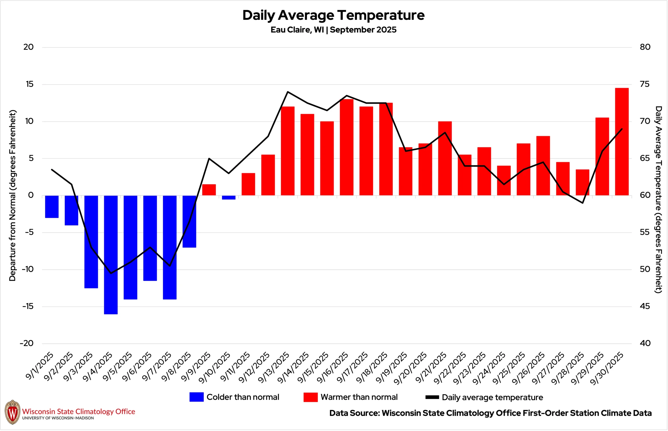
September delivered a dramatic two-act performance, with a taste of fall in the first week quickly giving way to a late-month return of summer (Figure 1).
Taste of Fall
Canadian air plunged into the region from September 3 through 8, sending temperatures well below normal. Each of Wisconsin’s six first-order weather stations saw daily averages that ran 10 or more degrees below normal for four to five days.
The early chill produced a cascade of records: at least 10 stations set or tied record cold highs on September 4, and at least another 11 did so on September 5 (Tables 1 and 2).
| Location | High Temperature (°F) on September 4, 2025 | Previous Cold High Record |
|---|---|---|
| Rhinelander | 54 | 58 (2008) |
| Merrill | 55 | 56 (1905) |
| Antigo | 55 | 56 (1896) |
| Marshfield | 57 | 60 (1935, 2008) |
| Wausau | 57 | 59 (1905) |
| Stevens Point | 58 | 58 (2008) |
| Sturgeon Bay | 59 | 59 (1934) |
| Green Bay | 61 | 61 (2008) |
| Oshkosh | 62 | 62 (2008) |
| Manitowoc | 63 | 63 (1896, 1918, 2010) |
| Location | High Temperature (°F) on September 5, 2025 | Previous Cold High Record |
|---|---|---|
| Antgio | 53 | 56 (2017) |
| Ashland | 53 | 56 (1926) |
| Rhinelander | 54 | 55 (2017) |
| Marshfield | 55 | 61 (2017) |
| Merrill | 56 | 58 (2017) |
| Wausau | 56 | 57 (1956) |
| Wisconsin Rapids | 57 | 59 (1956) |
| Eau Claire | 58 | 60 (1933, 1956) |
| Oshkosh | 58 | 61 (1988) |
| Green Bay | 59 | 60 (1981) |
| Appleton | 59 | 61 (1981, 2010) |
La Crosse tied a record low of 40 degrees on September 7, which was previously hit in 1956, 1986, and 2024. National Weather Service La Crosse highlighted this impressive feat:
This was only the fourth daily cold record (coldest high or coldest low) this century [in La Crosse]. In contrast, there have been 59 daily warm records (record high or warmest low) this century.
Wisconsin also saw temperatures in the 30s on these chilly mornings. Some of the season’s first temperatures at or below freezing were recorded between September 7 and 9. The Black River Falls (Jackson County) Wisconet station, the Superior Airport (Douglas County), and Fort McCoy (Monroe County) were a few that recorded 32 degrees. The Hayward Airport (Sawyer County) recorded the month’s coldest reading of 31 degrees on September 8.
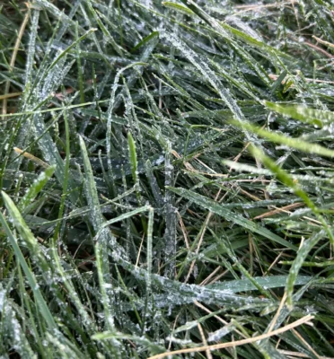
Astonishingly, Fort Atkinson (Jefferson County) reported a light frost on September 4, nearly a month ahead of the county’s typical October 1 first-frost date (Image 1).
Summer Strikes Back
The cool pattern broke quickly, and by mid-September, summer returned in force. Eau Claire logged nine days at least 10 degrees above normal during the second half of the month, and Madison and Wausau notched eight such days.
Several 80-degree or hotter days punctuated the warm stretch, including 13 such days throughout the month in Madison — eight of them consecutive (Table 3). Normally, Madison only sees eight such days. However, these warm September temperatures have become more common in recent years, including last September when Madison saw 12 consecutive 80-degree days.
| September Days with High Temperature ≥80°F | |||
|---|---|---|---|
| Location | 2025 Count | 1991-2020 Normal Count | Longest Consecutive Stretch in 2025 |
| Madison | 13 | 8 | 8 |
| La Crosse | 12 | 10 | 8 |
| Eau Claire | 9 | 8 | 7 |
| Wausau | 7 | 5 | 5 |
| Green Bay | 6 | 6 | 4 |
| Milwaukee | 3 | 7 | 2 |
La Crosse tied its daily high-temperature record of 87 degrees on September 29 (previously set in 1898), and Rhinelander broke its record with 82 degrees (previously 81 degrees in 1948). The hottest temperature of the month was a sizzling 92 degrees in Wausaukee (Marinette County) on September 18.
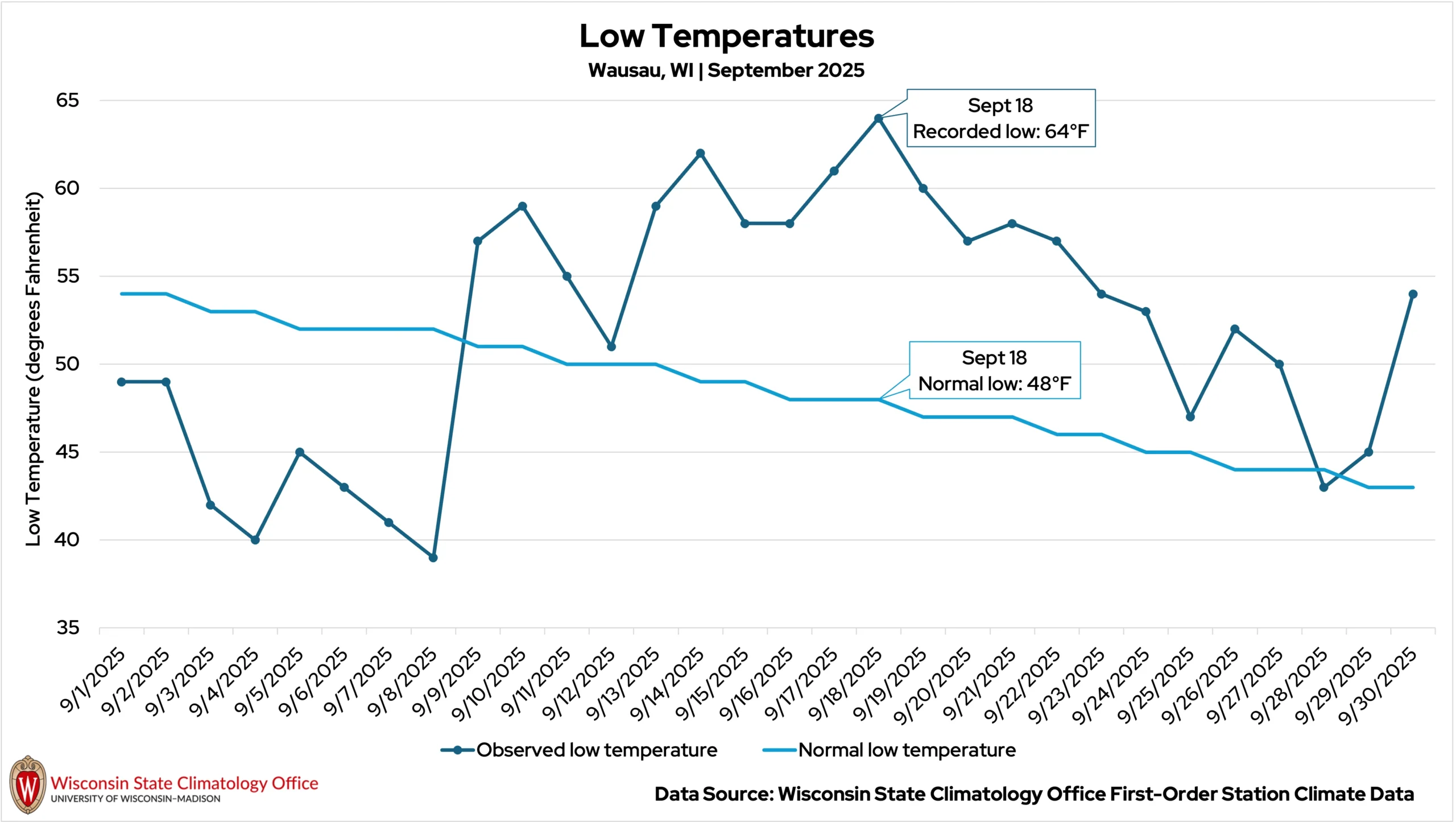
Overnight temperatures were remarkably warm for September. The statewide average minimum temperature for the month was 51.2 degrees (nearly three degrees warmer than normal), the sixth warmest on record since 1895.
Impressive streaks of above-normal low temperatures were recorded at all six first-order stations, including 19 consecutive days in Wausau and a nighttime temperature as much as 16 degrees warmer than normal recorded on September 18 (Figure 2).
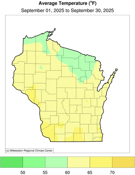
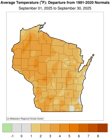
Despite the frosty start, the warm finish carried the statewide average temperature to 62.2 degrees, which is 2.7 degrees above the 1991 to 2020 normal and the thirteenth warmest September on record since 1895 (Figure 3).

A Few Drops in the Bucket
Wisconsin’s dry conditions from August bled into September. The Dane County Regional Airport in Madison reported precipitation on only five days during the month, the fewest rainy days in September since 2004!
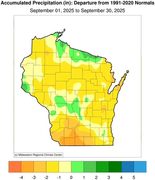
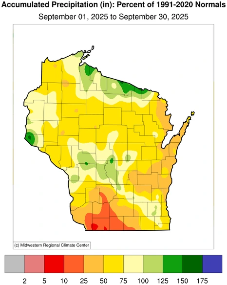
The rain that did fall didn’t amount to much in many places: the statewide average for the month was only 2.40 inches, 1.19 inches drier than average (Figure 4).
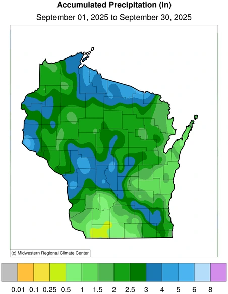
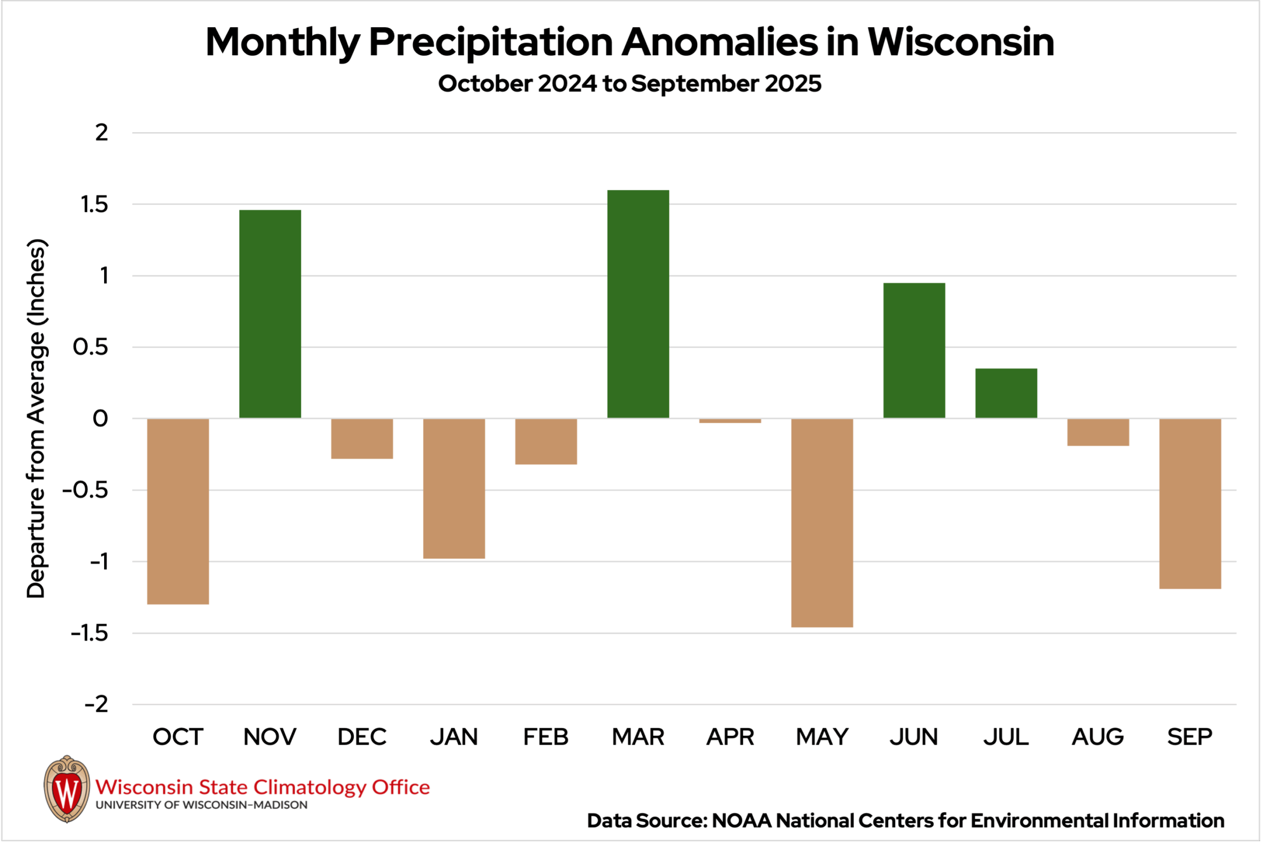
After missing out on much of the rain last month, central and northern Wisconsin received the most precipitation during September. Widespread monthly totals of two to four inches were seen in those regions.
Much of northern Wisconsin’s moisture came on September 9 and 10, with a complex of showers resulting in widespread reports of one to two inches.
Back-to-back systems on September 19 and 20 poured one to two inches of rain across the central and southern parts of the state, while northern Wisconsin was left with less than a half inch.
Morning and afternoon rounds of storms on September 22 dumped enough rain on La Crosse to tie the city’s daily rainfall record of 1.7 inches that had been previously reached in 1959. Totals across the rest of southern Wisconsin ranged from a half inch to two inches of rain for most, aside from Waukesha County, where many cities reported over two inches.
The end of September marks the end of the 2024-25 water year. The term has been used for nearly a century by hydrologists monitoring surface water supply, such as streamflow and runoff. Runoff data for water year 2025 will not be available for several months.
Severe Weather Season Hangs On
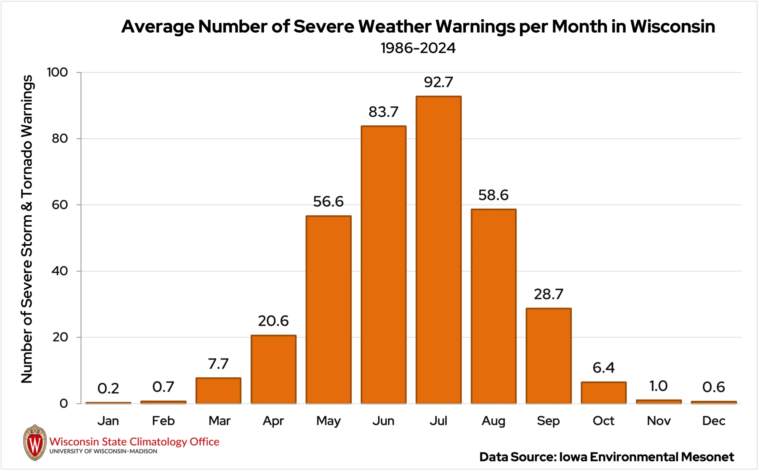
As temperatures cool and the atmosphere stabilizes during the autumnal months, thunderstorms and severe weather become less frequent in Wisconsin. Based on the issuance of warnings by the National Weather Service offices, severe weather activity typically halves in September compared to August (Figure 5). September 2025 was no different in Wisconsin.
Aside from a few storms dropping pea-sized hail through southern Wisconsin on September 13 and 20, the severe weather department was quiet across the state until September 22.
A morning round of thunderstorms rolled through the southern part of the state on September 22, taking down trees and power lines in Vernon County. Two lightning strikes in the county caused power outages in the village of Stoddard, but no injuries were reported.
Unfortunately, in Fond du Lac County, a Wisconsin Department of Natural Resources forestry worker was caught out in the storm and was struck and killed by lightning. This marked the first lightning strike death in Wisconsin since August 2021, according to the National Lightning Safety Council.
A second round of storms developed during that same afternoon, hitting southern Wisconsin once again. Strong winds took down trees in parts of Jefferson and Waukesha counties, and a storm chaser estimated lime-sized hail (two inches) hit their car while driving through the storms from Grant to Iowa County.
A short-lived tornado was confirmed in Mount Sterling in Crawford County after minor damage to corn and farm buildings was observed by emergency managers (Table 4). This marks Wisconsin’s 39th tornado this year, tying the record for sixth most in the state in a calendar year.
| September 2025 Tornadoes in Wisconsin | ||||
|---|---|---|---|---|
| Location | Date | Enhanced Fujita (EF) Rating | Estimated Maximum Winds | Damage Reported |
| Mount Sterling (Crawford Co.) | September 22 | EF0 | 75 mph | Minor damage to corn, outbuilding, and silo. |
Dry Conditions Spread
Prolonged stretches of dry and hot weather through the month allowed abnormally dry conditions (D0) to spread across the state (Figure 6). Northern Wisconsin, especially, saw an increase in abnormal dryness, as did some parts of the southern region.
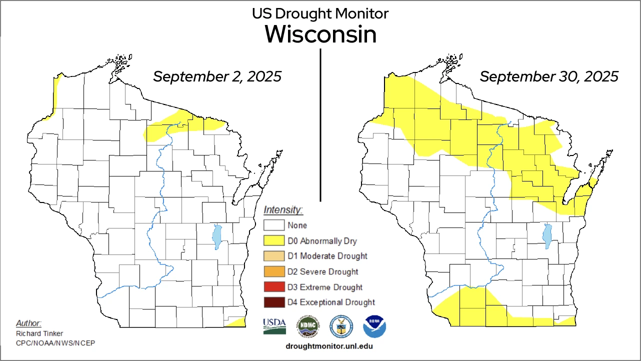
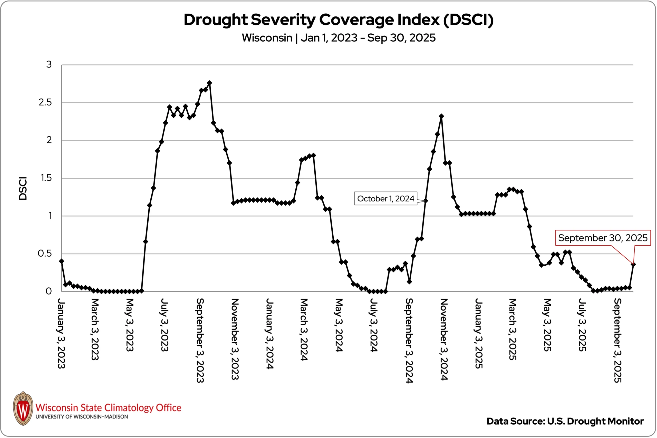
A similar pattern was seen last September: Wisconsin was plagued with stretches of dry weather following a wet summer. By the end of September 2024, conditions were more severe, with many areas of moderate drought (D1) in the state (Figure 7). By the end of October 2024, the entire state was experiencing drought for the first time since at least 2000, with some areas of severe drought (D2). Hopefully, we won’t see a full repeat of that pattern this fall!
Harvest Begins
The early-month chill had gardeners covering tender plants and raised the possibility of frost damage in some areas. For corn, the cooler temperatures may have extended grain filling and produced heavier kernels in areas without frost. However, the below-normal temperatures, combined with a few drops of rain, likely slowed natural dry down.
By the final weeks of September, the summerlike warmth was ideal for apple harvest and ripening pumpkins. Most pumpkins matured where excess rain or cold damage did not occur, though early frost-stricken fields may have seen halted growth.
The warmth also sped up the maturity of corn and soybeans. Corn silage harvest was already two-thirds complete statewide by month’s end, and farmers were planting cover crops into harvested fields, though dry soils made establishment difficult.
As farmers began to move grain to market, transportation challenges reemerged for the fourth year in a row. Extremely dry conditions along the Ohio River Basin and in the lower Midwest have led to low water levels on the Lower Mississippi River, once again restricting tow sizes and increasing barge rates. Southbound grain shipments plunged from 2.4 million short tons (one short ton equals 2,000 pounds) in August to 502 thousand short tons in September, a 79 percent drop.
Lost in the Fog
As temperatures drop during the fall, fog becomes more common as moisture condenses in the cool air. However, some northern areas of the state battled dense fog more frequently than normal in September, causing visibility to drop to a quarter-mile or less on many mornings!
The airport in Green Bay reported visibility under a quarter mile for 73 hours of the month — the second most on record for the city (Figure 8)!
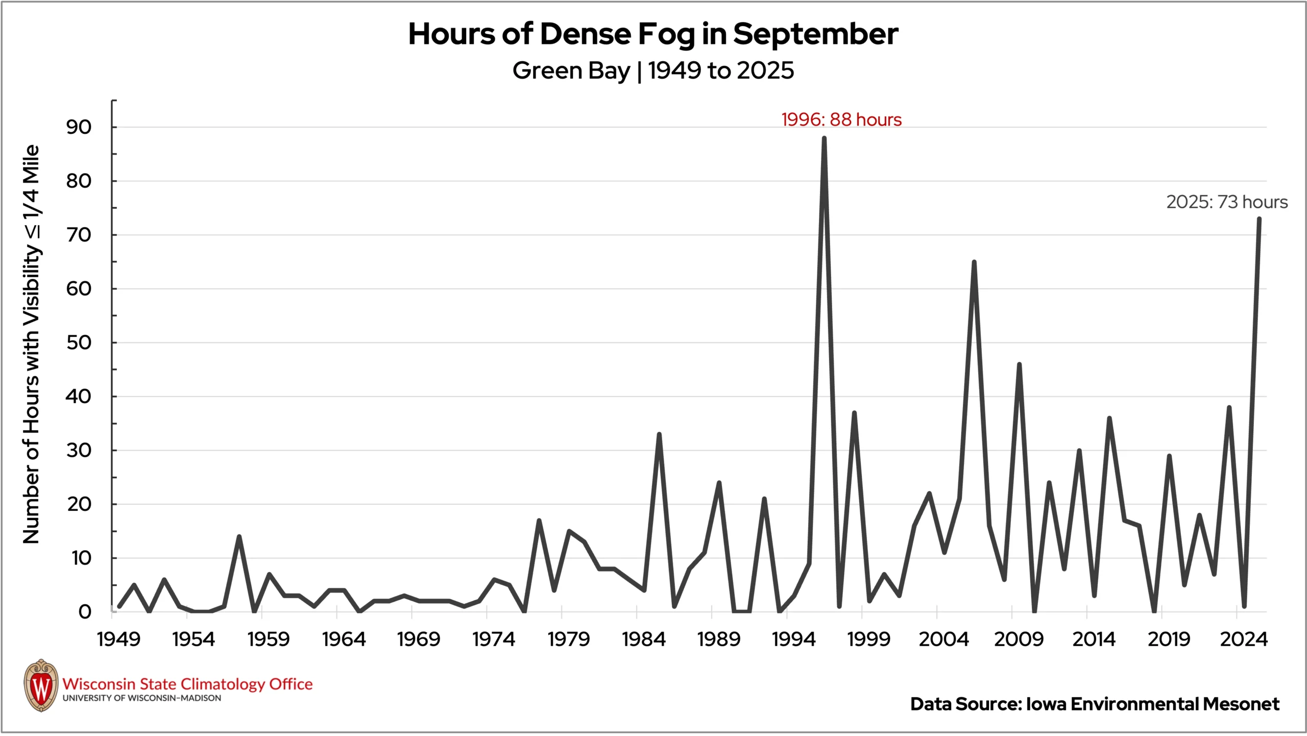
Even farther north, Ashland (Ashland County) experienced its foggiest September on record with 112 hours of dense fog! Eight dense fog advisories were issued for Ashland and Bayfield counties through the month, the most of any month for those counties since 2009.
Thanks to mild overnight temperatures, many areas farther south avoided the persistent fogginess.
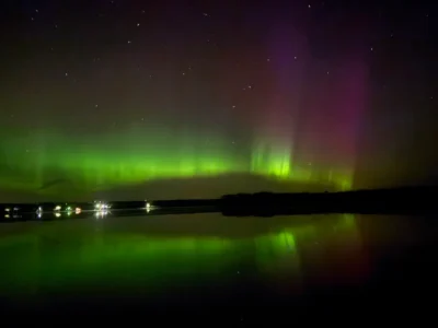
Dancing Lights in the Night
Wisconsin was treated to at least three nights of northern lights this September — on September 1, 14, and 29.
While a visit from the aurora requires many factors to align, these sightings weren’t purely by chance. The aurora is most likely to glow here between September and March, when long nights and crisp, clear skies provide the best backdrop.
Fall and spring equinoxes, around September 21 and March 21, also tend to align with a boost in geomagnetic activity — making September a prime month for skywatchers to catch the colorful display (Image 2).
Climate Corner
Arguably, the most anticipated characteristic of fall is the changing colors of the trees (unless you’re a football fan). Weather plays a huge role in the timing, longevity, and vibrancy of the state’s fall scenery — but did you know that certain colors dominate different regions? Whether you’re partial to deep burgundys or fiery oranges, learn where to find them in Wisconsin in this month’s Climate Ed-ucation blog!
Climate Stats by Division
September 2025 Temperature (degrees Fahrenheit)
Color Key
-
Dark blue: Record coolest
-
Royal blue: Bottom ⅒
-
Light blue: Bottom ⅓
-
White: Normal
-
Light orange: Top ⅓
-
Orange: Top ⅒
-
Red: Record warmest
| Division | Avg | Dept |
|---|---|---|
| Northwest | 61.0Top ⅒ | 3.1Top ⅒ |
| North Central | 59.9:Top ⅓ | 2.7:Top ⅓ |
| Northeast | 59.8:Top ⅓ | 2.1:Top ⅓ |
| West Central | 63.8:Top ⅓ | 3.2:Top ⅓ |
| Central | 63.2:Top ⅓ | 3.0:Top ⅓ |
| East Central | 62.7:Top ⅓ | 2.1:Top ⅓ |
| Southwest | 64.6:Top ⅓ | 2.8:Top ⅓ |
| South Central | 64.8:Top ⅓ | 2.7:Top ⅓ |
| Southeast | 64.0:Top ⅓ | 1.7:Top ⅓ |
| State | 62.2:Top ⅓ | 2.7:Top ⅓ |
Heating Degree Days
Color Key
-
Dark blue: Record most
-
Royal blue: Top ⅒
-
Light blue: Top ⅓
-
White: Normal
-
Light orange: Bottom ⅓
-
Orange: Bottom ⅒
-
Red: Record fewest
| September 2025 | Since July 1, 2025 | |||
|---|---|---|---|---|
| Division | Avg | Dept | Avg | Dept |
| Northwest | 148: Bottom ⅒ | -79: Bottom ⅒ | 245: Bottom ⅒ | -94: Bottom ⅒ |
| North Central | 172: Bottom ⅒ | -73: Bottom ⅒ | 298: Bottom ⅓ | -88: Bottom ⅓ |
| Northeast | 172: Bottom ⅓ | -57: Bottom ⅓ | 279: Bottom ⅓ | -74: Bottom ⅓ |
| West Central | 98: Bottom ⅒ | -68: Bottom ⅒ | 148: Bottom ⅒ | -82: Bottom ⅒ |
| Central | 105: Bottom ⅓ | -67: Bottom ⅓ | 163: Bottom ⅒ | -79: Bottom ⅒ |
| East Central | 108: Bottom ⅓ | -51: Bottom ⅓ | 160: Bottom ⅓ | -65: Bottom ⅓ |
| Southwest | 84: Bottom ⅓ | -55: Bottom ⅓ | 127: Bottom ⅓ | -67: Bottom ⅓ |
| South Central | 78: Bottom ⅓ | -52: Bottom ⅓ | 113:Bottom ⅓ | -64: Bottom ⅓ |
| Southeast | 88:Bottom ⅓ | -34: Bottom ⅓ | 126: Bottom ⅓ | -43: Bottom ⅓ |
| State | 101: Bottom ⅓ | -51: Bottom ⅓ | 153: Bottom ⅓ | -62: Bottom ⅓ |
Liquid-Equivalent Precipitation (Inches)
Color Key
-
Dark brown: Record driest
-
Light brown: Bottom ⅒
-
Beige: Bottom ⅓
-
White: Normal
-
Light green: Top ⅓
-
Green: Top ⅒
-
Dark green: Record wettest
| September 2025 | Since Nov. 1, 2024 | |||
|---|---|---|---|---|
| Division | Avg | Dept | Avg | Dept |
| Northwest | 2.59: Bottom ⅓ | -0.97: Bottom ⅓ | 27.91: Normal | -1.46: Normal |
| North Central | 3.10: Normal | -0.65: Normal | 31.33: Top ⅓ | 1.23: Top ⅓ |
| Northeast | 2.37: Bottom ⅓ | -1.21: Bottom ⅓ | 31.30: Top ⅓ | 2.39: Top ⅓ |
| West Central | 2.98: Normal | -0.75: Normal | 33.17: Top ⅓ | 1.08: Top ⅓ |
| Central | 2.46: Bottom ⅓ | -1.04: Bottom ⅓ | 32.64: Top ⅓ | 1.46: Top ⅓ |
| East Central | 1.39: Bottom ⅒ | -1.75: Bottom ⅒ | 29.12: Normal | -0.62: Normal |
| Southwest | 1.59: Bottom⅓ | -2.26: Bottom ⅓ | 34.57: Top ⅓ | -0.21: Top ⅓ |
| South Central | 1.64:Bottom ⅓ | -1.89:Bottom ⅓ | 31.45: Normal | -2.36: Normal |
| Southeast | 2.21: Bottom ⅓ | -1.12:Bottom ⅓ | 32.79 Top ⅓ | 0.37 Top ⅓ |
| State | 2.40:Bottom ⅓ | -1.19Bottom ⅓ | 31.30Top ⅓ | 0.25Top ⅓ |
Monthly, seasonal, and annual temperature and precipitation values and rankings published in this report are from NOAA’s National Centers for Environmental Information at the time of posting this climate summary. Values and rankings can change after publishing our climate summaries. To check the most recent values and rankings, visit NOAA’s National Centers for Environmental Information Climate at a Glance Tool.
This report is a product of the Wisconsin State Climatology Office. For questions and comments, please contact us by email (stclim@aos.wisc.edu) or phone (608-263-2374).