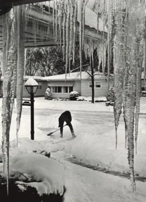
The first month of a new year can bring feelings of optimism, rejuvenation, and excitement…and often Wisconsin’s toughest winter weather! With frigid temperatures and persistent gray skies, January is the true test of Wisconsinites’ perseverance.
Temperature
The Outlook: Another Chilly Month?
NOAA’s Climate Prediction Center is forecasting a chance for cooler-than-average temperatures during January. In fact, the entire Great Lakes and northeast regions could see a cold start to the new year.
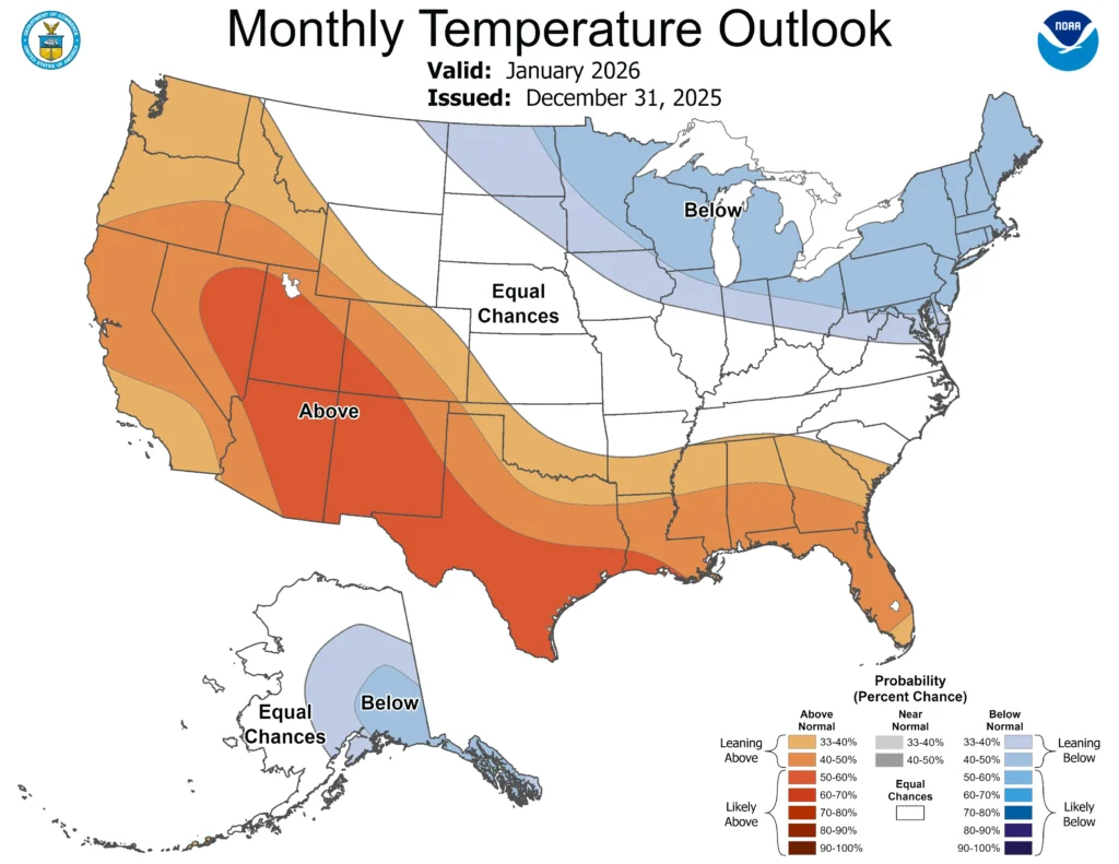
Note that the colors of the above map indicate the probability of above or below average temperatures, not the intensity of the expected warmth or cold. In this case, Wisconsin has a 40 to 50 percent chance of experiencing below-average temperatures in January.
Check out this blog for more information on deciphering climate probabilities.
The Averages:
January is Wisconsin’s coldest month, when blasts of arctic air and wind chills of 20 below are common. An analysis by the State Climate Office found that over half (56 percent) of Wisconsin’s coldest days typically occur during the first month of the year. The statewide average temperature for January is 15.3 degrees Fahrenheit.
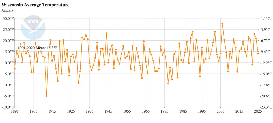
Wisconsin’s most brutal January was in 1912, when the average high was five below, and the average low was 15 below! The statewide average temperature for the month was minus 5.1 degrees — the only month on record in Wisconsin to have an average temperature below zero. The mercury stayed at or below zero degrees for numerous days, setting records at five of Wisconsin’s six first-order stations.
| Wisconsin Extremes During January 1912 | ||
|---|---|---|
| Location | Consecutive Days with High Temperature ≤0°F | Coldest Temperature |
| Milwaukee | 4 | -18°F |
| Madison | 9 | -25°F |
| La Crosse | 4 | -34°F |
| Green Bay | 10 | -27°F |
| Eau Claire | 11 | -36°F |
| Wausau | 12 | -35°F |
By contrast, Wisconsin’s mildest January was in 2006, when the average temperature was 27.7 degrees. Average highs for the month were above freezing, and many locations saw 50-degree days throughout.
Precipitation
The Outlook: To Be Determined
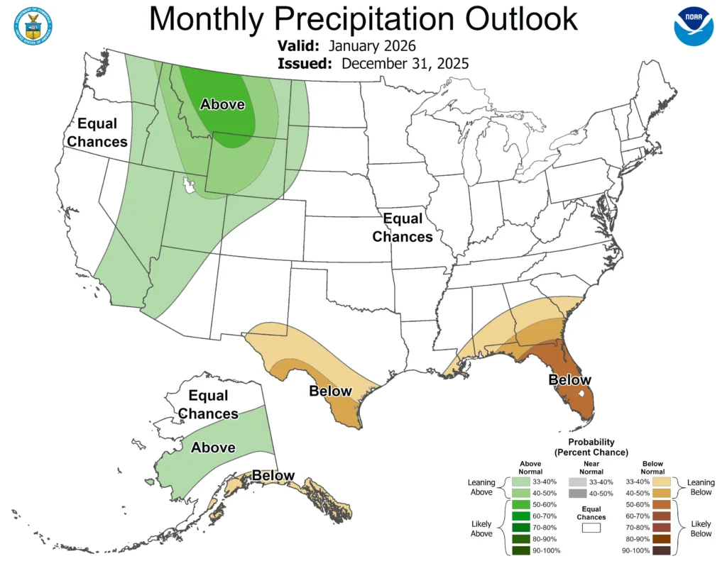
The Climate Prediction Center does not see any significant signal in the precipitation outlook for Wisconsin this month, giving the state equal chances of experiencing above, below, or near average precipitation. Snow-enthusiasts in the Rocky Mountains could be in luck, as the region could see wetter than typical conditions in January.
The Averages:
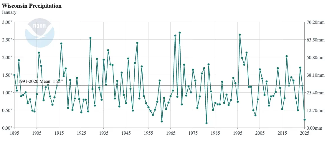
January is typically Wisconsin’s second driest month, averaging just a few hundredths of an inch more than February. However, January is often the state’s snowiest month, averaging 13.2 inches of snow statewide. Wisconsin’s far northern counties typically receive the bulk of the snow, averaging 15 to 20 inches in the first month of the year.
While this may seem contradictory, colder temperatures in January often result in snowfalls with a lower water content compared to typical December snows, which have a higher water content (and are better for snowball-making).
Wisconsin’s driest January was in 1981, when the statewide average precipitation was just 0.13 inches — over an inch drier than average.
You may remember how dry last January was, when much of the state saw less than an inch of snow. Ranking as the state’s third driest, January 2025 was the driest on record for the cities of La Crosse, Madison, and Milwaukee. That month, La Crosse measured only 0.6 inches of snow, equal to 0.03 inches of precipitation.
January of 1969 was the wettest on record for Wisconsin, with an average of 2.70 inches of precipitation across the state.
Counties bordering Lake Superior saw the heaviest snow, with portions of Iron County measuring over 60 inches — more than double the average for the month!
This is a product of the Wisconsin State Climatology Office. For questions and comments, please contact us by email (stclim@aos.wisc.edu) or phone (608-263-2374).