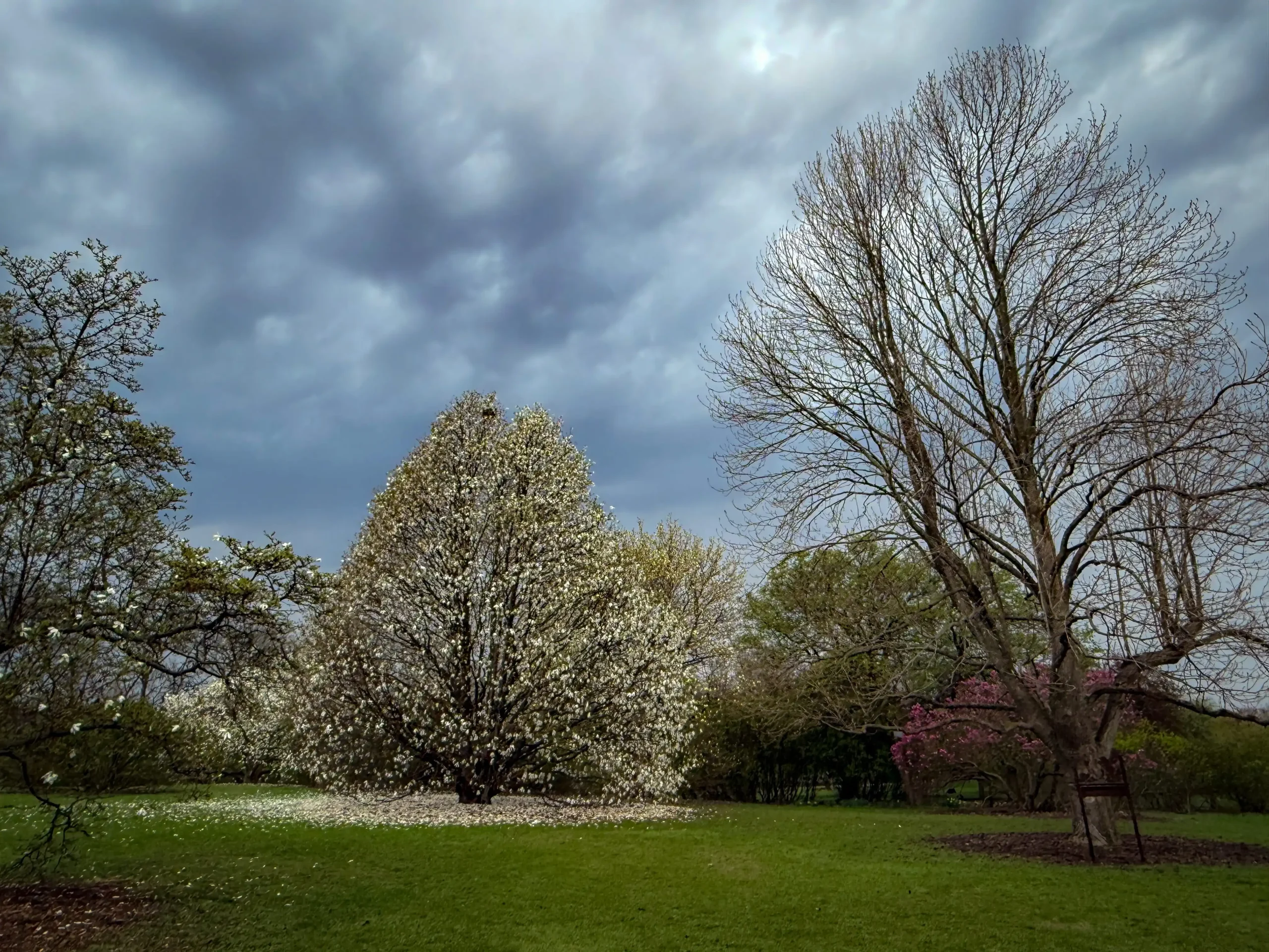
Spring is a welcome season of new beginnings, especially after a harsh Wisconsin winter! As the snow melts, songbirds return, buds emerge on trees, and the thermal layers are pushed into the back of the closet. Of course, spring in Wisconsin hardly ever means a clean break from winter weather.
When meteorologists and climatologists talk about the spring season, we’re using meteorological spring from the start of March through the end of May. The meteorological seasons slice the calendar year into four, three-month chunks based on the annual temperature cycle. This makes it easier to calculate seasonal statistics from year to year.
Temperatures
The Outlook: To Be Determined
NOAA’s Climate Prediction Center does not see any strong signals for above, below, or near average temperatures for much of Wisconsin this coming spring. However, a small sliver of northern Wisconsin is highlighted as having the potential for colder-than-average conditions. Much of the central and southern United States could experience warmer-than-average spring temperatures.
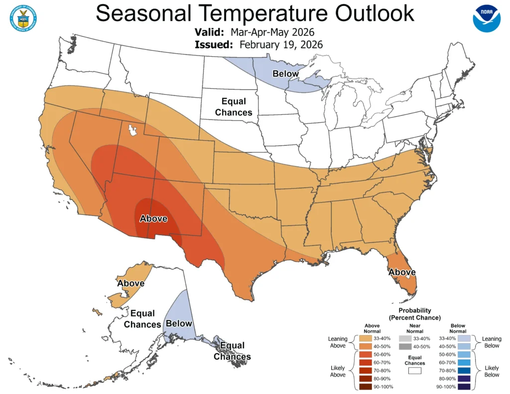
average temperatures, not the intensity of the expected warmth or cold. In this case, northern Wisconsin has a 33 to 40 percent chance of below-average temperatures across March, April, and May. Check out this blog for more information on deciphering climate probabilities.
The Averages:
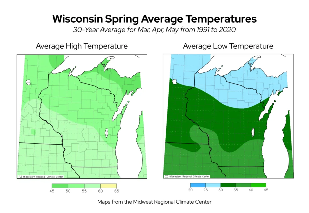
Wisconsin’s average spring temperature is 43 degrees Fahrenheit. Average high temperatures are fairly uniform across the state, ranging from 50 to 60 degrees. Low temperatures differ quite a bit more, ranging from 25 to 30 degrees in the far northern counties to a milder 35 to 40 degrees in the south.
Gardeners eagerly await the arrival of spring, particularly the final freeze of the season. The majority of the state typically experiences the final spring freeze around the first week of May. However, some lakeshore areas in southeast Wisconsin, such as Milwaukee, are rid of the freeze by the end of April.
The Midwest Regional Climate Center’s Freeze Date tool allows you to see the average for your county.
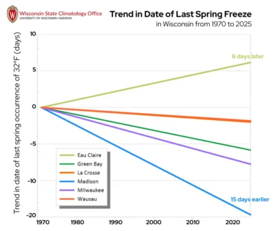
Wisconsin’s springs have been warming in recent decades, which has caused the freezing season to end earlier. Many locations in Wisconsin have seen the final spring freeze occur one to two weeks earlier than it used to.
The Extreme Seasons:
Spring of 2012 brought steamy conditions, ranking as the Badger State’s warmest spring on record.
The state experienced its warmest March on record after temperatures soared into the mid-80s in the middle of the month. Madison, Milwaukee, Green Bay, and Eau Claire all set new records for their earliest 80 degree temperature of the season.
Thanks to the early warmth, spring plants began flowering up to 6 weeks earlier than normal.
Wisconsin’s coldest spring was in 1950, when the statewide average temperature for the season was 36.7 degrees — more than six degrees colder than typical.
Winter wouldn’t let Wisconsin out of its grasp as a surge of cold air in early March brought temperatures in the northern half of the state to 15 to 20 degrees below zero. Sub-zero temperatures even stretched into early April for the far northern region of the state.
Precipitation
The Outlook: Leaning Wet
The Great Lakes region could see a wetter-than-average spring this year, according to the Climate Prediction Center. Most of Wisconsin has a 33 to 40 percent chance of above average precipitation, while the northeast region of the state has a slightly higher chance at 40 to 50 percent.
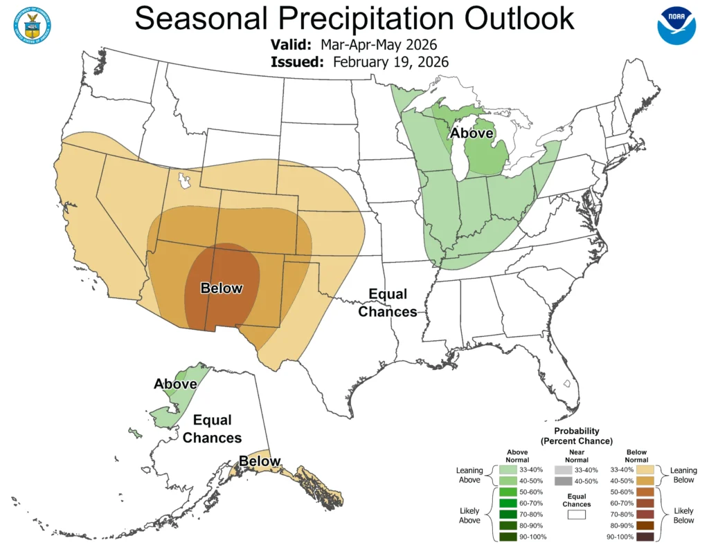
Remember that spring precipitation can come in a variety of forms in Wisconsin, from rain showers to sleet to snowstorms.
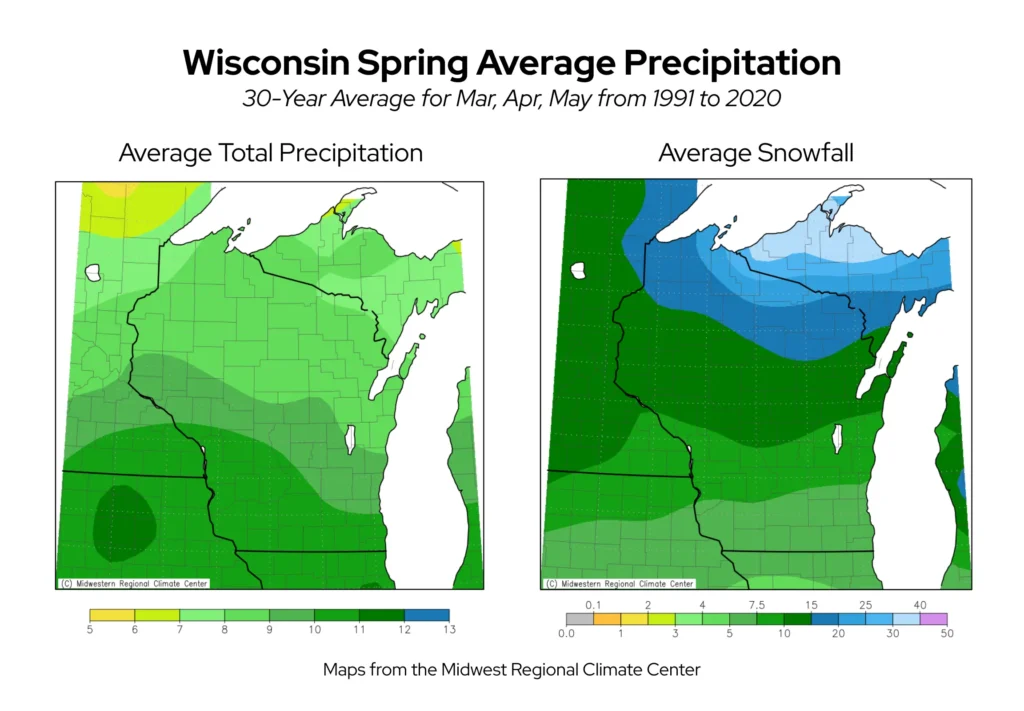
The Averages:
Wisconsin typically averages 8.95 inches of precipitation across the state in spring. Higher precipitation totals are usually seen in southern Wisconsin, with an average of 10 to 11 inches for the season, most of which comes as rainfall. Northern counties are drier overall, but can receive upwards of 20 inches of snow.
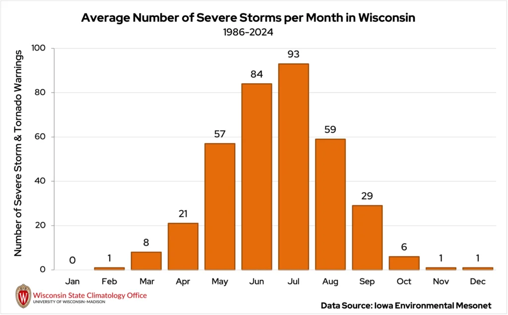
As temperatures warm through the season, thunderstorms begin to develop more frequently. The threat of severe weather, such as hail, damaging winds, and tornadoes, grows as more energy builds in the warming atmosphere. As it’s usually the warmest of the three spring months, May has historically been the most active for severe weather.
The Extreme Seasons:
There was no shortage of spring showers in Wisconsin in 1973. The statewide average precipitation total was 14.11 inches, close to double the season’s normal. That April ranked as La Crosse’s wettest on record, with over seven inches of precipitation.

For southern Wisconsin, the majority of that precipitation came with a massive April blizzard. From April 8 to 12, over a foot of snow fell from La Crosse to Milwaukee. Madison measured nearly 17 inches of snow from the storm, and West Allis (Milwaukee County) reported just shy of 23 inches!
1925 brought the driest spring conditions to Wisconsin, with statewide average precipitation only 4.07 inches. That’s less than 50 percent of the seasonal normal. Only two to five inches of snow fell across northern Wisconsin through the entire season. Across the 91 days, many locations saw fewer than 10 days with precipitation.
This is a product of the Wisconsin State Climatology Office. For questions and comments, please contact us by email (stclim@aos.wisc.edu) or phone (608-263-2374).