2025 was a rollercoaster of a year in Wisconsin. Temperatures took wild swings, historic storms occurred, and precipitation patterns seemed unpredictable. For a more detailed look at Wisconsin’s year as a whole, check out the Annual 2025 Climate Summary.
For more information on each month and season, visit our Climate Summaries page.
Snow Shortfall
Winter 2024-25 was surprisingly dry, with statewide snowfall averaging just 24.5 inches. Large deficits of 10 to 20 inches were widespread, with the far north-central region seeing at least 40 inches below normal. January was especially parched, ranking as the third-driest on record statewide and setting local precipitation records in cities including Madison, Milwaukee, and La Crosse.
Ice Storm Havoc
After it seemed that the calendar had switched to spring, a major ice storm struck northcentral and northeast Wisconsin on March 29 to 30. A coating of a quarter to a half inch of ice bent trees, snapped powerlines, and made roads impassible. At least 60,000 customers lost power, many of whom didn’t see it restored until the following day.
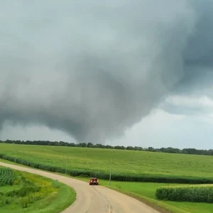
Near-Record Tornado Season
Spring and early summer were packed with severe thunderstorms, many of which spawned tornadoes. Thirty-nine tornadoes occurred across the state, the sixth most on record in Wisconsin for a single year. An outbreak on May 15 that stretched from St. Croix to Dodge County resulted in 15 tornadoes, four of which were ranked at EF2 strength.
Sizzling Start to Summer
The state’s first real taste of summer came at the end of June, when a heat dome allowed a surge of southern heat and humidity to invade the Midwest. Daytime temperatures climbed to the 90s, and heat indices exceeded 100 degrees Fahrenheit. There was little relief from the heat overnight. Temperatures remained in the 70s and 80s through the early morning hours. Nine low-temperature records were broken or tied across the state in three days, showcasing the sneaky trend in Wisconsin’s summer heat.
Smoky Summer
Plumes of wildfire smoke from Canada settled over Wisconsin over the summer, creating hazy skies and poor air quality across the state. Madison and Eau Claire recorded some of their worst air quality on record in early June. A record nine-day streak of Air Quality Advisories from July 29 to August 6 marked the longest consecutive stretch since record-keeping began in 2007. By the end of August, 22 days of poor air quality were recorded statewide — the second-most smoke-affected days in state history.
Record Rainfall

Torrential thunderstorms on August 9 to 10 unleashed historic rainfall across southeastern Wisconsin, triggering the region’s worst flash flooding since 2008. Widespread totals of five to ten inches drenched the Milwaukee metro, but one report stood far above the rest. A staggering 14.55 inches of rain fell on Milwaukee’s north side, shattering Wisconsin’s 24-hour rainfall record that had stood since 1946.
Summer in October
Instead of donning flannels and sipping apple cider, Wisconsinites were still running air conditioners as summerlike heat stretched into early October. At least 18 daily records were shattered or tied across the state, with highs nearing 90 degrees from southern to northeastern Wisconsin. Even the nights felt like summer, as unusually warm mornings set additional records.
Drought Re-emerges
After rounds of summer thunderstorms wiped drought off the map in July, Wisconsin’s fortunes reversed quickly. Persistent dry weather through fall caused drought to spread and intensify, with severe drought developing in parts of northern and southern Wisconsin by late fall. The rapid flip from saturated to parched contributed to more than 200 wildfires throughout the fall. The state headed into winter with its driest conditions in more than a decade.
Wintry End to Fall
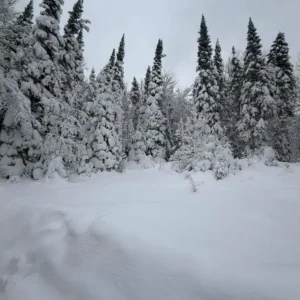
A blast of unseasonably cold air delivered a wintry end to fall. Wisconsin’s first widespread snowfall arrived weeks ahead of schedule. In early November, lake-effect snow hammered the lakeshore communities of southeastern Wisconsin. Powerful late-November storms piled up heavy accumulations across northern and southern Wisconsin. Madison and Milwaukee both set daily snowfall records on November 29. Parts of southern and central Wisconsin finished the month with more than four times their normal November snowfall.
December Deep Freeze
December picked up where fall left off, with an Arctic blast that produced the state’s coldest monthly anomaly since April 2022. Over 100 daily low temperature records were tied or broken, and northern Wisconsin stayed below freezing for two full weeks. The early-month chill only briefly gave way before winter returned by year’s end.
This is a product of the Wisconsin State Climatology Office. For questions and comments, please contact us by email (stclim@aos.wisc.edu) or phone (608-263-2374).