Wisconsin winters: you either love them or hate them. The season can be filled with skiing and sledding, fluffy snowflakes, and warm cups of hot chocolate. But it can also be filled with icy roads, back-breaking shoveling, and bitter wind chills.
You can always count on Wisconsin’s winters to bring a few big snowstorms and a couple blasts of frigid, arctic air. However, some winters bring more extremes than others.
When meteorologists and climatologists talk about the winter season, we’re using meteorological winter from the start of December through the end of February. The meteorological seasons slice the calendar year into four, three-month chunks based on the annual temperature cycle. This makes it easier to calculate seasonal statistics from year to year.
What Are El Niño and La Niña Anyway?
El Niño and La Niña are often mentioned in discussions of winter weather outlooks in the United States. These phenomena are part of a recurring climate pattern response to changing water temperatures in the Pacific Ocean off the coast of Ecuador & Peru. Abnormally cool water temperatures are indicative of La Niña, while unusually warm water temperatures indicate El Niño.
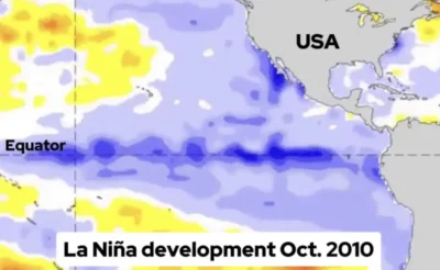
Similar to dropping a pebble in a pond, small regional changes can have larger ripple effects worldwide — fluctuations in atmospheric and oceanic circulations over the Pacific impact the position of the jet streams. As the jet streams shift, they affect temperatures and precipitation patterns across the United States.
Throughout the fall season of 2025, a small area of cool water began to develop near the equator, hinting at the onset of La Niña.
In October 2025, NOAA’s Climate Prediction Center released its forecast, predicting that weak La Niña conditions would persist from December 2025 through February 2026. This La Niña is considered weak because water temperatures are cool, but not extremely so, as in other La Niña events. Weak events typically have lesser impacts on atmospheric patterns.
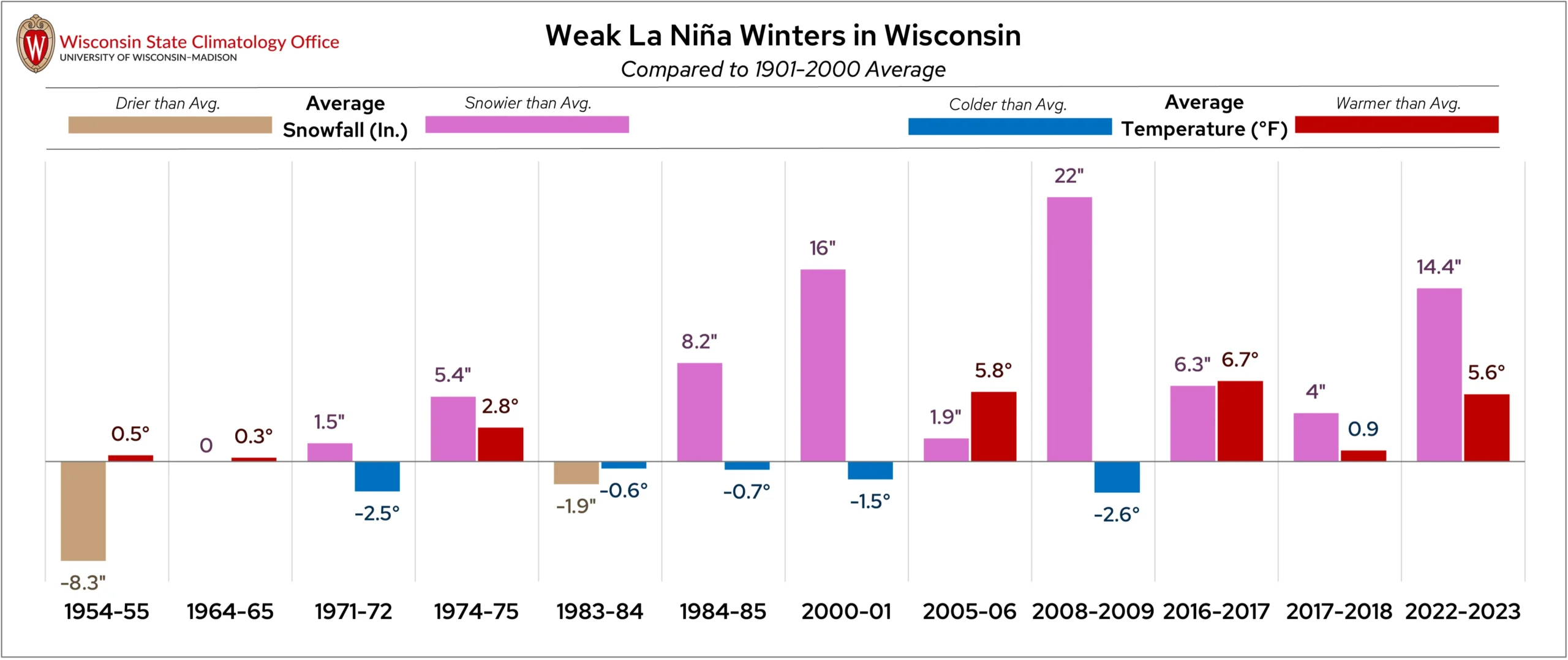
La Niña typically has little impact on Wisconsin’s winters; however, there is an interesting similarity between winters when a weak La Niña was at play.
Of the weak La Niña winter events recorded by NOAA since 1954, nine of the 12 were snowier than average in Wisconsin. During the most recent event, from December 2022 through February 2023, the state average snowfall total was over a foot higher than typical! Temperatures showed no consistent response during weak La Niña events.
We can’t give La Niña and El Niño all the credit for determining our winter seasons. Other influences, like the strength of the polar vortex, wind patterns to direct storms, and the amount of available moisture to fuel storms, can all impact what a winter season looks like in Wisconsin.
Temperatures
The Outlook: Trending Chilly
NOAA’s Climate Prediction Center is forecasting a chance of cooler-than-average temperatures in Wisconsin this winter. Many of the northern states could see a cool winter, especially North Dakota and Montana, where probabilities are higher. Much of the South and parts of the East Coast could see a milder winter season this year.
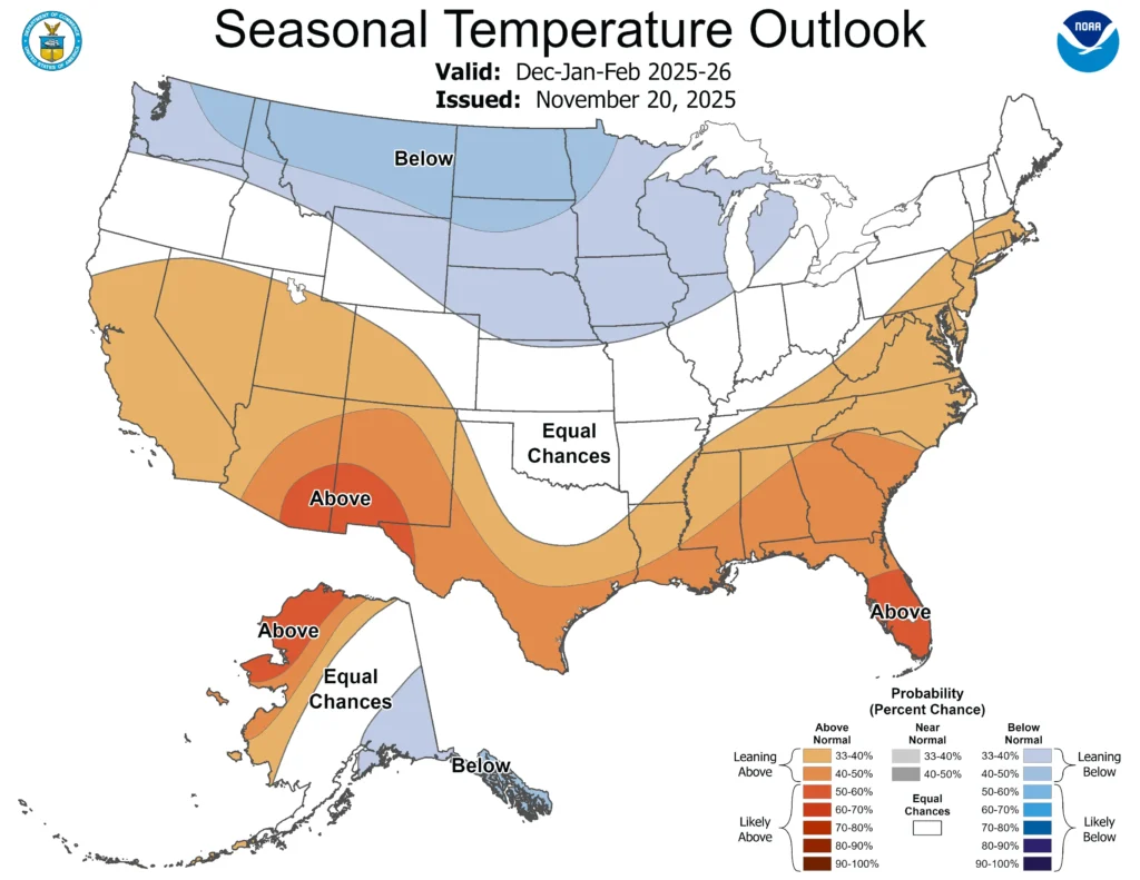
Note that the colors of the above map indicate the probability of above or below average temperatures, not the intensity of the expected warmth or cold. In this case, Wisconsin has a 33 to 40 percent chance of below-average temperatures in December, January, and February. Check out this blog for more information on deciphering climate probabilities.
The Averages:
Wisconsin’s average winter temperature is a brisk 18.5 degrees Fahrenheit. Average high temperatures range from 20 to 25 degrees in northern Wisconsin to a milder 30 to 35 degrees in the south.

Similarly, the coldest minimum temperatures are typically seen in the northern region, where average lows are typically below 10 degrees.
The most brutal of Wisconsin’s winter temperatures usually occur between January 21 and 30. Across the state, this is when days with high temperatures of 10 degrees or cooler and low temperatures below zero are most likely to occur. Fewer of these frigid days bookend the season in early December and late February.
The Extreme Seasons:
Wisconsin’s warmest winter on record was December 2023 through February 2024, when the statewide average temperature was 28.2 degrees, nearly 10 degrees warmer than average! In February 2024, Kenosha reached 77 degrees — setting a new all-time record for the warmest winter temperature in the state.
That unusual winter heat created an unstable environment that led to Wisconsin’s first February tornadoes on record. A strong El Niño pattern was at play during that winter season.
The Badger State’s coldest season on record was the brutal winter of 1903 to 1904, when the statewide average temperature was 6.8 degrees, and the average high temperature was just over 17 degrees.
The coldest Wisconsin winter in recent decades was in 2013-2014 — tied for the fourth coldest winter on record! During that winter, Madison Water Utility repaired over 200 water main breaks, and some water mains even froze due to the extreme cold. Farther north, Green Bay and Wausau both saw the highest number of below-zero temperatures of any winter season on record.
Precipitation
The Outlook: Leaning Wet
The Midwest could see a wetter-than-average winter this year, according to the Climate Prediction Center. Wisconsin’s chances are on the lower end, only 33 to 40 percent, but chances are higher to our southeast in Illinois, Indiana, Ohio, and Michigan.
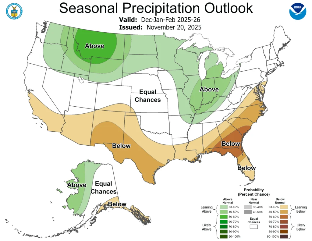
Remember that winter precipitation doesn’t necessarily mean snow, but any type of liquid precipitation. However, if the outlook materializes, cooler-than-average temperatures combined with wetter-than-average conditions could result in more snow.
The Averages:
By precipitation alone, winter is typically Wisconsin’s driest season with a statewide average of 3.9 inches of precipitation. This total accounts for snowfall by including the liquid equivalent of precipitation — meaning if two inches of snow fell into a jar and melted down to 0.2 inches of water, 0.2 inches would be reported as the amount of precipitation that fell.
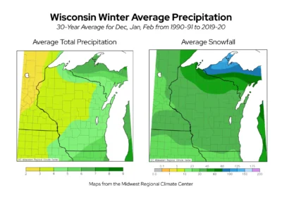
For snowfall, the majority of Wisconsin receives 30 to 40 inches each winter. Totals increase up to 80 inches in the far northern counties of the state.
The Extreme Seasons:
Wisconsin’s wettest winter season was in 2022-2023, when statewide average precipitation measured 6.25 inches. The average snowfall that season was 44.7 inches, which is about 14 inches more than normal.

However, that winter wasn’t Wisconsin’s snowiest on record — that title goes to the winter of 2018-2019 when the statewide average was over 57 inches!
The discrepancy between Wisconsin’s wettest and snowiest winter likely comes down to the water content of the snow that fell. Interestingly, a weak El Niño impacted the winter of 2018-2019, while a weak La Niña impacted 2022-2023.
The state’s driest winter on record was from 1986-1987. The statewide average precipitation during that season was just 1.32 inches, and the average snowfall across the state was 15.5 inches.
This is a product of the Wisconsin State Climatology Office. For questions and comments, please contact us by email (stclim@aos.wisc.edu) or phone (608-263-2374).