The last month of meteorological summer ended with an intense heatwave; however, temperatures averaged near normal for August and for the entire summer. Rainfall varied widely this season, with some experiencing drought and others heavy downpours, and severe weather was relatively limited.
A Temperature Parfait
Wisconsin experienced a “temperature parfait” during August, consisting of three distinct thermal periods. The month started with several days of hot weather, beginning with scores of stations reaching at least 90 degrees on the first and a 94-degree afternoon greeted visitors at the opening of the Wisconsin State Fair in West Allis. The statewide average temperature from August first to the fifth was a substantial five degrees warmer than normal.
A long stretch of very comfortable conditions immediately ensued, with temperatures running below normal by two degrees until August 23. However, the taste of early fall was displaced by an intense heat wave during the final week of August that led to a statewide average temperature of five degrees warmer than normal, matching the warm conditions that started the month.
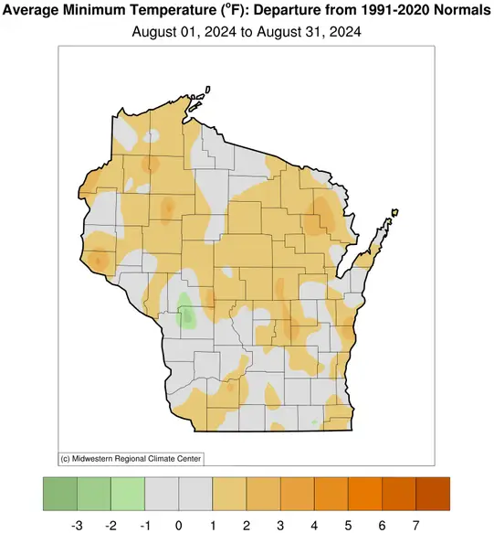
For August as a whole, these temperature swings mostly canceled each other and resulted in a Wisconsin monthly average of 67.7 degrees, only 0.5 degree(s) warmer than normal. This is illustrated by the map of daily average temperatures across the state (Figure 1), which shows that most locations deviated less than a degree from normal during August and there were no exceptional regions. A deeper dive indicates that daily minimum temperatures were somewhat more abnormally warm than were daytime maximum readings (Figure 2), especially in northern Wisconsin.


Late August Heat Wave
Averages can be deceiving, however. For the second year in a row, a late-August heat wave generated the hottest weather of the year and led to the National Weather Service issuing an excessive heat warning. A slew of daily temperature records were set throughout the state during the heatwave from August 26 to 29 (Figure 3). The highest temperature of the year (98 degrees) occurred at three locations: Beloit and Brodhead in the far south and Mondovi in the west. The heat was accompanied by stifling humidity, with widespread dewpoint temperatures in the mid-upper 70s and even a couple of stations (Boscobel and Lone Rock) touching 80 degrees.

This combination of extreme heat and moisture produced dangerously high heat indices of at least 110 degrees in a few places. Although this was a significant heat wave, it was short-lived and considerably less intense than the August 2023 event, when the air temperature alone exceeded the century mark in many places and included a statewide maximum for the year of 105 degrees.
Precipitation
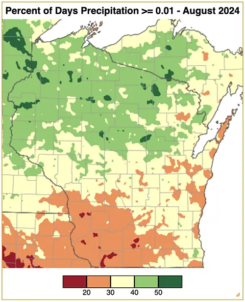
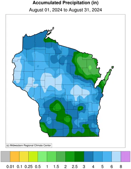
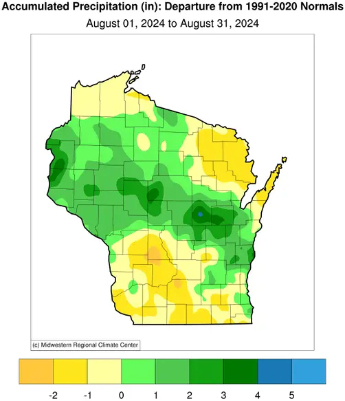
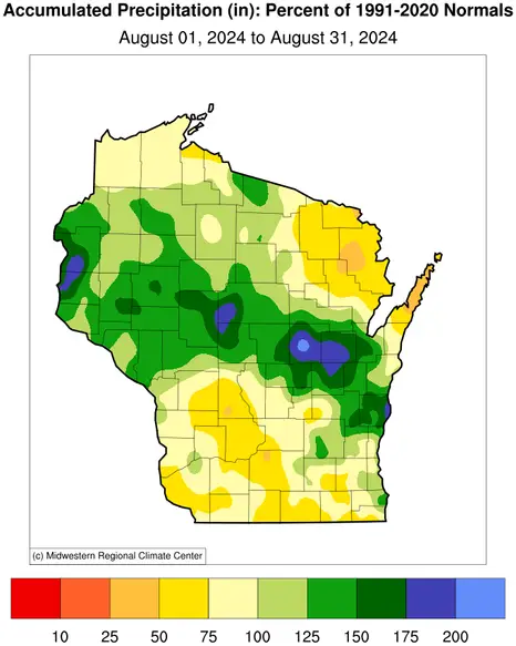
Wisconsin saw a statewide average of 4.28 inches of precipitation this August, which was 0.38 inches above the 1991 to 2020 normal of 3.90 inches. Despite August’s near-normal statewide amounts, rain fell infrequently, with measurable rainfall (at least 0.01 inches) occurring on fewer than half the days of August across Wisconsin (Figure 4). Southwestern Wisconsin was particularly parched as it saw just six to nine days of rainfall by the end of August, resulting in precipitation amounts of only 50 to 75 percent of normal for many counties (Figure 5).
In contrast, central and northwestern Wisconsin compensated for the days of minimal precipitation with widespread high rainfall intensity events of four to eight inches, resulting in accumulation well over 100 percent of normal. A few counties even neared 200 percent of normal.
Severe Weather
August, like the rest of meteorological summer, was relatively quiet in terms of severe weather. A few rounds of thunderstorms the first week of August brought torrential downpours and even reports of funnel clouds. However, the funnel clouds were short-lived and dissipated before reaching the ground. Another round of severe storms struck Wisconsin in late August, coinciding with the extreme heat. By the end of the month, the hot and humid weather broke following a cold front, but along with the cold front came three tornadoes: two EF0s and one EF1.
The tornado that was rated EF1 traveled 6.6 miles near Beldenville (Pierce County). One of the EF0 tornadoes crossed the St. Croix River and entered Pierce County and another traveled one mile along I-94 near Wilson (St. Croix County). These three tornadoes bring this year’s count up to 45, making it the third highest total since records began in 1950 (Figure 6).

| Date | County | Location | EF rating | Length | Width | Deaths/injuries |
|---|---|---|---|---|---|---|
| Feb. 8 | Green | Albany | 1 | 8.35mi | 50yd | 0/0 |
| Feb. 8 | Rock, Dane, Jefferson | Evansville | 2 | 26.2mi | 750yd | 0/1 |
| May 7 | Walworth | Fontana-On-Geneva | 0 | 5.23mi | 50yd | 0/0 |
| May 7 | Walworth | Darien | 1 | 0.98mi | 50yd | 0/0 |
| May 21 | Buffalo | Cochrane | 1 | 3.93mi | 75yd | 0/0 |
| May 21 | Buffalo | Fountain City | 1 | 2.95mi | 50yd | 0/0 |
| May 21 | Buffalo | Buffalo City | 1 | 2.78mi | 45yd | 0/0 |
| May 21 | Trempealeau | Arcadia | 1 | 0.86mi | 75yd | 0/0 |
| May 21 | Jackson | Alma Center | 1 | 3.14mi | 75yd | 0/0 |
| May 21 | Eau Claire | Augusta | 1 | 9.7mi | 90yd | 0/0 |
| May 21 | Clark | Humbird | 1 | 9.45mi | 300yd | 0/0 |
| May 21 | Clark | Loyal | 0 | 12.3mi | 100yd | 0/0 |
| May 21 | Clark | Greenwood | 1 | 4.24mi | 150yd | 0/0 |
| May 21 | Clark | Loyal2 | 0 | 6.22mi | 75yd | 0/0 |
| May 21 | Clark, Marathon | Unity | 1 | 3.53mi | 65yd | 0/0 |
| May 21 | Marathon | Fenwood | 1 | 2.11mi | 60yd | 0/0 |
| May 21 | Dane | Springdale | 1 | 4.74mi | 75yd | 0/0 |
| May 21 | Marathon | Edgar | 1 | 2.13mi | 80yd | 0/0 |
| May 21 | Marquette | Neshkoro | 1 | 5.27mi | 60yd | 0/0 |
| May 21 | Outagamie | Kaukauna | 1 | 2.68mi | 80yd | 0/0 |
| May 21 | Door | Washington Island | 1 | 2.28mi | 90yd | 0/0 |
| May 26 | Rock | Milton | 0 | 12.2mi | 50yd | 0/0 |
| May 26 | Rock, Jefferson | Lima Center | 0 | 15mi | 50yd | 0/0 |
| May 26 | Jefferson | Lake Koshkonong | 0 | 5.57mi | 30yd | 0/0 |
| June 17 | Clark | Greenwood | 0 | 0.42mi | 25yd | 0/0 |
| June 17 | Clark, Taylor | Withee | 1 | 0.91mi | 45yd | 0/0 |
| June 17 | Clark, Marathon | Colby | 0 | 0.83mi | 46yd | 0/0 |
| June 18 | Polk | Dresser | 1 | 4.99mi | 100yd | 0/0 |
| June 22 | Grant | Tennyson | 0 | 0.16mi | 40yd | 0/0 |
| June 22 | Lafayette | Belmont | 0 | 5.6mi | 75yd | 0/0 |
| June 22 | Lafayette, Green | Argyle | 2 | 6.94mi | 500yd | 0/0 |
| June 22 | Dane, Jefferson | Marshall | 1 | 4.58mi | 300yd | 0/0 |
| June 22 | Jefferson | Watertown | 1 | 2.07mi | 150yd | 0/0 |
| June 22 | Rock | Janesville | 2 | 6.21mi | 700yd | 0/0 |
| June 22 | Walworth | Williams Bay | 1 | 6.07mi | 150yd | 0/0 |
| June 22 | Walworth | Fontana | 1 | 5.31mi | 100yd | 0/0 |
| June 22 | Kenosha | Powers Lake | 0 | 1.42mi | 40yd | 0/0 |
| June 24 | Menominee, Oconto | Keshena | 1 | 8.96mi | 83yd | 0/0 |
| July 5 | Taylor | Medford | 0 | 1mi | 40yd | 0/0 |
| July 15 | Grant | Kieler | 1 | 0.29mi | 30yd | 0/0 |
| July 15 | Rock | Evansville | 0 | 1.23mi | 50yd | 0/0 |
| Aug. 29 | Pierce | Prescott | 0 | 0.78mi | 50yd | 0/0 |
| Aug. 29 | Pierce | Beldenville | 1 | 6.63mi | 50yd | 0/0 |
| Aug. 29 | St. Croix | Wilson | 0 | 1.71mi | 50yd | 0/0 |
Although this year has appeared active in terms of the number of tornadoes, the 21 confirmed tornadoes for summer 2024 tied 1967 for fifteenth place, well behind the 58 tornadoes that slammed the state in the summer of 2005. Of the 21 tornadoes this summer, half were weak EF0s, underscoring the unexceptional severe weather this summer.
Summer Temperatures
Much like August itself, this year’s meteorological summer (June to August) featured temperatures very close to normal throughout Wisconsin. The statewide summer average was 67.3 degrees, a mere 0.1 degree above the 1991-2020 average, in sharp contrast to the fourth hottest summer on record experienced by the nation as a whole. Only in a few scattered places did daily average temperatures stray more than a degree from normal (Figure 7), although slightly larger (positive) anomalies were more common for daily minimum temperatures (Figure 8). These fairly typical average temperatures aligned with the tolerable amount of extreme heat Wisconsin experienced this summer.


Hot weather in 2024 has been brief and–except for the late-August heat wave–not especially intense, a far cry from the near record-breaking heat across much of the U.S. this summer. For example, in a typical year there are 10 days of at least 90 degrees at Wisconsin’s first-order weather stations (Eau Claire, Green Bay, La Crosse, Madison, Milwaukee, and Wausau), a frequency that’s been remarkably consistent for many decades despite the warming climate (Figure 9). By the end of summer this year, only six such hot days have occurred as our window for extreme heat rapidly closes with the arrival of September.

It also appears that Wisconsin will not record a 100-degree temperature in 2024. The absence of triple-digit heat is something that has become surprisingly common in recent years, even though Wisconsin’s annual maximum temperature used to regularly surpass 100 degrees, based on data back to the 1880s (Figure 10).

Summer Rainfall Surplus
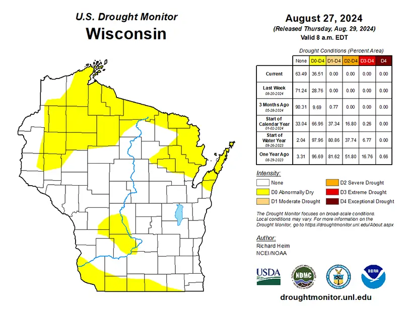
Much of Wisconsin did not have it easy this summer due to an abundance of precipitation (Figure 11). Intense downpours resulted in rainfall rates of one to two inches per hour and extreme one- and two-day precipitation events the weekend of June 21 across many counties from Sauk to Sheboygan. Heavy rains also caused a new June water level record along the Mississippi River at La Crosse and broke Madison’s one-hour accumulation record on July 14. Impacts were substantial, including the dam that failed in Waupaca County on July 5, as described in the July Climate Summary. The surplus of precipitation even pushed northern and southwestern Wisconsin out of their long-lasting drought in mid June.
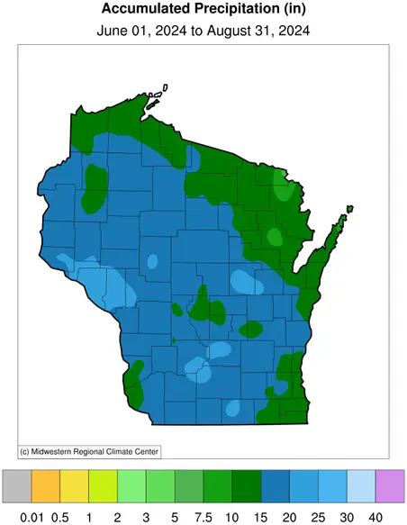

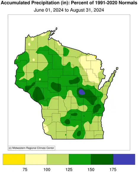
However, abnormal dryness reappeared in northern and southwestern Wisconsin by the end of July and end of August, respectively, as a result of below-normal precipitation (Figure 12). Despite the highly varying precipitation pattern (both spatially and temporally), meteorological summer ended with a statewide average of 15.73 inches, a noteworthy 3.09 inches above normal and the sixth wettest summer on record. View the latest Wisconsin drought conditions and precipitation maps

Challenging Conditions for Agriculture
The abundance of rainfall the first half of the summer made for difficult working and growing conditions. In August, nearly six days per week were suitable for fieldwork according to the National Agricultural Statistics Service. Despite the early summer challenges, Wisconsin’s corn and soybeans continued to progress, with a majority of the crops remaining in good to excellent condition and hovering right around the five-year average pace throughout the summer.
Apple quantity and quality were a mixed bag for Wisconsin’s approximately 300 orchards. Oneida Orchard is not opening this year for you-pick apples due to low yield from the false spring when many plants developed prematurely due to the record-warm winter and subsequently froze during a cold snap. However, other orchards are yielding a beautiful crop and have been open for picking as early as mid-July thanks to the warm winter pushing the apple buds to grow a lot sooner than normal.
Unfortunately, cherry growers in Door County had a rough season, as noted by Rebecca Wiepz, the superintendent of the UW–Madison’s Peninsular Agricultural Research Station in Door County. In addition to the pests and disease caused by the mild winter and warm, wet spring, the repetitive rains during June and early July made it nearly impossible to protect crops from pests and the excess moisture promoted bacterial and fungal growth. Many growers were unable to harvest fields that they found to be infested. Amazingly, of the almost 15 million pounds of cherries harvested, only 500,000 pounds were rejected, which is impressive given the conditions.
Outlook
Consistent with the outlooks featured in our recent climate summaries, while the odds are again leaning toward a warm upcoming season (September through November) throughout most of the country, there is no indication whether our state or the Upper Midwest will experience an unusually wet or dry autumn (Figure 13). The National Weather Service’s outlook issued last month calls for a 40 to 50 percent chance that Wisconsin’s fall season will be warmer than normal, with a somewhat stronger likelihood in the eastern portion. Since the late 1990s, nearly three out of four autumns in the state have been warmer than the long-term average (1895-present).
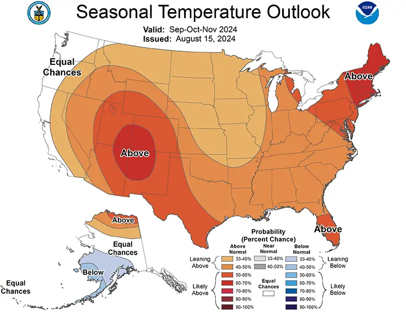
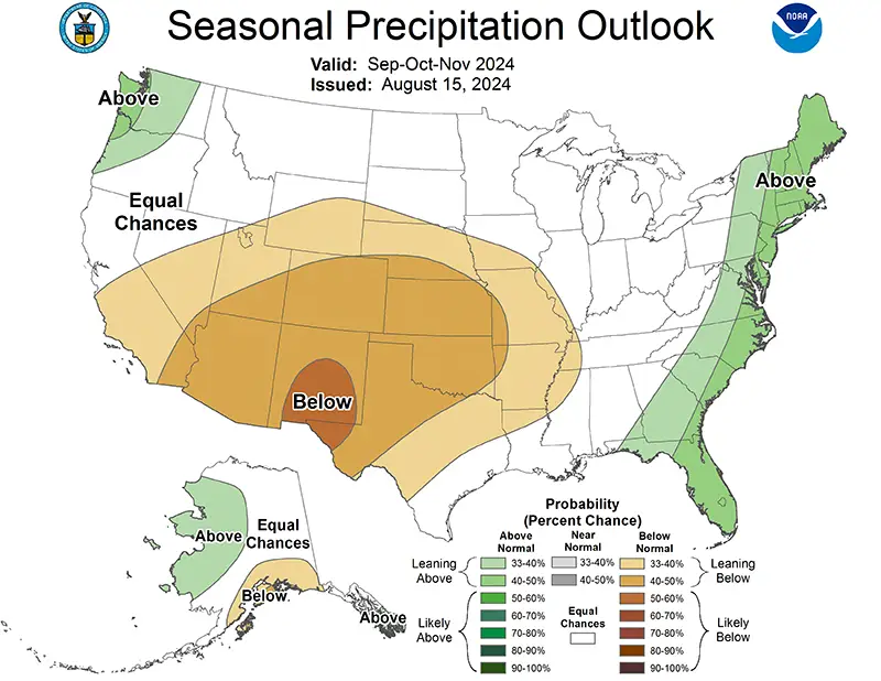
There is fairly high confidence (71 percent) that the cooler phase of theEl Niño Southern Oscillation (La Niña) will emerge during the upcoming fall season, according to the Climate Prediction Center’s mid-September forecast, although La Niña has been slower than expected to develop this year.
Climate Corner
The “dog days of summer” is a popular term to describe the hot and sultry weather often occurring in the heart of summer. According to folklore, dogs would tend to become mad (rabies) during that time of the year. However, the term goes back to ancient Egyptian astrology, as the “Dog Star,” or Sirius, would rise over the eastern horizon each day just before sunrise during July and early August. The Greeks noted that when Sirius was above the horizon during the daylight hours, heat, drought and sudden thunderstorms would often occur.
With Sirius being in conjunction with the Sun during July, the ancients reasoned that the extra light given off by Sirius during daylight would enhance the Sun’s heating. Hence, the “dog days of summer” were defined as being the 40 days running from July 3 through August 11, centered upon the alignment of Sirius with the Sun. When Sirius returned as a night star, the highly anticipated annual flooding of the Nile River would soon occur with the monsoon rains.
In Wisconsin, the hottest time of year occurs during the dog days in mid-July, based on statewide daily temperature data since 1893. The highest average daily maximum statewide temperature is approximately 82 degrees, occurring around July 19. Wisconsinites have experienced two significant heat waves in 2024, but they occurred during the third week of June and the last week of August. Thus, this year’s most memorable hot weather occurred before and after the true “dog days of summer.”
Steve Vavrus is the Wisconsin state climatologist. Bridgette Mason and Ed Hopkins are the assistant state climatologists.