Wisconsin is prone to large seasonal contrasts, not only in terms of air temperature but also in precipitation. Summers can feature frequent thunderstorms that produce locally heavy rainfall, and heavy dumpings of snow are common in winter.
Importance of Wisconsin’s Seasonal Patterns
During the six-month growing season, healthy amounts of precipitation help support Wisconsin’s $116 billion agriculture and food processing sectors.
Winter snow is vital in supporting the state’s winter recreation and tourism industries. The American Birkebeiner ski race alone is estimated to inject $4 million into northwest Wisconsin’s economy.
The warm season rain also helps the outdoor recreation and tourism industries (estimated at $25 billion) by providing abundant water for the state’s lakes and rivers.
Precipitation Phenomena
Thunderstorms
Thunderstorms are typically a summertime phenomenon in Wisconsin, with June and July usually having the most thunderstorm days. Southwestern counties of the state experience approximately 40 days during the year when thunder is heard, while northeastern counties usually have slightly fewer than 30 such days per year.
Summertime rainfall from thunderstorms can be considerable, especially when they move slowly across a region.
Snowfall
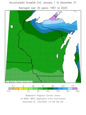
If temperatures are cold enough, precipitation can fall as snow in the Badger State from October to May. Statewide average snowfall is slightly more than 56 inches for the snow season. The snowiest season was in 2022-23 when the statewide average snowfall was nearly 82 inches!
Southern counties of Wisconsin average near 30 inches of snowfall, while totals of more than 150 inches are common along the counties immediately south of Lake Superior.
Although some people may disagree, snow is a good thing for Wisconsin. Compared to summer precipitation that flows directly into the soil, the water from winter snow often remains on the ground as snow cover. Snow cover protects the roots of trees and overwintering plants from cold winter temperatures, and spring snowmelt provides much-needed soil moisture.
Geographic Variations
Although Wisconsin does not have rugged terrain that would cause extreme variations in precipitation as seen across the western mountain states, geography does play a role in the variations seen in the Badger State.
Southern Wisconsin receives more summer rainfall because warm and humid air from the Gulf of Mexico flows northward into the Upper Mississippi Valley, fueling thunderstorms. Even in winter, snowstorms tracking close to the state can pull milder Gulf air into southern Wisconsin.
In the northern and eastern parts of the state, the stabilizing influence of Lakes Michigan and Superior tends to reduce summertime rain showers and thunderstorms.
However, the elevated terrain of the Gogebic Range, which runs through Ashland and Iron counties, contributes to lake-effect snow in the region. The elevation change enhances the snow that falls when cold winds from the north pass over the relatively warm waters of Lake Superior.
Seasonal Variations
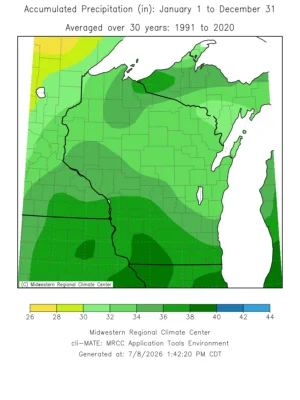
Annual liquid-equivalent precipitation (rain plus melted snow) totals vary across the state. Approximately 28 inches is typical in the eastern lakeshore counties of Lake Michigan and sections of northern Wisconsin, while western regions of the state average nearly 34 inches.
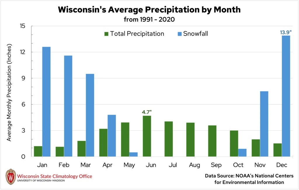
Nearly 70 percent of the state’s liquid-equivalent precipitation falls during the six-month growing season, April through September. The remaining 30 percent comes during October to February, often as snowfall. June is the month with the highest average rainfall.
Wisconsinites can usually expect precipitation every three days. Accumulations of an inch or more can typically be expected on five to eight days of the year.
Between late October and early May, measurable snow falls in the state on nearly 70 days on average. As many as 73 snow days can be found in the north central region of the state, while south central Wisconsin reports only 40 snow days per year.
Reasons for Seasonal Variability
Wisconsin’s precipitation is highest during the summer months due to the warm temperatures of the season. Air at 70 degrees Fahrenheit can hold nearly seven times as much water vapor as air on a cool, 20-degree winter night. With more water vapor in the atmosphere, a weather system can absorb that extra moisture and may produce more precipitation.
Vegetation can also contribute to slight increases in summer precipitation. During the summer, corn and soybean plants use soil moisture for photosynthesis, releasing water into the atmosphere in a process called evapotranspiration (often called “corn sweat”). However, the overall impact on precipitation is minimal, adding a little more than 10 percent of the normal summertime rainfall.
Long-Term Variations in Precipitation
Since 1950, the annual statewide precipitation has increased by over 12 percent.
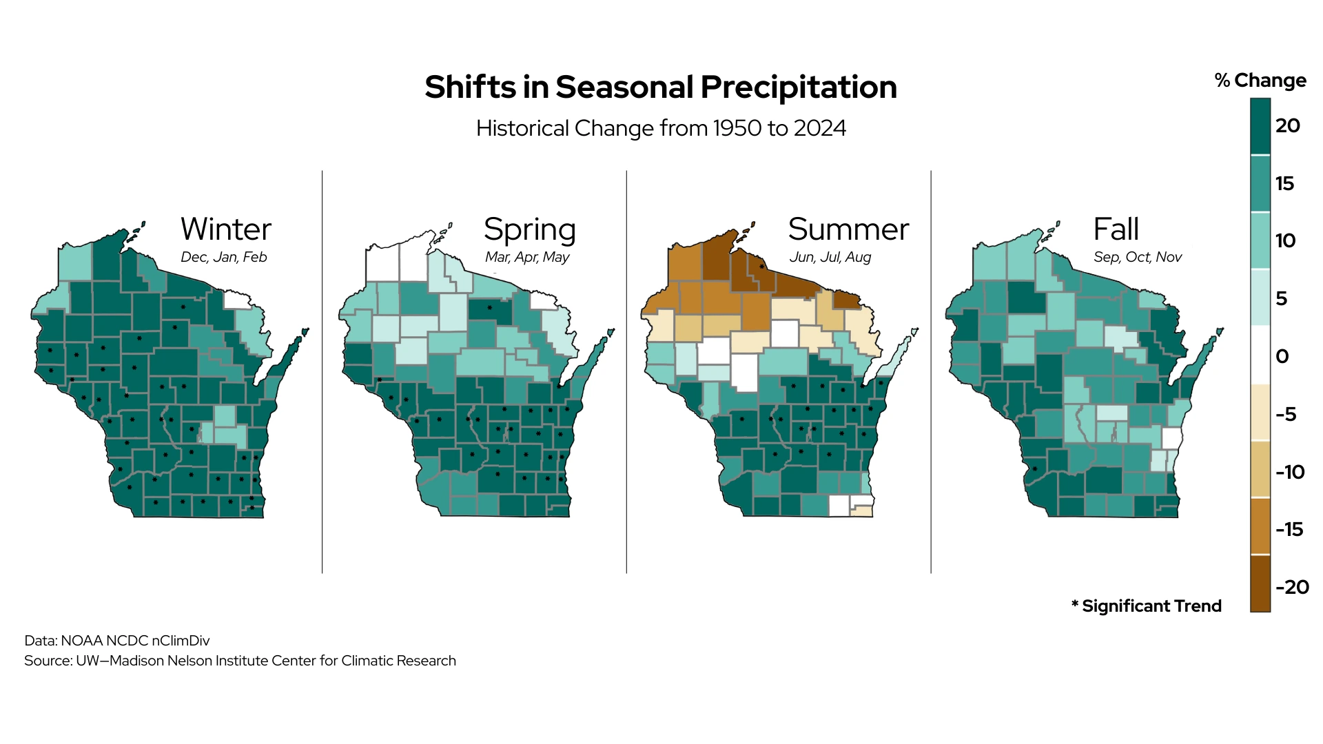
Seasonally, most areas of the state have experienced varying precipitation changes. Winter has shown the largest increase across most counties, where a 20 percent increase in precipitation has been observed over the last 75 years. Spring has shown similar increases across southern and central counties, while northern counties reported smaller percentage increases. A more scattered pattern in the increases can be found in autumn.
However, summer has shown contrasting signals across Wisconsin. Summers have become drier by as much as 20 percent in the state’s far northern counties, while many counties in central and eastern regions have experienced a 20 percent increase in summer rain.
In addition to increased precipitation, extreme rainfall events have also increased over the last several decades. These events are responsible for flooding that causes loss of homes, businesses, and crops.
Warming temperatures across Wisconsin over the last 75 winters have impacted the type of precipitation that falls. Much of the state has seen an additional three days per winter when precipitation falls as rain rather than snow.
Future Changes in Precipitation
Future projections indicate that precipitation in the Badger State could increase by another three percent by mid-century.
Winters are expected to have the largest increase at 11 percent, followed by spring with an eight percent increase. Summers could become drier by as much as five percent by 2041 to 2060.
However, days with at least two inches of precipitation could become more common, especially in western regions of the state.
These changes will affect Wisconsin’s ecosystems and could have mixed impacts on the state’s economy. Abundant water could benefit agriculture and boost recreation on Wisconsin’s lakes and rivers.
Conversely, wetter winters and springs could result in costly losses in delayed crop planting and harvesting, and cause flooding, soil erosion, and infrastructure damage. The anticipated drier summers could reduce crop yields and lead to unhealthy water quality in lakes.