For many, August is the beginning of the end of summer. Final vacations and summer outings are crammed in, student athletes start their pre-season practices, and soon it’s back-to-school time. Wisconsin’s weather usually follows suit: temperatures fall slightly, and thunderstorms become less frequent during the final month of summer.
Temperatures
The Outlook: To Be Determined
Based on forecasts from NOAA’s Climate Prediction Center, most of Wisconsin has equal chances of above-, below-, and near-normal temperatures in August. Only the far southern counties of the state are highlighted with a chance to lean warmer than average.
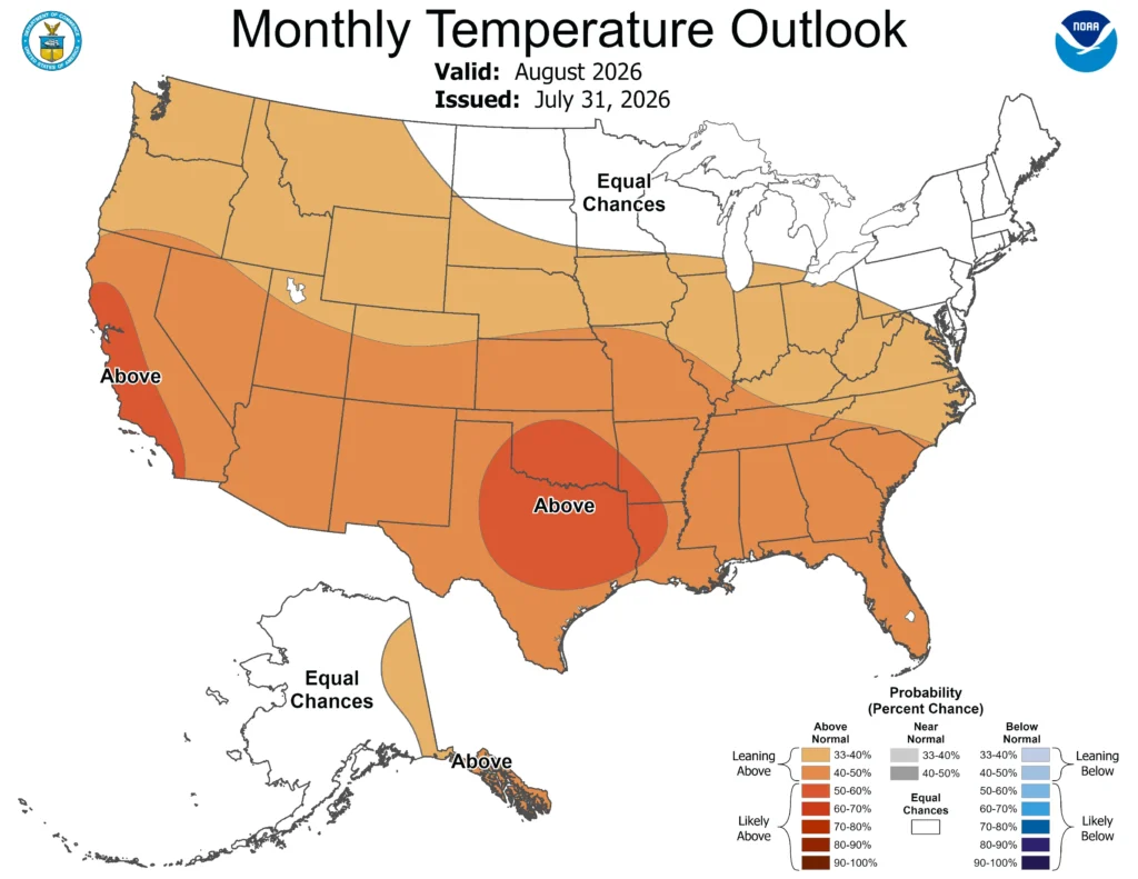
Note that the colors of the above map indicate the probability of above- or below-average temperatures, not the intensity of the expected warmth or cold. In this case, southern Wisconsin has a 33 to 40 percent chance of experiencing above-average temperatures. Check out this blog for more information on deciphering climate probabilities.
The Averages
Wisconsin’s average high temperature in August is 78.2 degrees, slightly cooler than the average for July. August typically marks the slow descent into cooler fall weather, but sometimes summer is hesitant to give up its reign. Locations across the state still experience one to four days of 90-degree heat on average during the final month of summer.
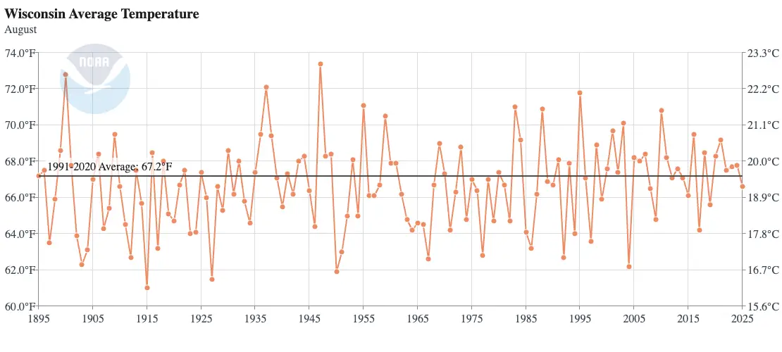
The hottest August on record was in 1947, when the average high was a toasty 85.6 degrees. During an early-month heatwave, many northern locations topped 90 degrees, with a few reaching the triple digits. The community of Danbury in Burnett County reported a high temperature of 107 degrees on August 5, 1947.
The coolest August occurred in 1915, with a statewide average temperature of just 61 degrees. Late in the month that year, many cities in the Northwoods reported overnight temperatures below freezing — some locations even reached the mid-20s! Wausau reached 32 degrees on August 30 of that year, marking the earliest the city had ever dipped below freezing.
Precipitation
The Outlook: To Be Determined
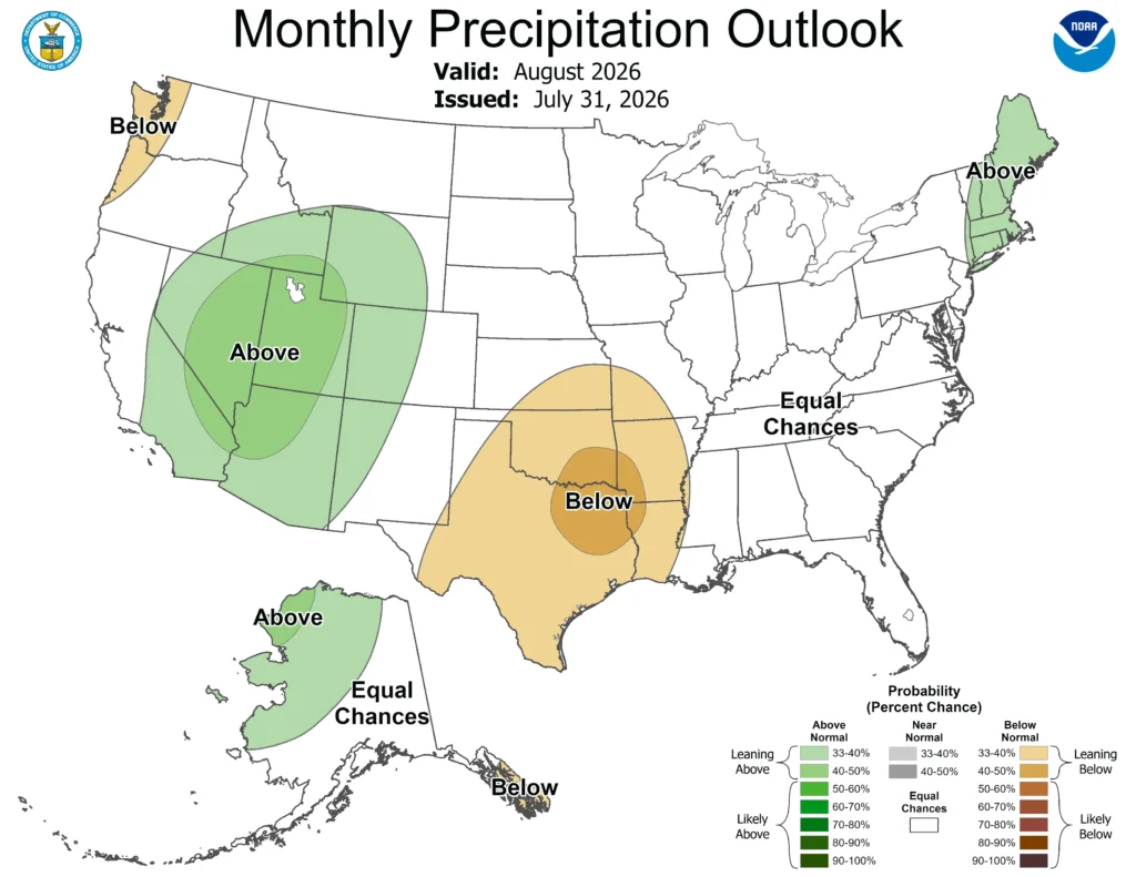
The Climate Prediction Center also sees no strong precipitation signal for Wisconsin in August, giving equal chances of above-, below-, and near-normal precipitation.
To our south, there’s a chance for drought to develop rapidly in parts of Texas and Oklahoma as dry conditions are combined with likely warmer-than-average temperatures.
The Averages
The severe weather season begins to dwindle during August, and average rainfall amounts also continue to decline. Wisconsin averages 3.9 inches of rain during the month, almost an inch less than June’s average (Wisconsin’s wettest month).
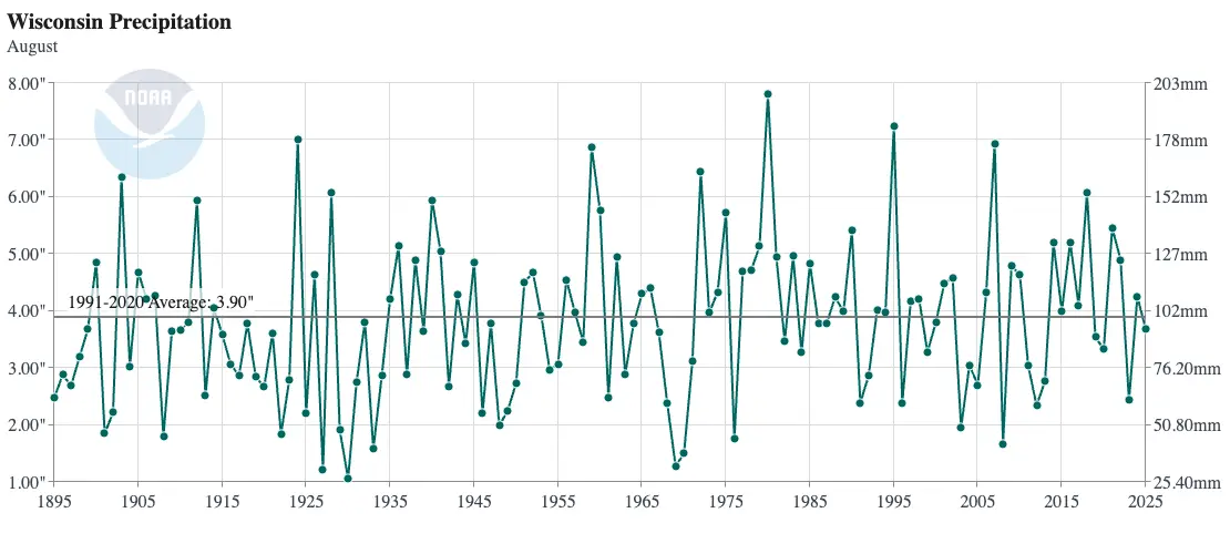
The driest August on record in Wisconsin was in 1930, during the beginning of the Dust Bowl, when the statewide average was barely over an inch — 1.06 inches to be exact! The northwestern region of the state was the driest, with areas near Ashland reporting a tenth of an inch of rain for the entire month. Lake Mills in Jefferson County reported the highest amount of rain in August that year, reaching just over three inches.
August of 1980 was the wettest in Wisconsin’s records, with an average of 7.81 inches in the state. The firehose was aimed at central Wisconsin that month, where many locations reported over 10 inches of rain. Portage in Columbia County measured just over 16 inches of rain that month.
This year will mark the first anniversary of the historic floods that occurred in southeast Wisconsin on August 9 and 10, 2025. From that event, a new 24-hour precipitation record was set in Wisconsin after a 14.55-inch total on the north side of Milwaukee.
This is a product of the Wisconsin State Climatology Office. For questions and comments, please contact us by email (stclim@aos.wisc.edu) or phone (608-263-2374).