From summer-like heat to crisp fall nights and downpours to drought, September delivered plenty of contrasts across Wisconsin.
- 11th warmest September
- Rain dodges the Northwoods
- Exceptional drought emerges
Fall Temperatures Settle In
September showed us its split personality between warm and cool, starting with lingering summer heat before settling into a more recognizable early-fall pattern.
The month certainly started on a hot note. Widespread 80s and 90s swept across the state the first four days of the month. September’s hottest temperature soared to 94 degrees on three consecutive days near River Falls (Pierce County) on September 1, Neillsville (Clark County) and Brodhead (Green County) on the 2nd, and Kenosha (Kenosha County) on the 3rd.
90-degree temperatures are not unheard of in September. In fact, Wisconsin’s six first-order stations have seen the 90s in late September and even October (Table 1). That said, this September was a bit unusual in that the 90-degree temperatures were not even recorded at all first-order stations this month and were nowhere to be found in the state after September 4.
| Location | Most Recent Occurrence of 90 Degrees in 2026 | Date of Latest-Recorded 90-Degree Temperature |
|---|---|---|
| Milwaukee | September 2 | September 29, 1953 |
| Green Bay | September 1 | September 25, 2017 |
| La Crosse | September 1 | October 6, 1963 |
| Eau Claire | August 31 | September 23, 2017 |
| Wausau | July 27 | October 1, 1976 |
| Madison | July 27 | October 13, 1975 |
However, that does not mean the heat didn’t stick around. The 80s persisted through the first third of the month. Between September 1 and 11, La Crosse recorded nine days with highs over 80 degrees.
Eventually, crisp fall temperatures arrived. From mid-month onward, highs were mostly in the 60s and 70s, with some 50s in northern Wisconsin, while overnight lows frequently dipped into the 30s and 40s.
September 14 brought the first sub-freezing temperatures of the season to some northern Wisconsin locations, including 28.9 degrees in Knight (Iron County). The month’s coldest temperature, 28 degrees, was recorded in Ashland (Ashland County) on September 22.
The arrival of sub-freezing temperatures in northern Wisconsin is a reminder that frost season is approaching. At Wisconsin’s first-order stations, the first 32-degree freezes of the fall typically occur by mid-October (Table 2). For real-time forecasts of frost potential, check out the National Weather Service Frost Freeze Decision Support Page.
| Location | Average First Freeze (1950-2025) | Latest First Freeze (1950-2025) |
|---|---|---|
| Eau Claire | September 30 | October 28, 2017 |
| Wausau | October 1 | October 22, 2021 |
| La Crosse | October 7 | October 30, 1973 |
| Green Bay | October 9 | November 1, 1963 |
| Madison | October 11 | November 12, 2016 |
| Milwaukee | October 18 | November 12, 2016 |
For many, the stretch of mild weather in the second half of the month was comfortable. The Milwaukee area, for example, recorded highs in the 60s on 13 consecutive days from September 16 to 28. That was the city’s second-longest stretch of 60-degree highs on record in any month, falling two days short of the record set from September 4 to 18, 1876.
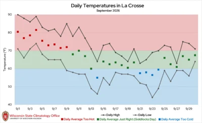
La Crosse also saw plenty of what we call “Goldilocks Days” — days that are neither too hot nor too cold, with an average daily temperature between 60 and 70 degrees. The city recorded 16 of these especially comfortable days this month, all during the latter two-thirds of the month after the early-season heat (Figure 1).
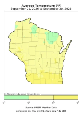
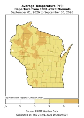
Despite the shift from summer-like heat to cooler fall weather, September leaned decidedly warm. The statewide average temperature for the month was 62.8 degrees, which is 3.3 degrees warmer than the 1991 to 2020 normal and ranks as the 11th-warmest September in Wisconsin since 1895 (Figure 2).
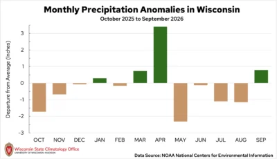
This was the fourth warmer-than-normal month in a row and the seventh warmer-than-normal month of the year (Figure 3).
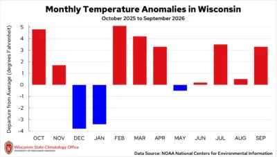
This month also marked the sixth consecutive warmer-than-normal September in Wisconsin. Since 2000, only nine Septembers have been colder than normal.
September was also more humid than average, with a mean statewide dew point temperature of 55.3 degrees — about four degrees above the 1979 to 2026 average. This marked the sixth consecutive September with above-average humidity, consistent with the recent trend: since 2015, every September except 2020 has been more humid than average.
The combination of warmer temperatures and higher humidity may help explain why early fall has increasingly felt like an extension of summer.
A Soaking September…For Most
September was a soggy month for much of the state, though unfortunately the rain didn’t fall where it was needed most. Central and southern Wisconsin were particularly wet, receiving 150 to 300 percent of normal September rain. Meanwhile, the north was left parched once again, with many areas receiving 50 percent or less of typical monthly rainfall. The wet conditions outweighed the dry statewide, giving Wisconsin a monthly average total of 4.38 inches, which is 0.79 inches wetter than normal (Figure 4).
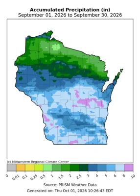
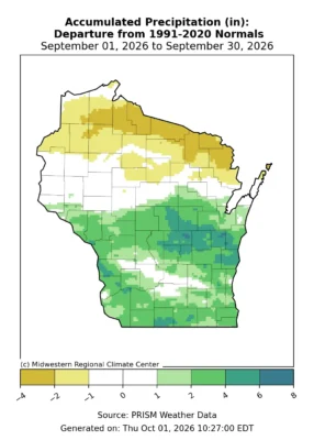
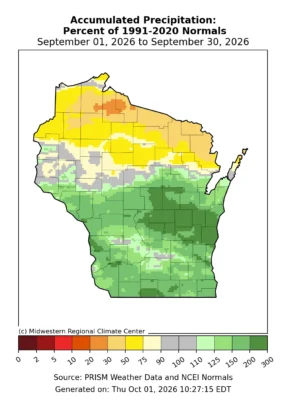
When the rain fell, it often came in buckets. On September 3 and 4, thunderstorms brought downpours to southern and east central Wisconsin. As rain fell at a rate of two to three inches per hour, water covered low-lying roads in the Milwaukee metro and in parts of Sheboygan and Calumet counties. Locations in Outagamie, Manitowoc and Calumet counties reported the highest rain totals: a CoCoRaHS observer near Valders (Manitowoc County) measured 5.48 inches on September 4.
Though totals weren’t nearly as impressive, this weather system did bring some rain to northern Wisconsin. Most received around a half inch of rain, though a few reports in Bayfield County exceeded an inch. For many, this was the first half-inch of rainfall in nearly two months!
Additional downpours from September 14 to 15 dumped rain through central Wisconsin, with totals of one to two inches stretching from La Crosse to Green Bay. While this moisture helped further relieve lingering dryness in the central counties, this region had been in the main path of rainstorms since September 1. In fact, between September 1 and 15, east-central Wisconsin received more than triple its normal rainfall for the first half of September.
A slow-moving weather system brought steady showers to the southern half of the state on September 18 and 19. Widespread totals of one to two inches were reported across the southern counties, with isolated totals exceeding five inches. An observer in Muscoda (Grant County) reported 7.69 inches, while nearby Boscobel measured 6.15 inches.
Milwaukee measured 1.49 inches of rain on September 19, surpassing the daily record of 1.44 inches set in 1997. La Crosse also set a new daily rainfall record of 2.35 inches on September 18, nearly doubling the previous record of 1.26 inches from 2003.
These daily totals nearly equaled the monthly totals seen in Wisconsin’s northern counties. Hurley in Iron County reported only 1.73 inches of rain for the month, the city’s fifth driest since 1987. By contrast, 2026 tied as La Crosse’s 15th wettest September on record, with a monthly total of 7.01 inches. For the state, this was the first wetter-than-normal month since April (Figure 5).
Isolated Rumbles of Thunder
Much of September’s rain came without severe thunderstorms, although rumbles of thunder were heard on numerous days in southern Wisconsin. In fact, La Crosse, Madison, and Milwaukee reported thunder two to four days more than normal in September. Thankfully, aside from a few powerful wind gusts early in the month, September’s storms largely lacked oomph.
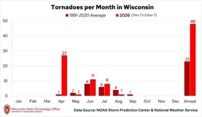
This is typical for September in Wisconsin; as cooler weather settles in, the severe weather season tends to wind down. The state does still average one tornado each September, but none occurred this year (Figure 6).
Drought Moves in Opposite Directions
While heavy rain eased the dry conditions in central and southern Wisconsin, drought intensified across the north (Figure 7).
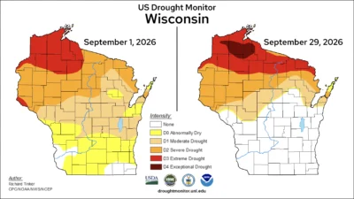
Several rounds of heavy rain across the southern half of the state in the first few weeks of the month brought enough moisture to erase the abnormal dryness (D0) and moderate drought (D1) conditions that were present at the start of the month.
Unfortunately, however, the story was much different in the north. With little to no rain to ease the persistent dryness, drought conditions continued to intensify. Extreme drought (D3) steadily overtook the Northwoods, and by month’s end, expanded from Burnett to Marinette County and points north.
Most notably, on September 22, exceptional drought (D4) — the highest category — overtook some northern Wisconsin counties, such as Douglas, Bayfield, and Ashland counties. This is only the second year in the U.S. Drought Monitor’s history that exceptional drought has occurred in Wisconsin. The first time was in August of 2023.
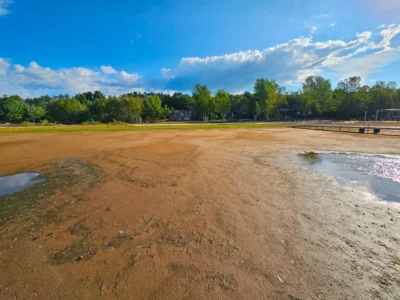
The worsening drought has been felt on the ground. Low water levels continue to be a major concern in lakes, rivers, and reservoirs. The DNR warned boaters to take extra care as some boat ramps and docks become increasingly difficult to access. On the east side of Shell Lake in Washburn County, one resident reported that docks that were sufficiently in the water in June are now completely exposed, along with the lake bed (Image 1).
Warm, shrinking waterways were also stressed aquatic ecosystems, with a fish kill reported on the Red Cedar River near Menomonie. As waterfowl hunting season got underway, the DNR also noted that hunters might find birds in different places than they would normally expect.
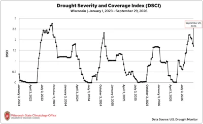
Despite the worsening conditions in the north, the state’s Drought Severity and Coverage Index (DSCI) has slowly but steadily declined, returning to levels last seen in early August (Figure 8).
Harvest Season Takes Shape
September typically marks the start of harvest season for Wisconsin farmers and fall festivities for Wisconsinites.
Hot, humid conditions early in the month helped remaining, non-drought-stricken corn and soybeans continue maturing, while scattered rain provided some benefit to hay fields and pastures. Sadly, pastures across northwestern Wisconsin continued to be burnt out and brown, providing very little feed for livestock and forcing producers to supplement with forage.
By contrast, heavy rain across much of central and southern Wisconsin slowed fieldwork by mid-month and left standing water in some fields.
Fortunately, the drier end to the month allowed farmers to make progress in harvesting row crops as well as planting overwintering crops, like winter wheat and cover crops. However, lingering dryness in some areas raised concerns about whether newly planted seeds would have enough moisture to germinate and establish before going dormant for the winter.
Chillier nights, particularly in northern and even central Wisconsin, also brought frost threats to crops like apples, cranberries, and pumpkins.
Drought is adding another layer of difficulty for cranberry growers in northern Wisconsin, who rely on water for frost protection and for harvesting, but they may face restrictions on water use. Meanwhile, low water levels may be limiting access to wild rice beds and making it difficult to harvest the rice.
For fall farm visitors, the weather was mostly cool and dry for at least two weekends this month. Despite the growing season’s ups and downs with spring frost, heavy rain, drought, and more, Wisconsin’s apple orchards and pumpkin patches showed off the fruits of the season.
The continued heat and humidity in early September helped give apples one more push in size, color, and flavor. However, early-season varieties sold out quickly at some orchards, and a few u-pick orchards had been picked clean by the end of September.
As September turns to October, our attention turns to pumpkin patches. Though some fields may not be as full after a trying growing season, there are reportedly still plenty of perfectly imperfect pumpkins waiting to become jack-o-lanterns.
Climate Ed-ucation
Fall weather typically has a firm grasp on Wisconsin by October, but once in a while, bursts of unseasonable heat can strike. Learn what weather pattern causes these “second summers”, and how often the Badger State experiences them in this month’s Climate Ed-ucation blog.
Climate Stats by Division
Color Key
-
Dark blue: Record coolest
-
Royal blue: Bottom ⅒
-
Light blue: Bottom ⅓
-
White: Normal
-
Light orange: Top ⅓
-
Orange: Top ⅒
-
Red: Record warmest
-
Dark brown: Record driest
-
Light brown: Bottom ⅒
-
Beige: Bottom ⅓
-
White: Normal
-
Light green: Top ⅓
-
Green: Top ⅒
-
Dark green: Record wettest
| Temperature (degrees Fahrenheit)
September 2026 |
Liquid-Equivalent Precip. (Inches)
September 2026 |
Liquid-Equivalent Precip. (Inches)
November 1, 2025 – September 30, 2026 |
||||
|---|---|---|---|---|---|---|
| Division | Avg | Dept | Avg | Dept | Avg | Dept |
| Northwest | 61.2 :Top ⅒ | 3.3:Top ⅒ | 2.70: Normal | -0.86: Normal | 23.84: Bottom ⅓ | -5.53: Bottom ⅓ |
| North Central | 61.0 :Top ⅒ | 3.8 :Top ⅒ | 2.89: Normal | -0.86: Normal | 27.72: Normal | -2.38: Normal |
| Northeast | 60.4: Top ⅓ | 2.7:Top ⅓ | 3.35: Normal | -0.23: Normal | 30.23: Top ⅓ | 1.32: Top ⅓ |
| West Central | 64.3: Top ⅒ | 3.7:Top ⅒ | 5.00 : Top ⅓ | 1.27: Top ⅓ | 29.82: Normal | -2.27: Normal |
| Central | 64.0: Top ⅒ | 3.8:Top ⅒ | 6.07: Top ⅓ | 2.57: Top ⅓ | 34.73: Top ⅓ | 3.55: Top ⅓ |
| East Central | 63.0: Top ⅓ | 2.5:Top ⅓ | 6.30: Top ⅒ | 3.16: Top ⅒ | 33.46: Top ⅓ | 3.72: Top ⅓ |
| Southwest | 65.2: Top ⅒ | 3.4:Top ⅒ | 5.92: Top ⅓ | 2.07: Top ⅓ | 37.02: Top ⅓ | 2.24: Top ⅓ |
| South Central | 65.7: Top ⅒ | 3.6:Top ⅒ | 5.35:Top ⅓ | 1.82: Top ⅓ | 34.38: Top ⅓ | 0.57: Top ⅓ |
| Southeast | 65.2: Top ⅓ | 2.9:Top ⅒ | 5.17: Top ⅓ | 1.84: Top ⅓ | 36.97 Top ⅒ | 4.55 Top ⅒ |
| State | 62.8: Top ⅒ | 3.3:Top ⅒ | 4.38: Top ⅓ | 0.79 Top ⅓ | 30.67 Normal | -0.38 Normal |
Monthly, seasonal, and annual temperature and precipitation values and rankings published in this report are from NOAA’s National Centers for Environmental Information at the time of posting this climate summary. Values and rankings can change after publishing our climate summaries. To check the most recent values and rankings, visit NOAA’s National Centers for Environmental Information Climate at a Glance Tool.
This report is a product of the Wisconsin State Climatology Office. For questions and comments, please contact us by email (stclim@aos.wisc.edu) or phone (608-263-2374).