The arrival of fall can bring mixed emotions: it’s the end of long, warm days and vacations, but it also marks the beginning of a beautiful, cozy season. For most, summer doesn’t officially end until the autumn equinox, but for meteorologists and climatologists, fall begins on September first.
When meteorologists and climatologists talk about the fall season, we use meteorological fall from the start of September through the end of November. The meteorological seasons slice the calendar year into four, three-month chunks based on the annual temperature cycle. This makes it easier to calculate seasonal statistics from year to year.
Temperatures
The Outlook: Leaning Warm
Based on forecasts from NOAA’s Climate Prediction Center, Wisconsin has a chance of seeing warmer-than-average temperatures this fall. The seasonal temperature outlook highlights the chance for unseasonable warmth for nearly the entire United States.
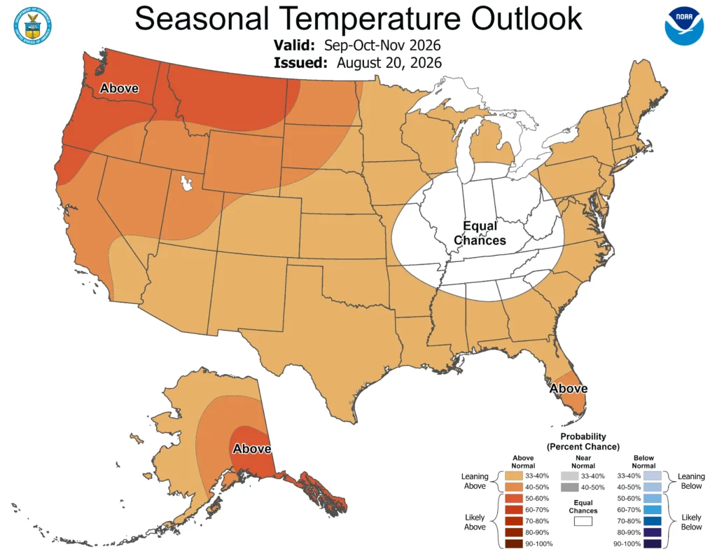
Note that the colors of the above map indicate the probability of above-, below-, or near-average temperatures, not the intensity of the expected warmth or cold.
In this case, Wisconsin has a 33 to 40 percent chance of experiencing above-average temperatures over the three months. Check out this blog for more information on deciphering climate probabilities.
The Averages:
Temperatures cool drastically in Wisconsin through the fall season. The average high temperature falls from 70.6 degrees Fahrenheit in September to just 41.5 degrees in November. Over the three months of fall, the state’s average temperature is 46.6 degrees.
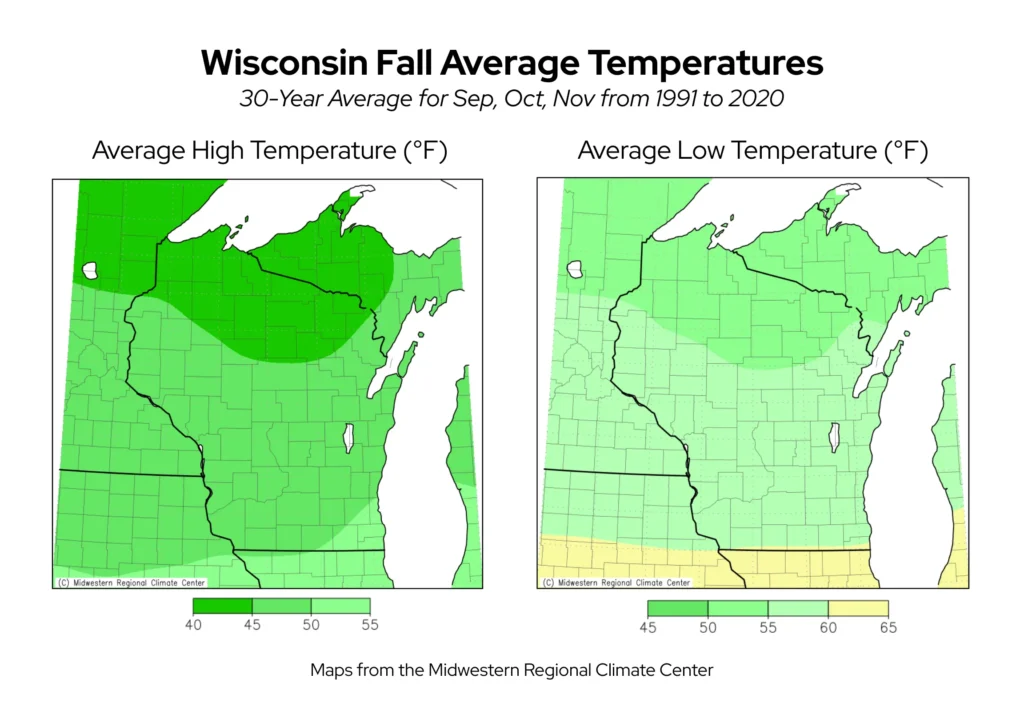
Cooling temperatures through the fall season are crucial in cueing plants and trees to prepare for winter dormancy, leading to the stunning array of autumn leaf colors. Warmer-than-usual fall temperatures, especially at night, can cause leaf colors to turn later or appear more muted.
The Extreme Seasons:
The Badger State’s warmest fall on record was in 2016, during which November was particularly warm. Five daily warm temperature records were broken in Milwaukee, and a toasty 77-degree temperature on November 1 tied as the city’s hottest November temperature since 1871. Northern Wisconsin felt the warmth as well, with high temperatures 17 to 20 degrees warmer than normal during the first week of November 2016. Green Bay and Rhinelander both recorded their warmest November on record.
The last two fall seasons have also ranked in Wisconsin’s top warmest since 1895: 2024 tied for the state’s second warmest, and 2025 was the sixth warmest.
The coldest fall on record was in 1896, when the statewide average temperature was 40.2 degrees — six degrees colder than normal. Mid-October was especially cool, with many locations experiencing temperatures 15 to 20 degrees cooler than normal. A few sites in central Wisconsin reported single-digit temperatures — a minimum of eight degrees in Antigo (Langlade County) on October 18, 1896, remains the location’s earliest single-digit temperature.
Precipitation
The Outlook: To Be Determined
The Climate Prediction Center does not see strong precipitation signals for Wisconsin this fall, giving the state equal chances of experiencing above-, below-, and near-average precipitation. However, a small sliver of northeastern Wisconsin is shaded as potentially leaning drier than normal.
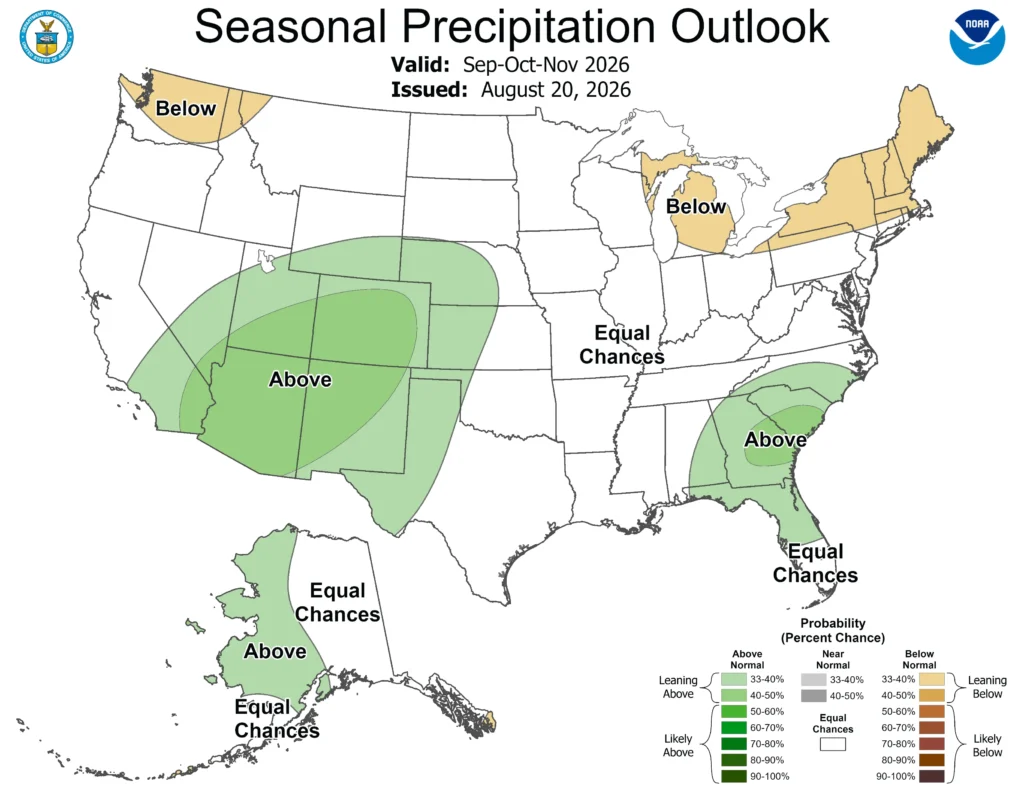
Nationwide, the chance for above-average precipitation in the southwest could alleviate some of the exceptional drought that has spread there over the summer. Unfortunately, the outlook for Wisconsin doesn’t give much promise of improving drought conditions.
The Averages:
Wisconsin typically averages 8.59 inches of precipitation across the state in fall. Central counties are typically the driest during the fall, while northern and southern counties are often wetter.
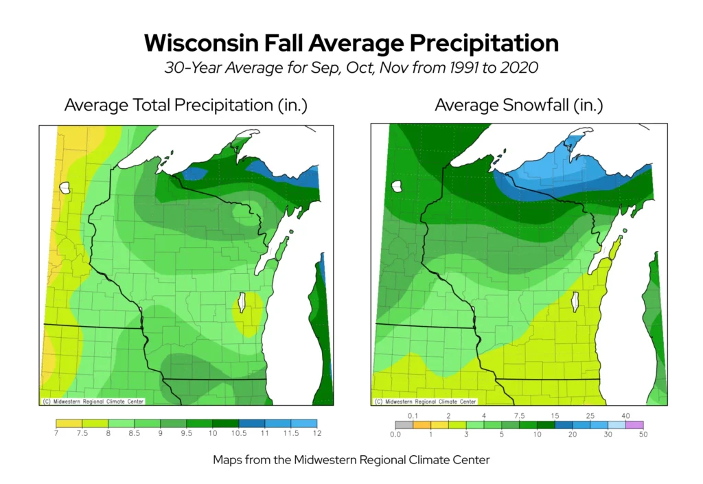
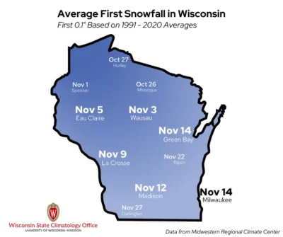
As colder air settles in through October and November, the likelihood that precipitation falls as snow increases. Flakes often begin to fall in the northwest part of the state in late October, but don’t reach the southern regions until mid-November.
As a result, northern Wisconsin receives the most fall season snow, averaging between 10 and 20 inches. Even higher totals can occur in the far northern counties where lake-effect snow is produced by the comparably mild waters of Lake Superior.
The Extreme Seasons:
The Badger State’s driest fall season was back in 1976, when the state averaged only 2.17 inches of precipitation across the three months. Eau Claire was the driest, with only 0.55 inches of precipitation from September 1 through November 30. La Crosse also reported under an inch of precipitation for the season.
Though not nearly as extreme, fall 2025 was also very dry with an average of 5.01 inches of precipitation statewide. The season ranked as Wisconsin’s eighth-driest since 1895. Interestingly, the last six fall seasons have been drier than average, though long-term trends show that Wisconsin falls overall have become increasingly wet.
The wettest fall on record was in 2019, when statewide average precipitation was 13.94 inches! October was especially wet and seemed to be bookended by different seasons.
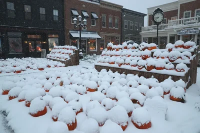
A strong rain system dumped three to five inches across the state on October 2, then a snowstorm brought three to five inches of snow to southern Wisconsin on October 31. Madison recorded its snowiest October with 8.1 inches of snow and its third-wettest October with 5.85 inches of total precipitation. That Halloween was Milwaukee’s snowiest October day, with 5.4 inches of snow falling on the 31st.
The record-wet season made it difficult to harvest field crops, so much so that some farmers continued to harvest into early December. The United States Department of Agriculture reported that both corn and soybean harvests in Wisconsin were the second slowest in their 40 years of records.
This is a product of the Wisconsin State Climatology Office. For questions and comments, please contact us by email (stclim@aos.wisc.edu) or phone (608-263-2374).