September is often one of Wisconsin’s most pleasant weather months, as summer’s heat begins to fade but winter’s bite hasn’t set in yet. Trees gradually begin changing color, with leaves in northern Wisconsin often reaching their peak by the end of the month.
Temperatures
The Outlook: Trending Warm
Based on forecasts from NOAA’s Climate Prediction Center, summer may not be ready to let go just yet. The outlook shows a chance of warmer-than-average temperatures in Wisconsin in September. Much of the central United States could see abnormal warmth, with especially high chances in Kansas and Oklahoma.
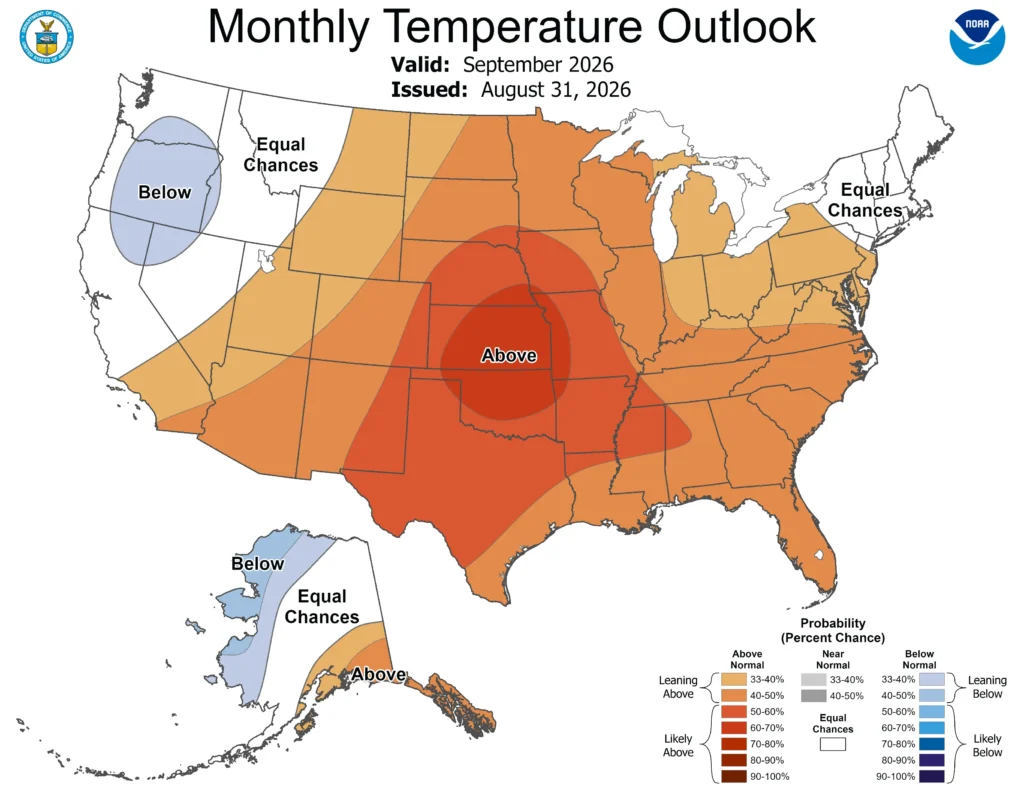
Note that the colors of the above map indicate the probability of above-, below-, or near-average temperatures, not the intensity of the expected warmth or cold.
In this case, Wisconsin has a 40 to 50 percent chance of experiencing above-normal temperatures. Check out this blog for more information on deciphering climate probabilities.
The Averages:
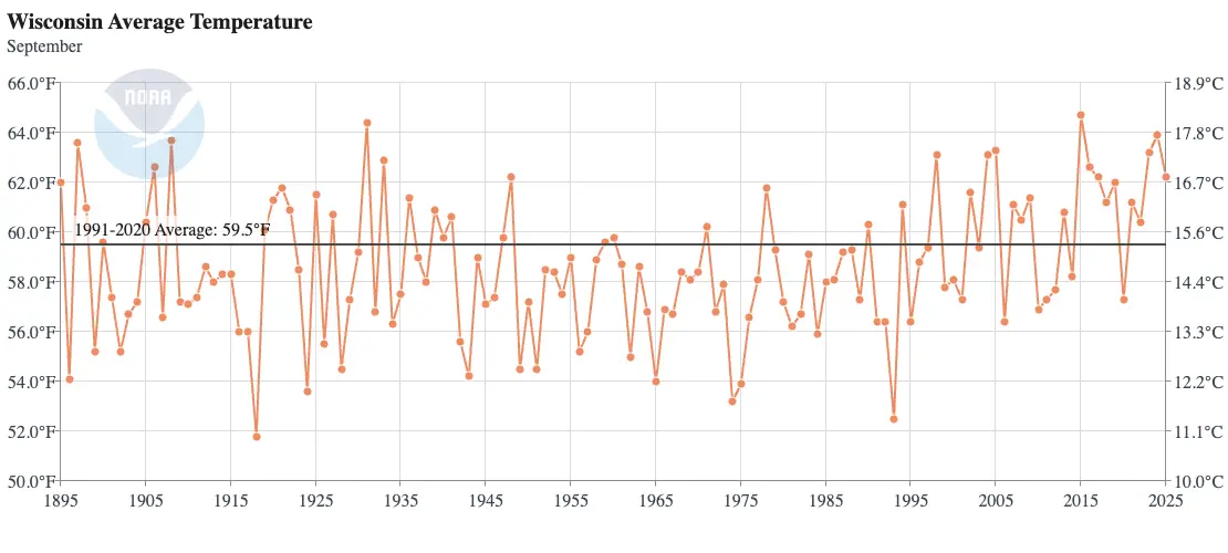
Wisconsin’s average temperature in September is just below 60 degrees. Temperatures change significantly throughout the month: the beginning of September often feels more summer-like, while the end of the month can take on a brisk, autumn feel.
The warmest September was in 2015, when the average temperature across the state was 64.7 degrees. September of 2024 was also exceptionally warm: the statewide average temperature was 63.9 degrees, and the average high temperature was a hot 77 degrees!
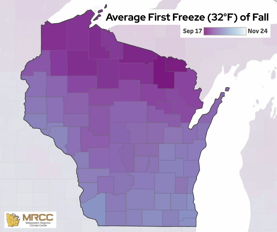
Many locations in northern Wisconsin experience the first freeze of the season before October 1. Forest County in the northeast region averages the earliest first fall freeze on September 20.
September 1918 brought the coldest conditions to the state — the average low temperature in the state was in the upper 30s. The coldest day of that month was September 30, when the northwest region woke up to temperatures in the teens while the central part of the state reported temperatures in the upper 20s. The first cases of Spanish Influenza were reported in Wisconsin around this time, and it’s possible that the unusually cold conditions aided in the rapid spread of the virus.
Precipitation
The Outlook: To Be Determined
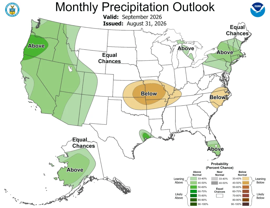
The Climate Prediction Center is not seeing any strong precipitation signals for Wisconsin, giving the state equal chances of experiencing above, below, or near-average precipitation in September. This unfortunately doesn’t offer high hopes of drought-busting rain for the northern part of the state.
The Averages:
Thunderstorm activity decreases through September, and the state begins to dry out. Drier stretches during this month are crucial for farmers looking to harvest, as both the crop and the soil need to be sufficiently dry. However, too little precipitation during the month can limit soil moisture storage going into the winter season.
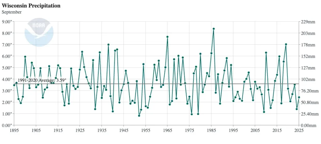
The last six Septembers have been drier than average, with 2024 ranking as the eighth driest September since 1895. The driest September on record was in 1952, when the average precipitation total across the state was 0.83 inches. Milwaukee, Madison, La Crosse, Wausau, and Green Bay received less than a half inch of rain that month.
By contrast, the soggiest September in Wisconsin was in 1986 when many locations in the central region of the state measured over a foot of rain! Beaver Dam in Dodge County reported the highest monthly total of 15.05 inches. The statewide average precipitation was 8.38 inches.
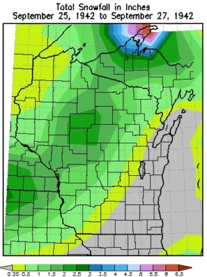
It’s not unheard of for a few flurries to fall across the northern counties in late September, but most of the state has until October before the white stuff begins to appear.
However, an unusual snowstorm in 1942 brought inches of snow to the western and central parts of the state from September 26 to 27. The highest total was 6.3 inches, reported north of Eagle River in Vilas County — that’s the largest amount of snow measured in Wisconsin in September. Most Wisconsinites will likely agree that we don’t want to give that record a run for its money any time soon!
This is a product of the Wisconsin State Climatology Office. For questions and comments, please contact us by email (stclim@aos.wisc.edu) or phone (608-263-2374).