Wisconsin is often battered by severe thunderstorms that produce damaging straight-line winds, tornadoes, large hail, and torrential downpours.
Some clusters of thunderstorms may not spawn tornadoes but can still produce widespread, devastating damage. These long-lived storm complexes stretch miles wide and have straight-line winds that can be near hurricane-strength. Such a complex is called a derecho (pronounced deh-REY-cho), the Spanish word for “straight ahead” or “right”.
Historic Background
The term derecho was first used in a meteorological context in an article published in the American Meteorological Journal in 1888 by Dr. Gustavus Hinrichs, a professor at the University of Iowa. Hinrichs founded the Iowa Weather Service in 1875, which contained a network of sixty volunteer weather observers across the Hawkeye State.
Using information from his observers, Hinrichs analyzed a rapidly moving and vigorous line of thunderstorms that traveled to the east-southeast across the state in July 1877 and caused widespread damage that was unlike that of a tornado. He concluded that the storm contained strong straight-line winds rather than tornadoes. To avoid confusion, he coined the word derecho to distinguish it from the “turning or twisting” pattern associated with tornadoes.
Identifying Derechos
Derechos differ from the typical squall lines in terms of size and shape, wind strength, and lifespan. While a squall line is usually a long and relatively straight wall of thunderstorms, a derecho often has a pronounced curved shape on weather radar and tends to accelerate with time.
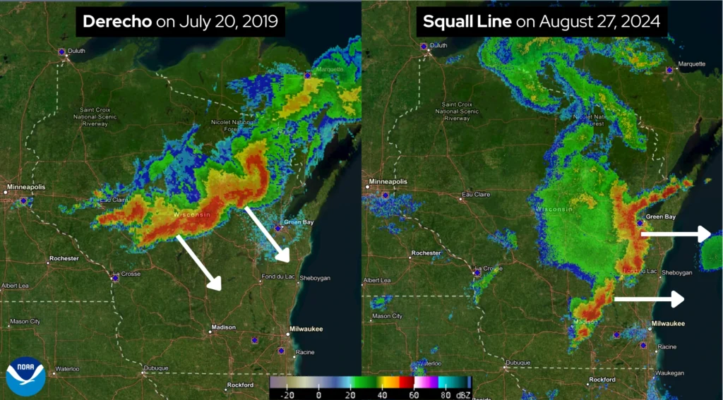
One of the original criteria for a derecho was that winds were to be at least 58 miles per hour during its lifespan. The storm path itself was to extend for at least 400 miles from west to east and persist for many hours.
In 2025, the official definition of a derecho was modified based on recent research. The new criteria require a specific physical development of the storm system, objective identification, and a higher wind threshold. This shifts derecho identification away from the earlier, report-based criteria.

This new derecho definition specifies that the event is a widespread severe windstorm complex producing a family of destructive downbursts with frequent sustained wind speeds exceeding 58 miles per hour, along with several gusts of 75 miles per hour or greater. The damage path must extend more than 250 miles — roughly the distance from Eau Claire to Milwaukee.
These new criteria, along with new meteorological specifications for how the storm develops, allow for faster identification of derecho events.
How Derechos Form
Several ingredients are necessary for derechos to form. As thunderstorms begin to form, the air ahead of the system must be unstable to allow the storms to intensify. Heat and humidity often provide instability in the atmosphere, and humidity can also provide extra moisture to produce torrential downpours.
These downpours under the parent thunderstorm pull cold air downward to the ground as downdrafts. Although downdrafts typically cause a thunderstorm to weaken, in cases where a derecho forms, they can help create new thunderstorm cells. This allows the line of storms to sustain itself for hundreds of miles.
Derecho Climatology
Derechos most frequently form and track across the central and eastern United States, including the Midwest and Ohio Valley, the Northern Plains, and the Southern Plains. Wisconsin’s location in the Midwest means that many of its derechos originate in nearby Midwest states, most commonly Iowa.
The Wisconsin State Climatology Office developed its derecho climatology for the Badger State using the National Oceanic and Atmospheric Administration (NOAA)’s Storm Prediction Center (SPC) archive. This state archive runs from 1960 through 2025. During these 65 years, between 38 and 45 derechos have been documented across Wisconsin, representing slightly more than 25 percent of the total number of derecho events nationwide.
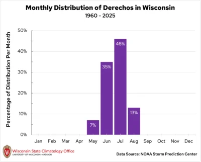
In Wisconsin, derechos are most common from May through August, aligning with the state’s typical severe weather season. Derechos have occurred most frequently in July. It is rare for these storms to occur outside these four warm months.
More than half the derechos that have affected Wisconsin occurred during the evening, with the fewest occurring in the morning.
Due to its often hotter and more humid environment, southern Wisconsin is more frequently impacted by derechos than the northern region. More than half of the documented derecho wind swaths across Wisconsin were in the southern half of the Badger State, generally in a line from La Crosse to Manitowoc. Counties across southern Wisconsin can have one to two derecho events every decade, including three counties along the Illinois state line that could have two or more derechos every ten years.
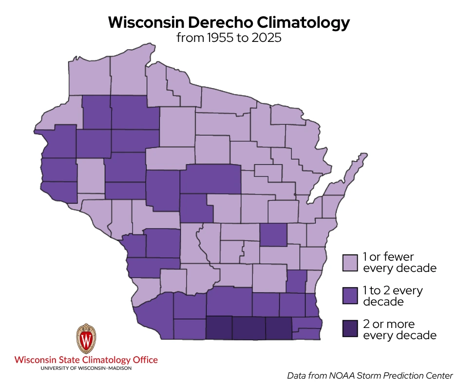
Several other counties across western and central areas of the state may have one to two derechos per decade, while the remaining counties across central, eastern, and northern Wisconsin have one or fewer derecho events every decade.
Wisconsin’s Derecho Extremes
One of the longest-duration derechos took 28 hours to travel from west-central Minnesota across Wisconsin before reaching the Carolinas in July 2015. The Right-Turn Derecho of July 12-13, 1995 had the longest path length, as it traveled from eastern Montana through northern Wisconsin and Michigan’s Upper Peninsula before turning south and dissipating over southern Ohio, a distance of approximately 1,500 miles.
The fastest derecho wind speed measured in Wisconsin was a 128-mile-per-hour wind gust measured in Dodge County during the May 30–31, 1998 Southern Great Lakes Derecho — this is also the record for the strongest measured wind gust on record in the state!
Since 1955, as many as eight people in Wisconsin have been killed by derechos, and 128 people have been injured.
Memorable Derechos in Wisconsin
Over the last seven decades, several destructive and historic derechos have struck the Badger State. Some of these memorable derechos include:
The Independence Day Derecho — July 4, 1977
A long-duration severe thunderstorm event on the Fourth of July 1977 left a trail of destruction across northern Wisconsin, extending from Burnett County eastward across Washburn, Sawyer, Price, and Oneida Counties. At the time, the term derecho was not used, but more than a decade later, this holiday severe storm was identified as such.
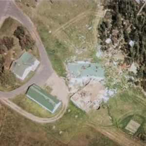
The Independence Day Derecho developed in western Minnesota on the morning of the Fourth, before traveling across northern Wisconsin and ending over Lake Michigan. The storm traveled nearly 700 miles in 12 hours.
Peak thunderstorm winds along the path were estimated near 135 miles per hour in Sawyer County, with 100-mile-per-hour wind speeds measured in Price and Oneida counties. The storm damaged nearly every home in the city of Phillips (Price County). Unfortunately, 35 people were injured, and one woman was killed on Conners Lake (Sawyer County) after a tree fell on her camper.
The Western Wisconsin Derecho — July 15, 1980
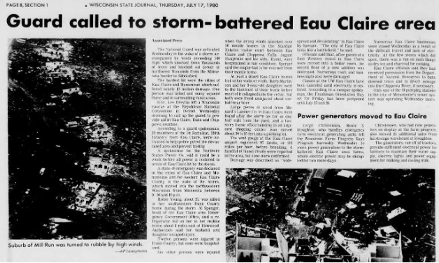
The Western Wisconsin Derecho (also known locally as “The Storm”) caused the largest storm damage in state history at that time. Total damage was determined at $160 million (nearly $625 million in 2025). The storm system originated in South Dakota and traveled eastward across western and central Wisconsin on the evening of July 15, 1980.
The path of destruction was over 100 miles long and between 20 and 40 miles wide, impacting Pierce, Eau Claire, Clark, Jackson, and Portage counties. Storm winds were estimated to have reached 112 miles per hour in Eau Claire. The system spawned 10 tornadoes, including one F3 tornado in Eau Claire County. Three people died, and nearly two dozen were injured because of the tornadoes.
It was an unfortunate double-feature as a separate derecho formed across eastern Iowa early on the following morning, July 16. The storm traveled across southern Wisconsin and northern Illinois before crossing Lake Michigan and ending near the Detroit metropolitan area. The storm covered an impressive 425 miles in just six and a half hours. Some damage was sustained across Rock, Racine, and Kenosha Counties.
The Southern Great Lakes Derecho — May 30-31, 1998
The 1998 Southern Great Lakes Derecho swept across south-central and southeastern Wisconsin early on May 31, 1998. This storm formed over Minnesota on May 30 and ended in Michigan eleven hours later, the following morning.
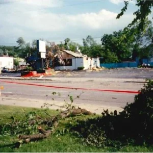
Twenty Wisconsin counties were hard hit. A peak wind gust of 128 miles per hour was measured in the town of Lebanon in southeastern Dodge County. Additional measured wind gusts in the area exceeded 100 miles per hour. Seven tornadoes also touched down in the state.
Three people were killed by this derecho, while eight people were injured. A total of 193 residences sustained damage, and over 300 farm buildings were damaged or destroyed. An estimated $60 million in property losses and $1.82 million in crop damage were sustained.
The Northern Wisconsin Derecho — July 19, 2019
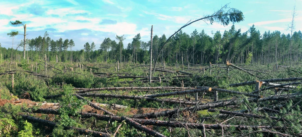
The July 19, 2019 storm is considered a historic and severe Wisconsin derecho, as a massive 15-mile-wide downburst produced winds over 100 miles per hour across northern Wisconsin. These winds flattened between 150,000 and 250,000 acres of timberland, especially across the Chequamegon-Nicolet National Forest and Oconto County. In addition, over 500,000 people were left without power across the region. Seven tornadoes accompanied the derecho, impacting areas from Polk to Marathon counties.
The Midwest Derecho — August 10, 2020
This Midwest Derecho, called “The Most Expensive Thunderstorm Event in Modern U.S. History,” traveled nearly 700 miles on August 10, 2020, running from eastern South Dakota and Nebraska to western Ohio.
The strongest wind speeds associated with this system were estimated to be 140 miles per hour near Cedar Rapids, Iowa. With nearly 600 reports of wind damage across the Midwest, the storm inflicted an estimated $13.5 billion in damage. In addition, more than 25 tornadoes accompanied this derecho as it charged across the Midwest.
Although Iowa and Illinois sustained more damage from this derecho, southern Wisconsin also experienced considerable damage. Across the southern counties, 46 instances of strong winds were reported. Two EF-0 and one EF-1 tornadoes touched down in Grant, Walworth, and Kenosha counties. The Badger State reported an estimated $388,000 in property loss due to the storm.
This report is a product of the Wisconsin State Climatology Office. For questions and comments, please contact us by email (stclim@aos.wisc.edu) or by phone (608-263-2374).