April 2023 in Wisconsin saw wild temperature fluctuations and above-normal precipitation, including record snowfall in some areas.
A Tale of Two Aprils
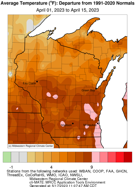
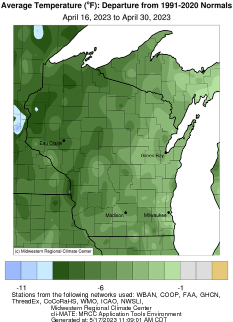
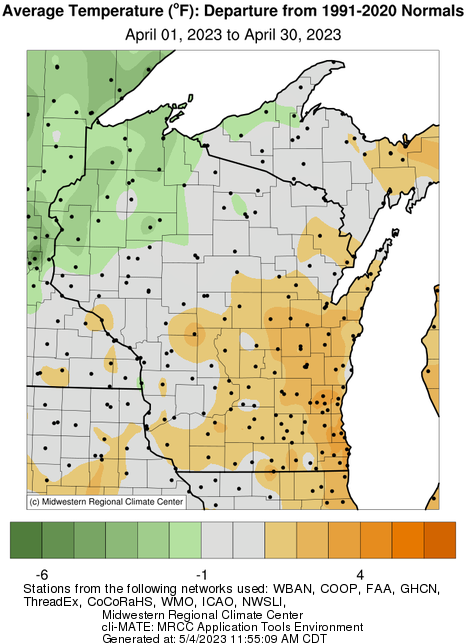
The month provided a very memorable roller coaster ride in Wisconsin. Although the monthly average temperature of 43.4°F was only 0.3 Fahrenheit degrees shy of the 1991-2020 average, the real story is how the month split evenly between an exceptionally warm first half and a remarkably cold second half. Statewide, temperatures averaged 8 Fahrenheit degrees warmer than normal from April 1-15 but flipped to 8°F colder than normal from April 16-30.
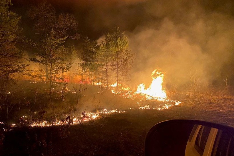
The warm half featured an early heat wave from the 11th to the 15th, with four straight days of 80°F or higher in Eau Claire, Wausau, Green Bay, La Crosse and Madison. La Crosse even reached 90°F on the 12th — the second earliest date on record. This dramatic early-season heat coincided with very dry air and strong winds to necessitate red flag warnings for fire danger. These concerns came to pass with numerous wildfires flaring in central and western Wisconsin, especially those near Necedah Wildlife Refuge and Fort McCoy.
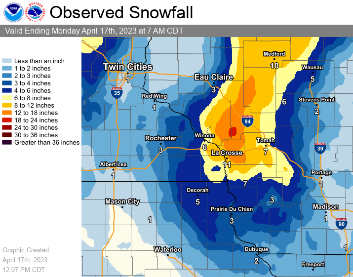
But weather whiplash quickly ensued, leading to record snowfalls just a few days later in much of the same region. Widespread totals of more than a foot occurred on the 16th-17th, and many stations reported at least 1.5 feet. The highest amount of 22 inches fell in Northfield (Jackson County).
An unfortunate consequence of April’s volatility is the devastating effect the temperature swings had on Wollersheim Winery in Prairie du Sac, where almost the entire red grape crop was lost after the early warmth caused premature budding of the vines, followed by freezing conditions that killed many of the plants.
(Click thumbnails to view larger versions)
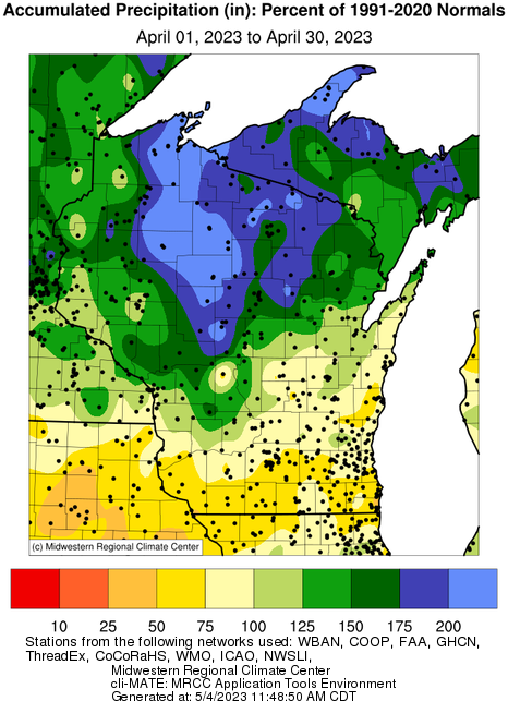
Yet Another Wet Month
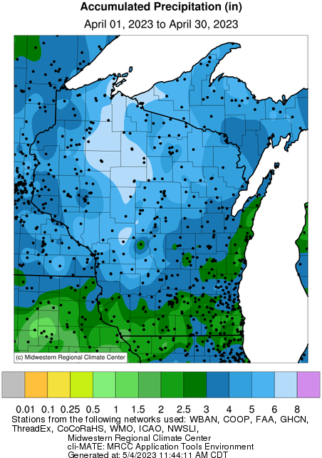
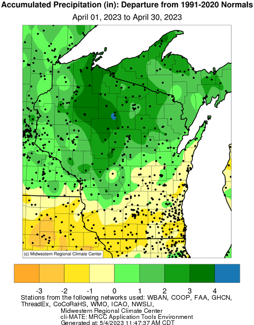
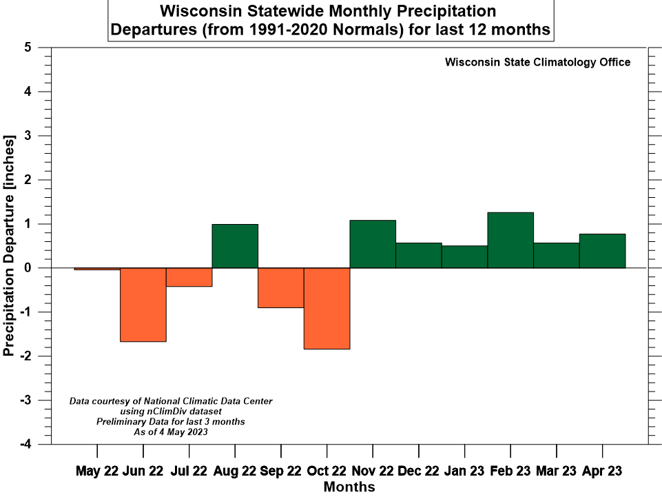
Precipitation was above normal during April in Wisconsin for the sixth consecutive month. The 3.97 inches that fell was 0.77 inches higher than normal (+24%) and placed the month as the 17th wettest April out of 129 on record. April’s precipitation pattern varied strongly by latitude, with the north very wet but the south drier than average. The very wettest climate regions were the northwest and northcentral, much of which received more than twice the normal April precipitation — a lot of it as snowfall — whereas all three southernmost climate divisions were actually drier than average.
The consistency of the wet anomalies since November is exceptional, as all months since then show positive anomalies of at least half an inch and as much as 1.26 inches in February. Our current streak of six straight wet months (relative to 1991-2020 normals) has only been matched twice since records began in 1895. Both occurrences were recent: a 9-month string from December 2016-August 2017 and a 7-month string from December 2012-June 2013.
Furthermore, the first four months of 2023 (Jan-Apr) were the wettest in Wisconsin since reliable statewide records began in 1895, since the accumulated liquid-equivalent precipitation for the year-to-date (through April) averaged across the state was 10.47 inches.
Thanks to the abundance of long-term precipitation, Wisconsin’s soils ended the month with plenty of moisture to start the growing season. Only 1% of the state reported a shortage of topsoil or subsoil moisture, whereas about two-thirds of regions were deemed adequate and approximately one-third recorded a surplus (according to the USDA’s National Agricultural Statistics Service’s weekly Crop Progress & Condition Report).
(Click thumbnails to view larger versions)
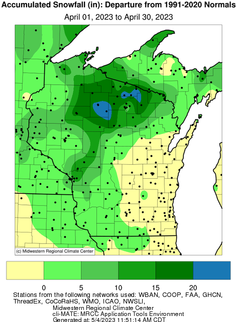
A Flaky April!
Despite the warm-up into April, the month added a surprising amount to the 2022-23 seasonal snowfall totals. In addition to the mid-April snowstorm that affected western Wisconsin, the northern part of the state continued to pile up snow during April, with most of the northcentral region exceeding 20 inches and Phelps in Vilas County reporting a whopping 34 inches!
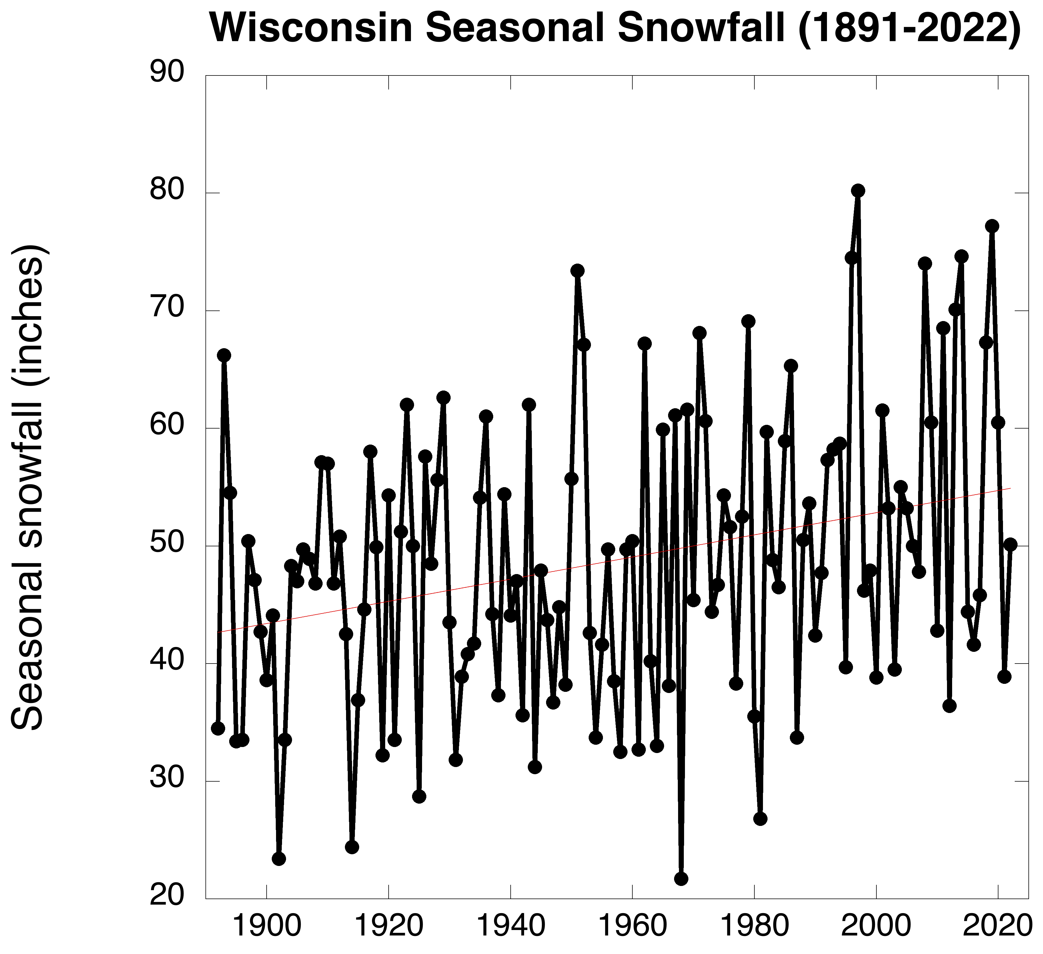
The impressive April snowfalls helped several locations reach record-high snowfalls for the 2022-23 season. For example, Rhinelander (Oneida County Airport) at 123 inches and Bayfield (Fish Hatchery) at 183 inches set new records. This year’s abundant snowfall is consistent with an apparent long-term increase since statewide records began in the 1890s. Based on the reported data, Wisconsin has seen an uptick of 12 inches since then, including several extremely high totals in the past 25 years. However, there are questions as to whether changes in measurement methods might be biasing the positive trend (Kunkel et al., 2007). This question makes for an interesting research topic to be pursued by the State Climatology Office.
(Click thumbnails to view larger versions)
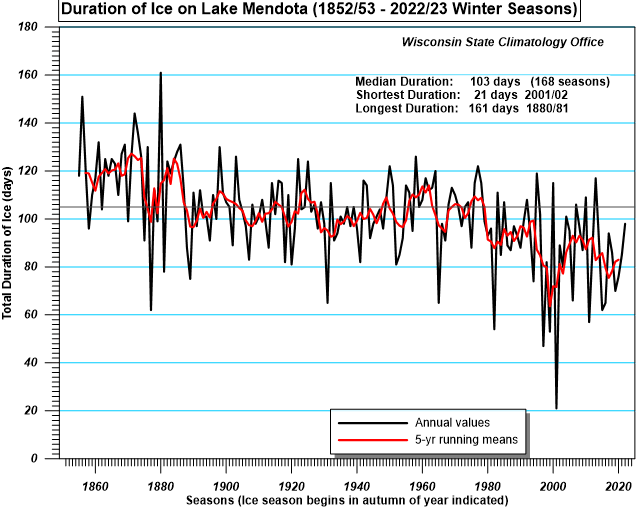
Lake Mendota Sheds Its Ice
A more certain long-term climate trend is the decline of ice cover on Madison’s Lake Mendota, which has unbroken data of ice-on and ice-off dates since 1852. This remarkable 170-year long record shows a clear-cut indication of the warming climate, at least in southern Wisconsin. During this winter season, Mendota iced over on December 25 and melted off April 2, yielding an ice duration of 98 days. This is somewhat less than the long-term median of 103 days.
The graph below shows the overall decline in Mendota’s ice duration over time, despite the high year-to-year variability superimposed. The average duration during the 19th century was 114 days, which shrank to 101 days during the 20th century and dropped further to 90 days in the 21st century.
The ice duration is affected much more closely by local air temperature than any other accompanying weather variable such as wind, humidity, snowfall, or cloudiness. Lake Mendota’s ice record thus represents a long-term climate “proxy” that even predates Madison’s official temperature measurements that began in 1869.