Wisconsin’s 2024 weather was warm, wet, and wavering, leading to the warmest year on record and precipitation ping-pong between record dry and record wet months.
Record-Breaking Warmth
This past year was officially the warmest year on record (since 1895) for Wisconsin, with a statewide average temperature of 47.6 degrees (Fahrenheit) — 3.8 degrees above the 1991 to 2020 normal (Figure 1). This surpassed the previous record of 47.4 degrees, set in 2012.

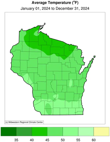
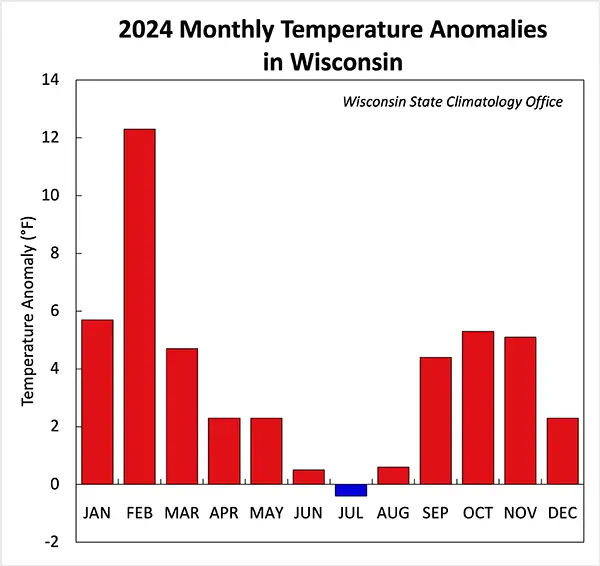
In fact, warmer-than-normal conditions dominated the whole country, with pronounced temperature anomalies coating the upper Midwest and northeastern United States (Figure 2) as part of the nation’s warmest year on record. In Wisconsin, most areas experienced temperatures three to four degrees above normal, and a few pockets even reached four to five degrees above normal (Figure 3). The second warmest February on record contributed significantly to the year’s exceptional warmth (Figure 4). Just like 2023, July was the only month cooler than normal, but only by 0.4 degrees.


Temperature Extremes
The highest temperature recorded in Wisconsin in 2024 was 98 degrees, recorded on August 26 (Mondovi, Buffalo County) and August 28 (Brodhead, Green County; Beloit, Rock County). The lowest was minus 25 degrees in Butternut (Ashland County) on December 13 and 14.
Notably, minus 25 degrees ties for the state’s second mildest annual minimum temperature on record. Wisconsin’s annual temperature range — the difference between the year’s very highest and lowest temperatures — was the smallest on record in 2024 at 123 degrees (Figure 5).

Historically, annual ranges often exceeded 130 degrees, with lowest temperatures in the minus 30s or below and highest temperatures above 100 degrees. However, there has been a consistent narrowing in recent decades, a trend which results from a cooling of the annual maximum and warming of the minimum temperatures.
Precipitation Ping-Pong: Round 2
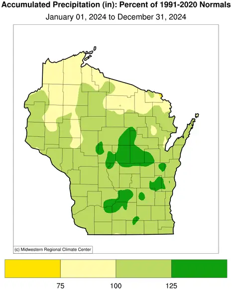
Wisconsin also saw a notably wet year in 2024, ranking as the 13th wettest on record with a statewide average of 37.0 inches, compared to the normal of 34.05 inches. This included the very wettest March-through-August period on record (Figure 6).
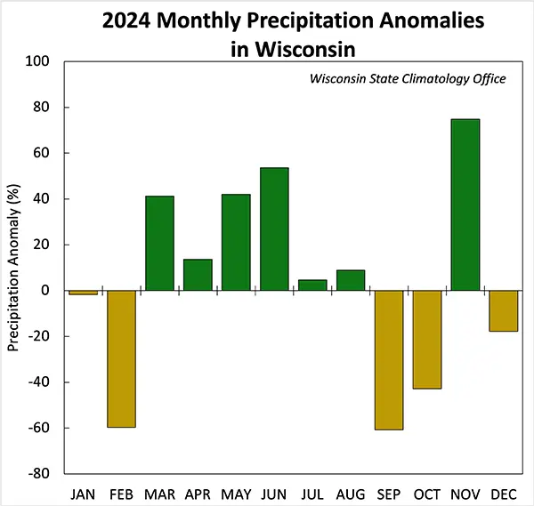
However, conditions quickly switched to the sixth driest September-through-October on record, representing another “precipitation ping-pong” pattern like what Wisconsin experienced in 2023.
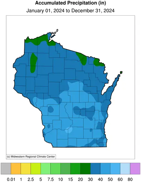
For the year as a whole, wetter-than-normal conditions were felt across much of the state, particularly in central and southern counties (Figure 7). Northern Wisconsin, however, experienced drier-than-normal conditions in 2024, contributing to regional variability.

Top 10 Wisconsin Weather and Climate Events in 2024
Warmest Winter on Record
Dubbed a “Lost Winter,” December 2023 through February 2024 was the warmest winter since records began in 1895, with impacts including a snow drought, early maple tree tapping, and the second shortest ice duration on Madison’s Lake Mendota. The only hint of winter came during a brief two-week cold snap in mid-January.
Freaky February
February 2024 was one of the most eventful months in Wisconsin’s weather history, featuring the state’s first February tornadoes and spring-like warmth that culminated in Wisconsin’s highest temperature ever recorded during the meteorological winter season when Kenosha reached 77 degrees on February 27. However, temperatures plummeted the following morning, setting a record for the largest 24-hour temperature fall at multiple locations, including Milwaukee, which dropped from 74 to 23 degrees.
Record Snowfall in April
A powerful early April snowstorm brought record-breaking snowfall to Wisconsin, including 15 inches in Shiocton and 17 inches in La Crosse over two days. The storm caused widespread havoc by disrupting rush hour traffic, raising Green Bay’s water levels by over two feet, and leaving over 100,000 households without power.
Very Wet Spring and Early Summer
May-to-June rainfall set a statewide record with 12.51 inches between the two months. June was especially soggy, ranking as the sixth wettest on record, with La Crosse seeing rain on 24 days and localized downpours such as the 4.81-inch deluge at the University of Wisconsin–Madison Arboretum on June 19.
Extreme Daily Rainfalls
Short-lived but intense rainfall events in July caused flash flooding, a dam breach in Waupaca County, and a state of emergency declaration in four counties. On July 14, Madison set a record for rainfall intensity, when 2.23 inches fell in one hour. The city was struck again two months later with nearly four inches of rainfall on September 21, becoming Madison’s wettest September day on record.
Slew of Tornadoes
Tornadic weather dominated spring and summer, highlighted by the May 21 outbreak, which produced 16 tornadoes, including the first ever on Washington Island. A tornado near Cochrane leveled a century-old barn, and Madison endured its worst power outage since 1976, affecting 42,000 customers.
Late August Heat Wave
A late-August heat wave generated the year’s hottest temperature of 98 degrees at Beloit, Brodhead, and Mondovi. The absence of 100-degree days in 2024 continues a recent decreasing trend in triple-digit heat in Wisconsin, despite such extremes being common historically.
September’s Compound Extreme
September was an exceptionally extreme month, ranking third warmest and sixth driest on record. The last time Wisconsin experienced this kind of “compound extreme” month (landing among the 10 warmest and driest) was March 2016. Based on Wisconsin’s long-term data since 1895, there have only been 31 compound extreme months of any combination (warm-dry, warm-wet, cool-dry or cool-wet).
Late Summer to Early Fall Drought (and Warmth)
Drought intensified from late August to October, leading to all of Wisconsin becoming drought-stricken for the first time since the U.S. Drought Monitor began in 2000. Unseasonable warmth worsened conditions, with Madison and Green Bay reaching record-late 80-degree readings on October 29, nearly 30 degrees above average.
Warmest Year on Record
The year 2024 was officially Wisconsin’s warmest year on record, with a statewide average temperature of 47.6 degrees, surpassing the previous record of 47.4 degrees set in 2012. February stood out as the most unusually warm month (12.2 degrees above average), whereas July had the distinction of being the only cooler-than-normal month of the entire year — and by just 0.4 degrees.
Steve Vavrus is the Wisconsin state climatologist. Bridgette Mason and Ed Hopkins are the assistant state climatologists.