As we transition from May into June, we bid farewell to spring and say hello to summer. June’s long and (typically) warm days offer Wisconsinites many opportunities to get outside and enjoy outdoor activities. However, the warmth also elevates our chances of getting thunderstorms. What will June 2026 have in store for us? Let’s take a look!
Temperatures
The Outlook: Leaning Warm
NOAA’s Climate Prediction Center is predicting above-normal temperatures for Wisconsin this June. This is the case for most of the Midwestern states. Further to the west, the odds of a warmer-than-normal June are even greater. Across the southeast and south-central states (excluding Florida), temperatures are more uncertain with “equal chances” for above-, near-, or below-normal temperatures.
Note that the colors of the above map indicate the probability of above- or below-average temperatures, not the intensity of the expected warmth or cold. For example, Wisconsin has a 40 to 50 percent chance of above-normal temperatures during June.
Check out this blog for more information on deciphering climate probabilities.
The Averages
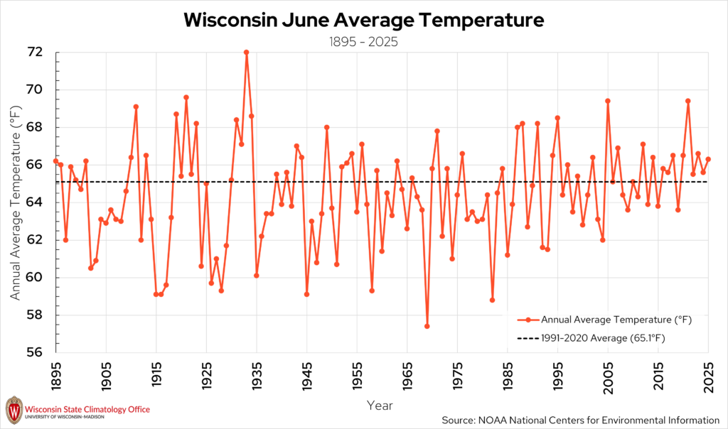
Wisconsin’s average temperature for June is 65.1 degrees Fahrenheit. High temperatures range from the low 70s in the north to the upper 70s in the south. By June, most of Wisconsin is out of the woods for having overnight lows below freezing, but a sub-freezing night is not out of the question in northern counties.
Extreme heat is a risk to Wisconsinites of all ages, and June is the month when Wisconsin cities typically see their first 90-degree day of the year. La Crosse observes the highest average number of 90-degree days in a year (17) compared to the other first-order stations.
Location |
Average First 90°F Day of the Year |
| La Crosse | May 26 |
| Eau Claire | June 6 |
| Milwaukee | June 13 |
| Madison | June 26 |
| Wausau | June 26 |
| Green Bay | June 30 |
| The average date of the first 90-degree temperature of the year at Wisconsin’s six first-order stations, based on data from 1991 to 2020 | |
June of 1933 was the hottest June on record in Wisconsin, with a statewide average temperature of 72.0 degrees Fahrenheit. 100-degree days were observed across all parts of Wisconsin. Even stations as far north as Burnett and Douglas Counties reached 100 degrees that month. Days that reached 90 degrees were very common in June 1933, with the cities of Eau Claire (19 days), La Crosse (15 days), and Wausau (13 days) topping the list.
More recently, June of 2021 tied for the third-warmest June on record, with an average temperature of 69.4 degrees. That month, La Crosse had 14 days that reached 90 degrees, and Eau Claire had 11 days.
Wisconsin’s coldest June on record occurred in 1969, with a statewide average temperature of 57.4 degrees Fahrenheit. None of Wisconsin’s first-order stations hit 90 degrees during that month, and some stations in the far north dipped down into the upper 20s overnight.
Precipitation
The Outlook: Continued Dryness
NOAA’s Climate Prediction Center predicts that most of Wisconsin will experience below-normal precipitation for the month of June, especially in the far eastern counties. Further to the west, the precipitation probabilities do not show a lean towards above-, near-, or below-normal rainfall. The odds for below-normal precipitation are highest in Michigan as well as in the Pacific Northwest. New Mexico has the highest odds of above-normal precipitation this June, and the southeast coast is also predicted to be wetter-than-normal.
The Averages:
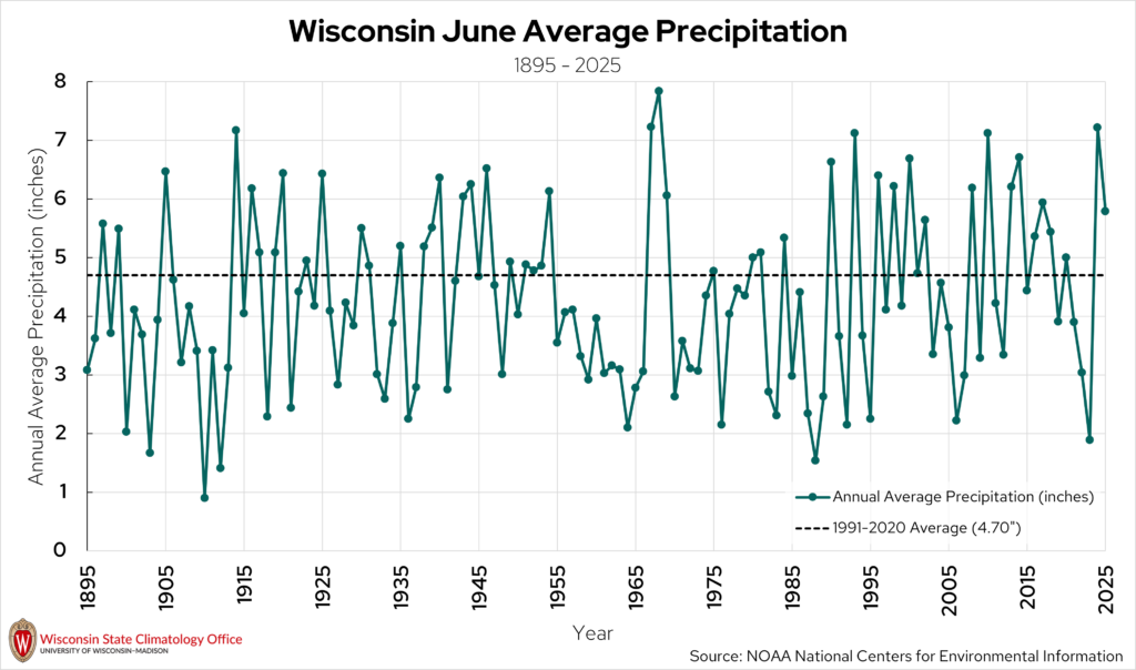
June is Wisconsin’s wettest month of the year, with an average monthly precipitation total of 4.70 inches. Precipitation in June doesn’t always come as a gentle rain, as June is Wisconsin’s second-most active month for severe weather (just behind July). Heavy precipitation events are not uncommon during the month of June in Wisconsin, sometimes dropping multiple inches in just one day.
Location |
Average Number of Heavy Rain Events (2 inches or more) in June |
| Madison | 12 (48) |
| Eau Claire | 8 (31) |
| Milwaukee | 7 (37) |
| La Crosse | 7 (32) |
| Wausau | 7 (25) |
| Green Bay | 0 (17) |
| The number of precipitation events of 2 inches or more at Wisconsin’s six first-order stations that occurred in June from 1991 to 2020. The value in parentheses is the total number of precipitation events of 2 inches or more between 1991 and 2020. | |
Wisconsin’s wettest June on record occurred in 1968, with a statewide average precipitation total of 7.84 inches. The wettest cities that month were Ladysmith (13.70 inches at the Big Falls Hydro station), Cashton (11.95 inches), and Weyerhaeuser (11.93 inches).
More recently, Wisconsin has experienced several very wet Junes. For instance, June 2024 was the third wettest June on record (7.22 inches), which created challenges for farmers. June of 2010 was the sixth wettest on record (7.12 inches), and June 2014 was the seventh wettest (6.71 inches). Folks in southern Wisconsin may recall the heavy rainfall of June 2008, which brought about severe flooding.
On the flip side, June of 1910 was the driest June on record in Wisconsin, with a statewide average precipitation total of less than one inch (0.90 inches). That month, La Crosse received less than a half-inch of precipitation.
Just a few years ago, June of 2023 ranked as our fifth driest in the Badger State (1.89 inches). Wisconsin experienced severe to exceptional drought later in the summer and fall of 2023, due in part to the very dry June.
This is a product of the Wisconsin State Climatology Office. For questions and comments, please contact us by email (stclim@aos.wisc.edu) or phone (608-263-2374).